Kim Y.J. (Ed.) Advanced Environmental Monitoring
Подождите немного. Документ загружается.


Chapter 2
Radial Plume Mapping: A US EPA Test
Method for Area and Fugitive Source Emission
Monitoring Using Optical Remote Sensing
Ram A. Hashmonay
1
, Ravi M. Varma
1
, Mark T. Modrak
1
,
Robert H. Kagann
1
, Robin R. Segall
2
, and Patrick D. Sullivan
3
Abstract This paper describes the recently developed United States Environmental
Protection Agency (US EPA) test method that provides the user with unique methodolo-
gies for characterizing gaseous emissions from non-point pollutant sources. The radial
plume mapping (RPM) methodology uses an open-path, path-integrated optical remote
sensing (PI-ORS) system in multiple beam configurations to directly identify emission
“hot spots” and measure emission fluxes. The RPM methodology has been well devel-
oped, evaluated, demonstrated, and peer reviewed. Scanning the PI-ORS system in a
horizontal plane (horizontal RPM) can be used to locate hot spots of fugitive emission
at ground level, while scanning in a vertical plane downwind of the area source (vertical
RPM), coupled with wind measurement, can be used to measure emission fluxes. Also,
scanning along a line-of-sight such as an industrial fenceline (one-dimensional RPM) can
be used to profile pollutant concentrations downwind from a fugitive source. In this paper,
the EPA test method is discussed, with particular reference to the RPM methodology, its
applicability, limitations, and validation.
Keywords: Area fugitive emission sources, open-path fourier transform infrared
(FTIR), open-path tunable diode laser absorption spectroscopy (TDLAS), optical
remote sensing (ORS), radial plume mapping (RPM)
2.1 Introduction
Optical remote sensing (ORS) is a powerful technique for measuring air
contaminant emissions from fugitive area sources (Walmsley and O’Connor
1996; Hashmonay and Yost 1999a; Gronlund et al. 2005). Under the auspices of
1
ARCADIS, 4915 Prospectus Drive Suite F, Durham, NC 27713, USA
2
Emission Measurement Center (E143-02), Office of Air Quality Planning and Standards,
US Environmental Protection Agency, Research Triangle Park, NC 27711
3
Air Force Research Laboratory, Air Expeditionary Forces Technologies Division
(AFRL/MLQF), 139 Barnes Drive, Suite 2, Tyndall AFB, FL 32403
21
Y.J. Kim and U. Platt (eds.), Advanced Environmental Monitoring,
21–36.
© Springer 2008

22 R.A. Hashmonay et al.
the US Department of Defense’s (DoD) Environmental Security Technology
Certification Program (ESTCP) and the US Environmental Protection Agency
(EPA), a radial plume mapping (RPM) methodology to directly characterize
gaseous emissions from area sources has been demonstrated and validated, and a
protocol has been developed and peer reviewed. This EPA “other test method”
was made available for use on the US EPA website in July 2006.
1
The RPM-based
methodologies use ORS techniques to collect path-integrated concentration (PIC)
data from multiple beam paths in a plane and combine these with optimization
algorithms to map the field of concentration across the plume of contaminant
(Hashmonay et al. 1999; Hashmonay et al. 2001).
This test method currently describes three methodologies, each for a specific use.
The horizontal radial plume mapping (HRPM) methodology was designed to map
pollutant concentrations in a horizontal plane. This methodology is used to locate
hot spots close to the ground. The vertical radial plume mapping (VRPM) method-
ology was designed to measure mass flux of pollutants through a vertical plane
downwind from an emission source. VRPM utilizes multiple non-intersecting beam
paths in a vertical plane downwind from the emission source to obtain a mass-
equivalent plume map. This map, in conjunction with wind speed and direction, is
used to obtain the flux of pollutants through the vertical plane. The measured flux
is then used to estimate the emission rate of the upwind source being characterized.
The one-dimensional (1D) RPM methodology (1D-RPM) was designed to profile
pollutant concentrations along a line-of-sight (e.g., along an industrial site fenceline).
The peak concentration position along the line-of-sight can be correlated with wind
direction to estimate the location of an upwind fugitive emission source. The
methodologies are independent of the particular PI-ORS system used to generate
the PIC data.
Any scanning PI-ORS system that can provide PIC data may be considered for the
purposes of the methodologies described in this test method and may include the fol-
lowing: open-path Fourier transform infrared (OP-FTIR) spectroscopy, ultraviolet
differential optical absorption spectroscopy (UV-DOAS), open-path tunable diode laser
absorption spectroscopy (TDLAS), and path-integrated differential absorption LIDAR
*
(PI-DIAL) (
*
LIDAR—light detection and ranging). The choice of instrument must be
made based on its performance relative to the data quality objectives of the study. The
OP-FTIR and UV-DOAS technologies are widely used due to their capability of simul-
taneous chemical detection for a large number of gas species of environmental interest.
However, when only a few gas species are of interest, it may be more beneficial to
employ other PI-ORS instrumentation, such as the TDLAS or PI-DIAL.
1
See www.epa.gov/ttn/emc/tmethods.html. The “other test methods” category of the EPA
Emission Measurement Center website includes test methods which have not yet been subject to
the Federal rulemaking process. Each of these methods, as well as the available technical docu-
mentation supporting them, have been reviewed by the Emission Measurement Center staff and
have been found to be potentially useful to the emission measurement community.
2 Radial Plume Mapping 23
2.2 Methodologies
The RPM methodologies were validated by measuring emission fluxes from
controlled gas releases simulating area sources. Examples from the validation
experiments are presented and discussed. This method was applied and
demonstrated at various sites for measuring emission fluxes (Modrak et al. 2004;
Thoma et al. 2005). Typically, PIC data are collected over time, completing
many cycles through the defined beams of each configuration. Because data are
acquired sequentially, a moving average is required to reduce errors that origi-
nate from temporal variability. Typically, a moving average with a grouping of
three cycles is sufficient to provide stable results. Once the PIC for all beam
paths are averaged with the predetermined grouping of cycles for the gas species
of interest, the RPM calculations make use of the information to reconstruct a
plume map or profile.
2.2.1 HRPM Methodology—Hot Spot Source Location
The HRPM methodology is used to locate the source of fugitive emissions or hot
spots. A rectangular area (which may be a square) is defined around the ground
location where the suspected gaseous emissions are originating. Ideally, the HRPM
configuration will cover the entire suspected source area; however, this may be
prevented by equipment limitations or site conditions. Larger areas may need to be
divided into smaller sections and studied separately.
The PI-ORS instrument is typically placed at the origin (in the first quadrant
of the Cartesian convention) of the rectangular area to be measured (see Fig.
2.1). Once the HRPM measurement area and the number of path determining
components (PDCs) have been determined the area is divided into smaller rec-
tangular areas called pixels. The total number of pixels required is smaller or
equal to the total number of beam paths. The methodologies here are not instru-
ment specific. For ease of presentation, PDC is used to denote the component
on the other end of the optical path from the PI-ORS instrument. Depending on
the instrument selected, this could be a source, detector, mirror, or other
reflecting object.
In Fig. 2.1, the survey area is divided into nine pixels of equal size. It should be
noted that the survey area may be irregular in size, so that the resulting pixel grid is
asymmetric (e.g., 2 by 4 pixels, 3 by 5 pixels, etc.). Each pixel will have at least one
optical beam path that terminates within its boundaries at a PDC (a retro-reflecting
mirror for most ORS instruments). This geometry maximizes the spread of the opti-
cal beams inside the area of emissions by passing one optical beam through the
center of each pixel. It is recommended that a meteorological station is set up as part
of the HRPM configuration. Although this data is not required for reconstructing the
hot spot source location, wind speed and direction data may be helpful in interpreting
the results. Dwelling time per PDC is determined by (1) the specific project goals,
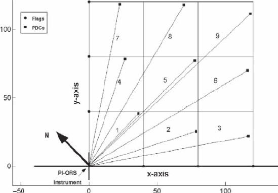
24 R.A. Hashmonay et al.
and (2) the PI-ORS instrument-specific detection limits of the expected target gases.
A recommended range for dwelling time per PDC is 10–60 s.
Once the PIC for all beam paths are averaged with the predetermined grouping of
cycles for the gas species of interest, the HRPM calculations make use of the informa-
tion to reconstruct a plume map over the area of interest. Average concentrations for
each pixel can be obtained by applying an iterative algebraic deconvolution algorithm.
The measured PIC, as a function of the field of concentration, is given by
PIC K c
kkmm
m
=
∑
(1)
where
K = a kernel matrix that incorporates the specific beam geometry with the pixel
dimensions;
k = the number index for the beam paths;
m = the number index for the pixels; and
c = the average concentration in the mth pixel.
Each value in the kernel matrix K is the length of the kth beam within the mth
pixel; therefore, the matrix is specific to the beam geometry. The HRPM procedure
solves for the average concentrations (one for each pixel) by applying non-negative
least squares (NNLS) algorithm (Lawson et al. 1995). The HRPM procedure
multiplies the resulting column vector of averaged concentration by the matrix K
to yield the end vector of predicted PIC data.
The second stage of the plume reconstruction involves interpolation among the
reconstructed pixel’s average concentration, providing a peak concentration not
limited to the center of the pixels. A triangle-based cubic interpolation procedure
Fig. 2.1 Example of an HRPM configuration setup
2 Radial Plume Mapping 25
(in Cartesian coordinates) is currently used in the HRPM procedure (Barber et al.
1996). The HRPM procedure provides a plume map and calculates the location
of the peak concentrations. It is up to the user to interpret this information, taking
into consideration site-specific characteristics such as obstructions or terrain
complexities, to determine the actual location of the hot spot.
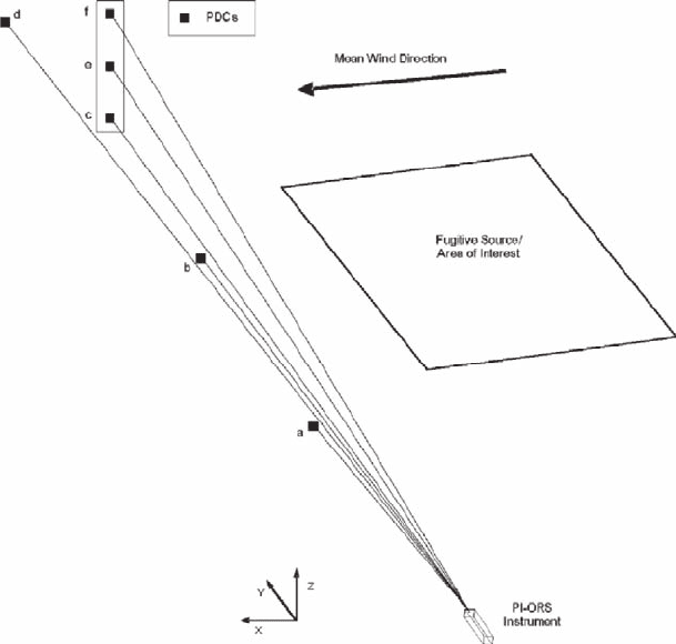
2.2.2 VRPM Methodology—Estimation of Emission Rate
The VRPM methodology is used to estimate the rate of gaseous emissions from an
area fugitive source. A vertical scanning plane, downwind of the source, is used to
directly measure the gaseous flux. Two different beam configurations of the
VRPM methodology are recommended: the five-beam (or more) and the three-
beam VRPM configuration. Figure 2.2 illustrates the setup for these two
VRPM beam configurations. In the five-beam (or more) configuration, the ORS
instrument sequentially scans over five PDCs. Three PDCs are along the ground-level
Fig. 2.2 Example of a VRPM configuration setup
26 R.A. Hashmonay et al.
crosswind direction (beams a, b, and c in Fig. 2.2), and the other two are elevated
on a vertical structure (beams e and f in Fig. 2.2). The additional beam (d) in Fig. 2.2
is for the six-beam configuration, which provides better spatial definition of the
plume in the crosswind direction. In the three-beam configuration, the ORS
instrument sequentially scans over three PDCs. Only one beam is along the ground
level (beam c or d in Fig. 2.2) and the other two are elevated on a vertical structure
(beams e and f in Fig. 2.2).
A two-phase smooth basis function minimization (SBFM) approach is applied
where there are three or more beams along the ground level (five-beam, or more,
configuration). In the two-phase SBFM approach, a one-dimensional SBFM
(1D-SBFM) reconstruction procedure is first applied in order to reconstruct the
smoothed ground level and crosswind concentration profile. The reconstructed
parameters are then substituted into the bivariate Gaussian function when applying
a two-dimensional SBFM (2D-SBFM) procedure.
A 1D-SBFM reconstruction is applied to the ground level segmented beam paths
(Fig. 2.2) of the same beam geometry to find the crosswind concentration profile.
A univariate Gaussian function is fitted to measured PIC ground-level values.
The error function for the minimization procedure is the sum of squared errors
(SSE) function and is defined in the 1D-SBFM approach as follows:
SSE B m PIC
B
mr
jyy i
j
y
j
r
y
y
jj
j
i
j
j
(, , ) exp
s
ps
s
=− −
−
⎛
⎝
⎜
⎜
⎞
⎠
⎟
⎟
⎡
∑
∫
2
1
2
0
2
⎣⎣
⎢
⎢
⎤
⎦
⎥
⎥
⎛
⎝
⎜
⎜
⎜
⎞
⎠
⎟
⎟
⎟
∑
dr
i
2
(2)
where
B = equal to the area under the one-dimensional Gaussian distribution (inte-
grated concentration);
r
i
= the pathlength of the ith beam;
m
y
= the mean (peak location);
σ
y
= the standard deviation of the jth Gaussian function; and
PIC
i
= the measured PIC value of the ith path
The SSE function is minimized using the simplex minimization procedure to solve
for the unknown parameters (Press et al. 1992). When there are more than three beams
at the ground level, two Gaussian functions are fitted to retrieve skewed and sometimes
bi-modal concentration profiles. This is the reason for the index j in Eq. 2.
Once the one-dimensional phase is completed, the two-dimensional phase of the
two-phase process is applied. To derive the bivariate Gaussian function used in the
second phase, it is convenient to express the generic bivariate function G in polar
coordinates r and q:
Gr
A
rm
yz
y
y
(, ) exp
(cos )
q
ps s r
r
q
s
=
−
−
−
()
⋅−
⎡
⎣
⎢
⎢
⎧
⎨
⎪
⎩
⎪
21
1
21
12
2
12
2
2
2
−−
⋅− ⋅−
+
⋅−
⎤
⎦
⎥
⎥
⎫
⎬
⎪
⎭
⎪
2
12
2
2
rq q
ss
q
s
(cos )(sin )
(sin )
rmrm
rm
yz
yz
z
z
(3)

2 Radial Plume Mapping 27
The bivariate Gaussian has six unknown independent parameters:
A = normalizing coefficient which adjusts for the peak value of the bivariate
surface;
r
12
= correlation coefficient which defines the direction of the distribution-
independent variations in relation to the Cartesian directions y and z (r
12
= 0 means
that the distribution variations overlap the Cartesian coordinates);
m
y
and m
z
= peak locations in Cartesian coordinates; and
s
y
and s
z
= standard deviations in Cartesian coordinates.
Six independent beam paths are sufficient to determine one bivariate Gaussian that
has six independent unknown parameters. Some reasonable assumptions are made
when applying the VRPM methodology to this problem to reduce the number of
unknown parameters. The first is setting the correlation parameter r
12
equal to zero.
This assumes that the reconstructed bivariate Gaussian is limited only to changes in
the vertical and crosswind directions. Secondly, when ground level emissions are
known to exist, the ground level PIC is expected to be the largest of the vertical
beams. Therefore, the peak location in the vertical direction can be fixed to the ground
level. In the above ground-level scenario, Eq. 3 reduces into Eq. 4:
Gr
A
rm
r
yz
y
yz
(, ) exp
(cos )
(sin)
q
ps s
q
s
q
s
=−
⋅−
+
⋅
⎡
⎣
⎢
⎢
⎤
⎦
⎥
⎥
⎧
⎨
2
1
2
2
2
2
2
⎪⎪
⎩
⎪
⎫
⎬
⎪
⎭
⎪
(4)
The standard deviation and peak location retrieved in the 1D-SBFM procedure are
substituted in Eq. 4 to yield
GA
A
rm
r
z
yD z
yD
yD z
,exp
(cos )
(sin)
s
ps s
q
s
q
s
()
=−
⋅−
+
⋅
−
−
−
2
1
2
1
1
2
1
2
2
2
⎡⎡
⎣
⎢
⎢
⎤
⎦
⎥
⎥
⎧
⎨
⎪
⎩
⎪
⎫
⎬
⎪
⎭
⎪
(5)
where
s
y-1D
= standard deviation along the crosswind direction (found in the 1D-SBFM
procedure);
m
y-1D
= peak location along the crosswind direction (found in the 1D-SBFM
procedure);
A and s
z
are the unknown parameters to be retrieved in the second phase of the
fitting procedure. An error function (SSE) for minimization is defined for this phase
in a similar manner. The SSE function for the second phase is defined as
SSE A PIC G r A dr
ziiiz
r
i
i
(, ) ,,,
sqs
=−
()
⎛
⎝
⎜
⎜
⎞
⎠
⎟
⎟
∫
∑
0
2
(6)
The SSE function is minimized using the simplex method to solve for the two
unknown parameters.
When the VRPM configuration consists only of three-beam paths—one at the
ground level and the other two elevated—the one-dimensional phase can be skipped,
assuming that the plume is very wide. In this scenario, peak location can be arbitrarily
28 R.A. Hashmonay et al.
assigned to be in the middle of the configuration. Therefore, the three-beam VRPM
configuration is most suitable for area sources or for sources with a series of point and
fugitive sources that are known to be distributed across the upwind area. In this case,
the bivariate Gaussian has the same two unknown parameters as in the second phase
(Eq. 5), but information about the plume width or location is not known. The standard
deviation in the crosswind direction is typically assumed to be about ten times that of
the ground level beam path (length of vertical plane). If r
1
represents the length of the
vertical plane, the bivariate Gaussian would be as follows:
GA
A
r
rr
r
r
z
z
z
(, )
()
exp
(cos )
()
(sin)
s
ps
q
q
s
=−
⋅−
+
⋅
210
1
2
10
1
1
2
1
2
1
2
2
22
⎡
⎣
⎢
⎤
⎦
⎥
⎧
⎨
⎪
⎩
⎪
⎫
⎬
⎪
⎭
⎪
(7)
This process is for determining the vertical gradient in concentration. It allows an
accurate integration of concentrations across the vertical plane as the long-beam
ground-level PIC provides a direct integration of concentration at the lowest level.
Once the parameters of the function are found for a specific run, the VRPM
procedure calculates the concentration values for every square elementary unit in a
vertical plane. Then, the VRPM procedure integrates the values, incorporating wind
speed data at each height level to compute the flux. The concentration values are
converted from parts per million by volume (ppmv) to grams per cubic meter
(g/m
3
), taking into consideration the molecular weight of the target gas. This enables
the direct calculation of the flux in grams per second (g/s), using wind speed data
in meters per second (m/s).
As described in earlier studies (Hashmonay et al. 2001), the concordance cor-
relation factor (CCF) was used to represent the level of fit for the reconstruction in
the path-integrated domain (predicted versus measured PIC). CCF is defined as the
product of two components:
CCF = rA
(8)
where
r = the Pearson correlation coefficient and
A = a correction factor for the shift in population and location.
This shift is a function of the relationship between the averages and standard
deviations of the measured and predicted PIC vectors:
A
PIC PIC
PIC
PIC
PIC
PIC
PM
PIC PIC
P
M
M
P
PM
=++
−
⎛
⎝
⎜
⎜
⎞
⎠
⎟
⎟
⎛
⎝
⎜
⎜
1
2
2
s
s
s
s
ss
⎜⎜
⎞
⎠
⎟
⎟
⎟
⎡
⎣
⎢
⎢
⎢
⎤
⎦
⎥
⎥
⎥
−1
(9)
where
s
PIC
P
= standard deviation of the predicted PIC vector;
s
PIC
M
= standard deviation of the measured PIC vector;
PIC
P
= the mean of the predicted PIC vector; and
PIC
P
= the mean of the measured PIC vector.
2 Radial Plume Mapping 29
The Pearson correlation coefficient is a good indicator of the quality of fit to
the Gaussian mathematical function. In this procedure, typically an r close to 1
will be followed by an A very close to 1. This means that the averages and stand-
ard deviations in the two concentration vectors are very similar and the mass is
conserved (good flux value). However, when a poor CCF is reported (CCF < 0.80)
at the end of the fitting procedure it does not directly mean that the mass is not
conserved. It could be a case where only a poor fit to the Gaussian function
occurred if the correction factor A was still very close to 1 (A > 0.90). However,
when both r and A are low one can assume that the flux calculation is
inaccurate.
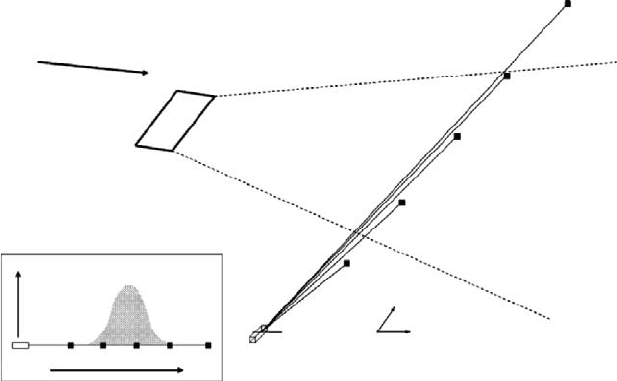
2.2.3 1D-RPM Methodology—Line-of-Sight Profile
Concentrations and Upwind Source Location Estimation
The 1D-RPM methodology is used to profile pollutant concentrations along a
line-of-sight downwind of a fugitive emission source. This pollutant concentration
profile can be combined with wind data to estimate the location of an upwind
source, when applicable (Hashmonay and Yost 1999b). The scanning PI-ORS
instrument and three or more PDC are placed in a crosswind direction along a line,
such as an industrial site fenceline, and PIC measurements are made. The 1D-RPM
configuration setup is shown in Fig. 2.3. A minimum of three PDCs are needed, but
four to six are recommended for this configuration. The additional PDCs provide a
more detailed concentration profile. PDCs should be placed on the line-of-sight,
with an equal distance between each subsequent PDC, if possible (see Fig. 2.3).
PI-ORS
Instrument
Conc.
Concentration Profile
wind direction
SOURCE
500 m
400 m
300 m
200 m
100 m
Y
x
PI-ORS Instrument
100 m
200 m
300 m
400 m 500 m
Y
Fig. 2.3 Example of a 1D-RPM configuration setup
30 R.A. Hashmonay et al.
Once the PIC for all beam paths are averaged with the predetermined grouping
of cycles for the gas species of interest, the 1D-RPM calculations make use of the
information to reconstruct a plume concentration profile along the measurement
line-of-sight. Similar to the case of VRPM, the 1D-RPM calculations utilize the
1D-SBFM to reconstruct a mass-equivalent plume concentration profile along the
line-of-sight measurement.
The 1D-RPM procedure fits a univariate Gaussian function to measured PIC
ground-level values. The error function for the minimization procedure is the SSE
function, and is defined in Eq. 2. The 1D-RPM procedure reconstructs the plume
profile along the measurement line-of-site and notes the peak location. Over time,
as the wind direction fluctuates, different peak locations are reconstructed from the
PIC measurements as illustrated in Fig. 2.4. Each time a peak location is noted,
a source projection line is drawn for each peak location. This is done by calculating
a line equation through the peak location, with the same orientation as the averaged
wind direction for the same measurement time interval. Ideally, for a stationary
point source, all source projection lines drawn over time should intersect at a point
upwind of the measurement line in the vicinity of the real emission source location.
Calculating the density of lines per unit area upwind from the measurement plane,
the most likely location of the source can be estimated as the region of the maximal
line density.
Fig. 2.4 An Example of a 1D-RPM fenceline monitoring setup