Karimi H.A. Universal Navigation on Smartphones
Подождите немного. Документ загружается.

40
which may not necessarily be optimal. Factors affecting choice of exact or heuris-
tic algorithms for navigation systems/services include acceptable response time,
networks size, and computational power. Acceptable response time is an important
factor in navigation systems/services for computing routes, especially rerouting that
is typically computed in real time while the vehicle is moving. Network size is de-
termined by the total number of nodes (e.g., intersections) in a network. In general,
the larger the number of nodes, the longer the computation will be. Computational
power of a navigation device is another factor that impacts performance of rout-
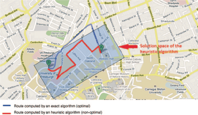
ing and rerouting. Figure 2.12 illustrates an example of an optimal route (in blue)
computed by an exact algorithm and an example of a good (non-optimal) route (in
red) computed by a heuristic algorithm. In this example, the strategy by the heuris-
tic algorithm is to trim the entire network (solution space) to a smaller network (a
window around the origin and destination locations as shown in Figure 2.12). By
using the sub-network (the network within the window), the heuristic algorithm
only considers some of the routes surrounding the origin A and the destination B
locations to find a solution, which may be acceptable but not optimal.
Other than incorrect geocoded destination addresses, which are of geometrical
errors, topological errors and attribute errors in networks result in incorrect routes
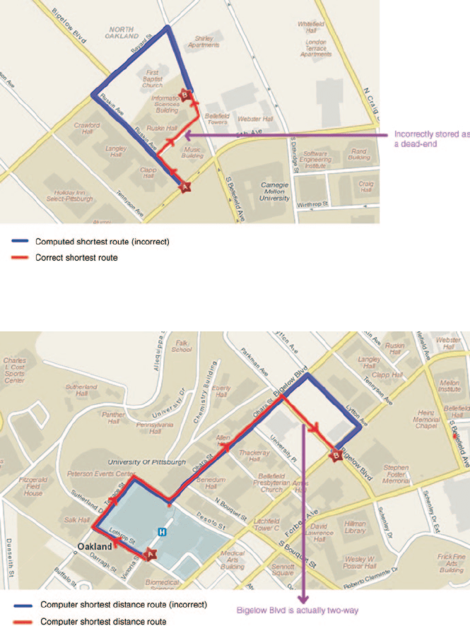
as well. Figure 2.13 shows an example where the computed shortest route (in blue)
is different and longer, due to topological errors (e.g., a road segment is incorrectly
stored as dead-end), than the actual shortest route (in red). Figure 2.14 shows an ex-
ample where attribute errors (e.g., incorrect road segment orientation, one- or two-
way) result in a route which is different and longer than the actual shortest route.
Fig. 2.12 An optimal route computed by an exact algorithm and a non-optimal route computed
by a heuristic algorithm
2 Outdoor Navigation
41
Tracking. The tracking function is responsible for the continuous monitoring of
user’s location in real time. The input to the tracking function is the position data ac-
quired continuously from geo-positioning sensor(s) at a fixed interval (time or dis-
tance) where it is used for map matching. The output is the real-time location of the
Fig. 2.13 An example of an incorrect route due to topological errors
2.3 Functions
Fig. 2.14 An example of an incorrect route due to attribute errors
42
user displayed on the map traveling, on a road segment or sidewalk segment. The
data needed in the tracking function include road/sidewalk networks, road/sidewalk
segments, and attribute data. The key to the tracking function is the map matching
algorithm which performs two tasks: (a) finding the segment (road/sidewalk) on
which the user is and (b) finding the precise location of the user on the segment.
There are many map matching algorithms, but they all are based on one of the three
fundamental approaches: point-to-point, point-to-curve, and curve-to-curve. There
are advantages and disadvantages with each of these approaches and map matching
algorithms based on these approaches tend to exploit their advantages while over-
coming their disadvantages.
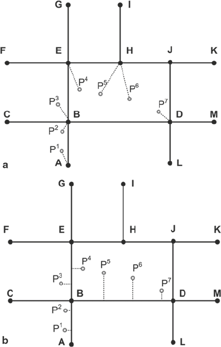
For illustrative purposes, in Figure 2.15 results of two map matching approaches,
point-to-point and point-to-curve, are highlighted. It is assumed in this figure that
a vehicle is travelling on segments AB and BD and the position data obtained from
Fig. 2.15 Examples of
map-matched results using
different algorithms. a Point-
to-point map matching.
b Point-to-curve map
matching
2 Outdoor Navigation
43
geo-positioning sensors are indicated by P
1
to P
7
. The map-matched results of the
point-to-point approach in Figure 2.15 (a) show that the vehicle travels from AB to
BE to EH and to BD. The map-matched results of the point-to-curve approach in
Figure 2.15 (b) show that the vehicle travels from AB to BE and to BD. Both algo-
rithms produce incorrect results for P
3
and P
4
.
Direction. The direction function uses the computed route to provide instruc-
tions on how to travel from the origin to each segment of the route to reach the desti-
nation. The input to the direction function is a route and the output is a set of instruc-
tions to navigate on the route displayed on the map and/or presented through voice.
The set of instructions basically utilizes information on intersections, distances on
road segments, and landmarks. The input to the direction function includes road/
sidewalk networks, road/sidewalk segments, and attribute data.
Direction generation refers to the process of generating step-by-step instructions
for a given route, which involves two main steps. First, instructions are generated
for the entire route from origin to destination. This information is usually delivered
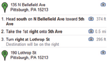
to the user as text. Figure 2.16 shows an example of such directions. Second, the
instructions generated in the first step are presented to the user turn-by-turn in real
time, using the tracking function, based on vehicle’s position.
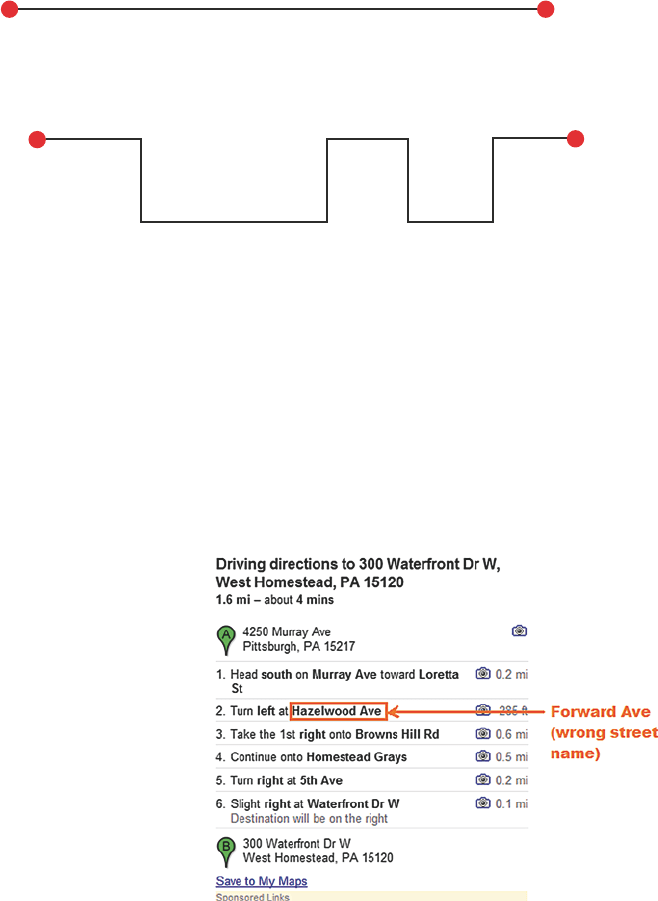
In general, navigation, and consequently directions, could be simple or complex.
Factors impacting directions to be simple or complex include navigation environ-
ment (structure and density), route length, route complexity in terms of decision
points, and user’s familiarity with the navigation environment. Figures 2.17 (a) and
(b) show examples of routes and directions on them. In Figure 2.17 (a) direction is
simple as only one road segment exists in the computed route, whereas in Figure
2.17 (b) direction is complex as there are many decision points where the user must
make decision.
Each step of direction generation introduces some uncertainties, mainly associ-
ated with road attributes, to the resultant directions. The main sources of errors in
the first step of direction generation are segment name and segment length. The
sources of errors in the second step of direction generation are associated with ve-
hicle’s position determination at each time epoch using map matching and distance
2.3 Functions
Fig. 2.16
Example direction
generated between a pair of
addresses
44
estimation to the next decision point based on vehicle’s position, speed, and current
road segment length. Figure 2.18 shows an example of generated directions with an
incorrect street name.
Fig. 2.18 An example of
direction errors due to incor-
rect street name
2 Outdoor Navigation
Fig. 2.17 Example directions. a Simple directions. b Complex directions
Road A
a
b
Road A
Road C Road G
Origin
2km
1km
2km
Road E
Road B Road D Road F Road H
2km2km
2km4km
2km2km
Road I
10km
Destination
Destination
1. Go straight forward on road A for 10km
1. Go straight forward on road A for 2 km
3. Go straight forward on road B for 2 km
2. Turn right on road B
4. Turn left on road C
5. Go straight forward on road C for 4 km
6. Turn left on road D
7. Go straight forward on road D for 2 km
9. Go straight forward on road E for 1 km
8. Turn right on road E
11. Go straight forward on road F for 2 km
10. Turn right on road F
13. Go straight forward on road G for 2 km
12. Turn left on road G
17. go straight forward on road I for 2 km
16. Turn right on road I
15. Go straight forward on road H for 2 km
14. Turn left on road H
45
2.4 Static and Dynamic Navigation
Outdoor navigation systems/services can operate either in static mode or in dy-
namic mode. In static mode (or stand-alone mode), the navigation system/service
uses only the data stored in its database and it has no access to real-time information
such as traffic, weather, or accidents. Rerouting in static mode occurs only when the
user deviates from the computed route, in which case the new location of the user is
used to compute a new route to the destination.
In dynamic mode, in addition to the stored database the navigation system/ser-
vice has access, through a wireless communication system, to remote resources.
Such remote resources could be real-time weather information, real-time traffic up-
dates, real-time road accidents, among others, within the traveling range. Rerouting
in dynamic mode may occur when the user deviates from the computed route or
when new real-time information affecting the travelling route is made available to
the system/service. In this case, the navigation system/service uses the current loca-
tion of the user to compute a new route (which may contain a portion of the original
route computed at the start of the trip) by taking into account the newly acquired
real-time information. For example, if user’s preference for routes is least congest-
ed, then the navigation system/service capable of dynamic mode will continually
check for traffic information on the upcoming segments of the original computed
route. If the information it receives indicates congestion on the segments that the
user is about to reach, it re-computes a new route to the destination, replaces it with
the original computed route and presents it to the user.
2.5 User
The technologies and techniques that are appropriate for outdoor navigation were
discussed in the previous sections. In this section, we focus on usability, another
important aspect of navigation systems/services. Usability in outdoor navigation
systems/services is defined as the accessibility of navigation functions and features
by its users. Given that outdoor navigation systems/services can benefit from a wide
range of hardware and technologies and that the demand for navigation systems/
services is continually increasing, navigation vendors are paying more attention
to the usability aspect of their products. For an outdoor navigation system/service
to be able to provide appropriate guidance, it is required that it supports various
features such as map representation, navigation situations, purpose of trip, and user
preferences. Table 2.9 shows the usability features for different modes of travel in
outdoor navigation systems/services.
In Table 2.9 users are categorized based on mode of travel, (i.e., car/motor driv-
er, pedestrian, bike rider, and wheelchair rider). For each group, map presentation,
navigation situation (static or dynamic), purpose of trip, and user preferences with
respect to POI, route, and map presentation are analyzed and described below.
2.5 User

46
Mode of
Travel
Map Presentation Navigation Situation Purpose of
Trip
User Preferences
Static Dynamic Route POI Map Presentation
Driver/ Motor
rider
Streets; Roads;
Landmarks
Safety; Toll Traffic; Weather;
Time;
Accident;
Route under
construction
Commute Shortest path; Fastest time;
Least intersections;
Avoid tolls; Least left
turns; Safe route; Low
congestion
Office; School;
Home; Library
Voice/text directions; Color;
Brightness; Screen size;
Font size; Map scale;
Selected POIs
Emergency Shortest path; Fastest time;
Low congestion
Hospital; Clinic;
Pharmacy
Leisure Scenic route; Avoid tolls;
Safe route; Low
congestion
Restaurant; Bar;
Shopping mall
Pedestrian Sidewalk; Build-
ings; Landmarks
Safety Weather; Time;
Route under
construction
Commute Shortest path; Safe route Office; School;
Home; Library
Voice/text directions; Color;
Brightness; Screen size;
Font size; Map scale;
Selected POIs; Unsafe
neighborhood
Leisure Safe route; Scenic route Shopping center;
Restaurant; Park;
Bookstore
Bike Rider Streets; Roads; Side-
walks; Build-
ings; Landmarks
Safety; Toll Weather; Traf-
fic, Time;
Accident;
Route under
constructions
Commute Shortest path; Least
intersections; Least
left turns; Route with
feasible slope; Safe
route
Office; School;
Home; Library
Voice/text directions; Color;
Brightness; Screen size;
Font size; Map scale;
Selected POIs; Unsafe
neighborhoods
Leisure Least intersections; Least
left turns; Route with
feasible slope; Safe
route; Scenic route
Shopping center;
Restaurant; Park;
Book store
Wheelchair
Rider
Sidewalk; Buildings;
Landmarks;
Inaccessible
routes
Safety;
Slopes;
Curbs;
Steps
Traffic;Weather;
Safety;
Obstacles
Commute Shortest path; Least left
turns; Route with fea-
sible slope; Safe route;
Avoid obstacles; Avoid
curbs; Avoid steps
Office; School;
Home; Library
Voice/text directions; Color;
Brightness; Screen size;
Font size; Map scale;
Selected POIs; Unsafe
neighborhoods; Inaccessible
routes
Table 2.9 Usability features in outdoor navigation systems/services
2 Outdoor Navigation
47
Map presentation: Maps play a major role in an outdoor navigation system/
service as they are the media with which users interact the system/service. A map
for navigation purposes must provide the right amount of information, as both in-
complete and excessive information may confuse the user; present the orientation
dynamically in the direction of travel; and display each set of different objects in
a different color. These parameters may be computed and presented differently for
each mode of travel. For example, for car/motor drivers, road networks along with
relevant objects (e.g., landmarks) on or around road segments that assist in naviga-
tion are appropriate. For pedestrians, sidewalk networks and relevant objects (e.g.,
buildings and landmarks) on or around sidewalk segments are appropriate. For bike
riders, since the user may ride on both roads and sidewalks, the presentation may
include both road networks and relevant objects on road segments and sidewalk
networks and relevant objects on sidewalk segments. In areas where bike riders
are required to bike only on designated paths, the presentation must include only
such paths and relevant objects on them. For wheelchair riders, sidewalks, build-
ings, landmarks, and accessible routes must be presented. Due to the impediments
in passing inaccessible routes, such as curbs, steps, obstacles, and slopes with more
than a specific amount, by wheelchair riders, the map either must not present them
at all or present them in such a way that are not confusing to wheelchair riders.
Building a navigation system/services that is capable of representing maps ap-
propriate for each mode of travel as discussed above is complex, which is why most
current navigation systems/services are designed for one mode of travel, though
new navigation systems/services that are multi-modal are emerging.
Navigation situation: One way to analyze navigation situations for each mode
of travel is categorizing them into one of two groups: static and dynamic. Static
navigation situations are situations which affect user preferences and do not change
over time. Dynamic navigation situations are those which are temporary (i.e.,
changing over time). For drivers and motor riders, safety and tolls are considered
as static situations, whereas weather, accidents, roads under construction, and road
side development are considered as dynamic situations. For pedestrians, safety is
considered as static navigation situation, and weather, time of day, sidewalks under
construction are considered as dynamic situations. For bike riders, since they can
ride on both roads and sidewalks, navigation situations are the combination of those
for drivers/motor riders and pedestrians. For wheelchair riders, safety, slopes, curbs,
and steps are considered as static navigation situations, and traffic, weather, safety,
and obstacles are considered as dynamic situations.
Purpose of trip: User’s preferences usually vary based on purpose of trip. One
may prefer to take a different route while commuting than a route between the same
origin and destination locations when purpose of trip is leisure. For instance, con-
sider a restaurant next to a user’s office. The user drives from his/her house to the
office everyday, a specific time, which may be during rush hours, impacting his/her
preferences with respect to fastest, shortest or least congested route. However, when
going to the restaurant next to his/her office during the weekend, his/her preference
might be a scenic route which could be even a longer route.
2.5 User
48
User’s preferences can be categorized (see Table 2.6) based on three different
purposes of trip for drivers/motor riders (i.e., commute, emergency, and leisure),
two purposes of trip for pedestrian and bike riders (i.e., commute and leisure), and
one purpose of trip for wheelchair riders (i.e., commute). For each purpose of trip,
user’s preferences for routes and POIs are identified. For drivers and motor riders
there are several preferences such as shortest, fastest, least turns, non-toll, least left
turns, safest, or least congested route when commute is purpose of trip. Typical
everyday POIs include office, school, home, and library. In emergency situations,
since time is of the essence, shortest, fastest, and least congestion routes are usu-
ally preferred. Typical emergency POIs include hospital, clinic, and pharmacy. In
addition, preferences for trips chosen as leisure are determined as scenic, non-toll,
safest, and least-congested routes. Typical leisure POIs include restaurant, bar, and
shopping mall.
Likewise, as Table 2.6 shows, preferences for pedestrians, bike riders, and
wheelchair riders are determined based on purpose of trip. However, these prefer-
ences are not confined to those aforementioned, and also may vary user by user. The
complexity of an outdoor navigation system/service is affected by different needs
and preferences they address.
User’s preferences presented on maps are usually independent of purpose of trip.
These preferences are roughly the same for each mode of travel with minor differ-
ences. Regardless of mode of travel and purpose of trip, each user has some prefer-
ences for receiving directions (via voice or text) and presenting color and bright-
ness, font size, map scale, and screen size of the device. However, for presenting
upcoming POIs and landmarks, users often prefer to be notified of the ones which
are related to their purpose of trip (e.g., parks in leisure and hospitals in emergency
situations). Moreover, for pedestrians, bike riders, and wheelchair riders presenting
unsafe neighborhoods and inaccessible routes for wheelchair riders would be useful.
2 Outdoor Navigation
Fig. 2.19
Computed route on a road network
49
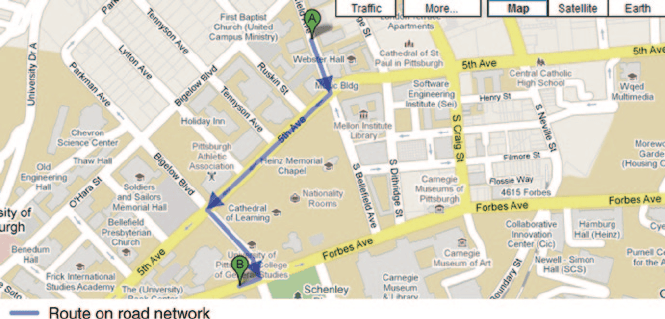
Figure 2.19 shows an example of a route for outdoor navigation. In this figure
the computed route between A and B locations are highlighted on a road network of
the navigation environment.
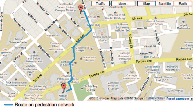
Figure 2.20 shows an example of a route for outdoor navigation. In this figure the
computed route between A and B locations are highlighted on a sidewalk network
of the navigation environment.
Table 2.10 shows a sample of navigation systems/services currently in the mar-
ket. Navigation vendors featured in this table are Garmin, TomTom, Magellan, and
Pioneer. In this table, the products by each navigation vendor along with their gen-
eral characteristics are highlighted.
2.6 Summary
In this chapter, characteristics, technologies, and techniques of outdoor navigation
systems/services are discussed. The main technologies in navigation systems/ser-
vices are geo-positioning, wireless communication, and database. Of the possible
geo-positioning sensors, GNSS, currently GPS, is the main geo-positioning sensor
for outdoor navigation. GPS and its uncertainty are described. Wireless communi-
cation systems and their use in outdoor navigation systems/services are discussed.
Road and sidewalk networks, composed of road/sidewalk segments, constitute the
core of data in outdoor navigation systems/services. The main functions performed
by today’s modern outdoor navigation systems/services are POI retrieval, map cre-
ation, geocoding, routing/rerouting, and tracking. Static and dynamic navigation,
users, and routing options in outdoor navigation systems/services are described.
2.6 Summary
Fig. 2.20
Computed route on a sidewalk network
