Japanese National Committee on Large Dams. Dams in Japan, No. 8
Подождите немного. Документ загружается.

TYPICAT CROSS SECTION
U-l
gnp-
!r50.o
90.o
t50.o
Rigtrt Abutncnt
PTAN
PROFITE
ALONG DAM AXIS
47
24.ASAHI
DAM
Location
. i
-
Nearest
city
.
.
River.
Purpose.
Catchment area.
.
Mean
annualdischarge.
Years
of construction
. . . .
Type
.
Foundation
......
Height.
Crest
length
Volume
Spillway
Type.
Type
and number of
gate
Maximum
discharge
capacity.
Reservoir
Cross capacity
Effective
capacity
Area.
.
Drawdown range
.
Owner.
Engineeringby....
Construction
by. .
Totsukawa-mura,
Yoshinogun,
Nara-ken
Cojyo
Asahi
Hydroelectric
39.2km2
2.51m3/s
1975
-
1978
Arch
Sandstone
86m
200m
147,300m3
Controlled
Crest
radial
gate
x
3
1,200m3/s
15,920,000m3
12,500,000m3
0.56km2
32m
Kansai
Electric
Power
Co.,
lnc.
Ditto
Hazama{umi,
Ltd.
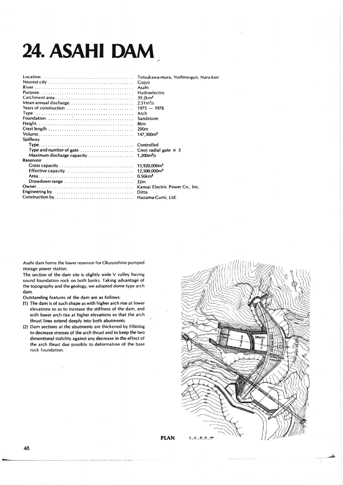
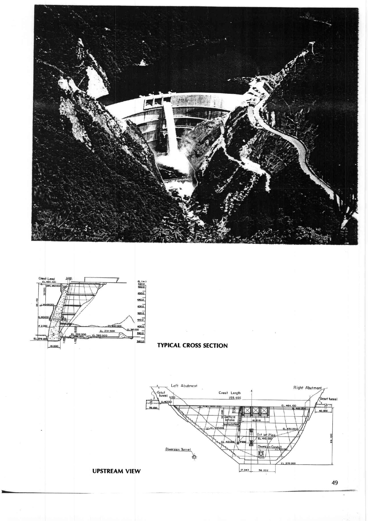
Asahi dam forms the
lower reservoir for Okuyoshino
pumped
storage
power
station.
The section of the dam site
is
slightly
wide
V
valley
having
sound
foundation rock
on both
banks.
Taking advantage
of
the
topography and the
geology,
we adopted
dome
type arch
dam.
Outstanding
features of the dam are
as follows:
fl)
The dam is of
such shape as
with
higher arch
rise
at
lower
elevations
so as
to increase the stiffness
of
the dam, and
with lower
arch
rise
at
higher elevations
so
that the arch
thrust lines extend deeply into both
abutments.
(2)
Dam
sections at
the
abutments
are
thickened
by f
illeting
to
deerease stresses of the arch
thrust
and
to keep
the two
dimentional stability
against
any
decrease
in the
effect
of
the
arch
thrust
due
possibly
to deformation
of the base
rock foundation.
48
PIAN
A-
lh
it64.o
.so
o
.l$.o
4aoo
.Rbo
.r20.o
iaroo
.16'0
D
5e.ol
l
llsL9l
TYPICAT
CROSS
SECTION
UPSTREAM
VIEW

zs.MITA
DAM
Location
Nearestcity....
...:..::
.:.....::............
:
River.
Purpose.
Catchment
area.
.
Mean
annual
discharge.
Years
of
construction
. . . .
Type
.
Foundation
Height.
Crest length
Volume
Spillway
Type.
Type
and number
of
gate
.
Maximum
discharge
capacity.
Reservoir
Cross capacity
Effective
capacity
Area.
Drawdown
range
.
Owner.
Engineeringby....
Construction
by.
.
/
Nishinoshirna-cho,
Ok
i-gun,
Shimane.ken
Matsue
Mita
Flood
control, Water supply
and lrrigation
2.15km
1976
-
1978
Cravity
Tuff
and Tuff breccia
27m
105m
17,800m3
Uncontrolled
Emergency
gate
-
Jet
flow
gate
x
1
38m3/s
391,000m3
368,000m3
0.04km2
19.9m
Shimane'ken
Ditto
Konoike
Construction
Co., Ltd.
TYPICAT CROSS
SECTION
(ovERsPrrr)
50
'*
Mita
Dam
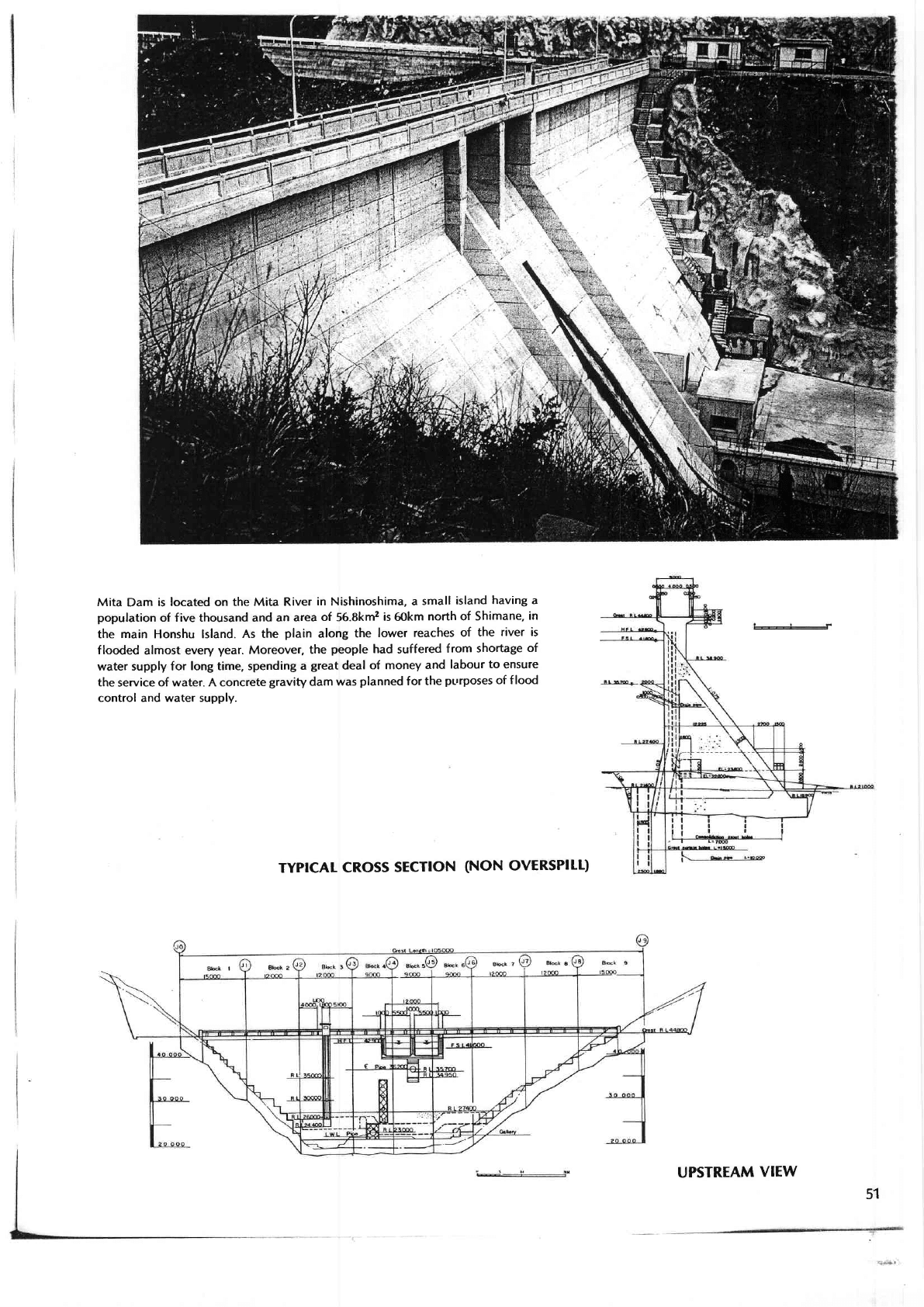
is located on
the Mita River
in
Nishinoshima,
a
small
island
having a
population
of f ive thousand and an
area
of
56.8km2
is
6okm
north of Shimane,
in
the main Honshu lsland.
As the
plain
along
the
lower
reaches
of
the
river is
flooded
almost every
year.
Moreover,
the
people
had
suffered
from
shortage
of
water supply for
long time, spending
a
great
deal
of money
and
labour
to
ensure
the
service
of water. A concrete
gravity
dam
was
planned
for
the
pL'rposes of f lood
control and water supply.
TYPICAI
CROSS
SECTION
(NON
OVERSPILL)
UPSTREAM
VIEW
51
26.MYOftN
DA/yl
Location
Nearestcity..
...
...............
.....
River.
Purpose.
Catchment
area.
.
Mean
annualdischarge
Yearsof
construction
.
. ... .
. .
Type
.
Foundation
Height.
Crest length
Volume
5pillway
Type.
.
Type
and number
of
gate
Maximum
discharge
capacity.
Reservoir
Crosscapacity...
Effective
capacity
Area.
.
Drawdown
range
.
Owner.
Engineeringby....
Construction
by.
.
H iroshima-shi,
H iroshima-ken
H iroshima
Nabara
Hydroelectric
1.4kmz
0.026m3/s
1972
-
1976
Rockf ill
Biotitegranite
89m
4O2m
3,268,000m3
Uncontrolled
80m3/s
6,145,000m3
5.220,000m3
O.247kmz
28.5m
Chugoku Electric Power
Co., lnc.
Ditto
Taisei
Corporation
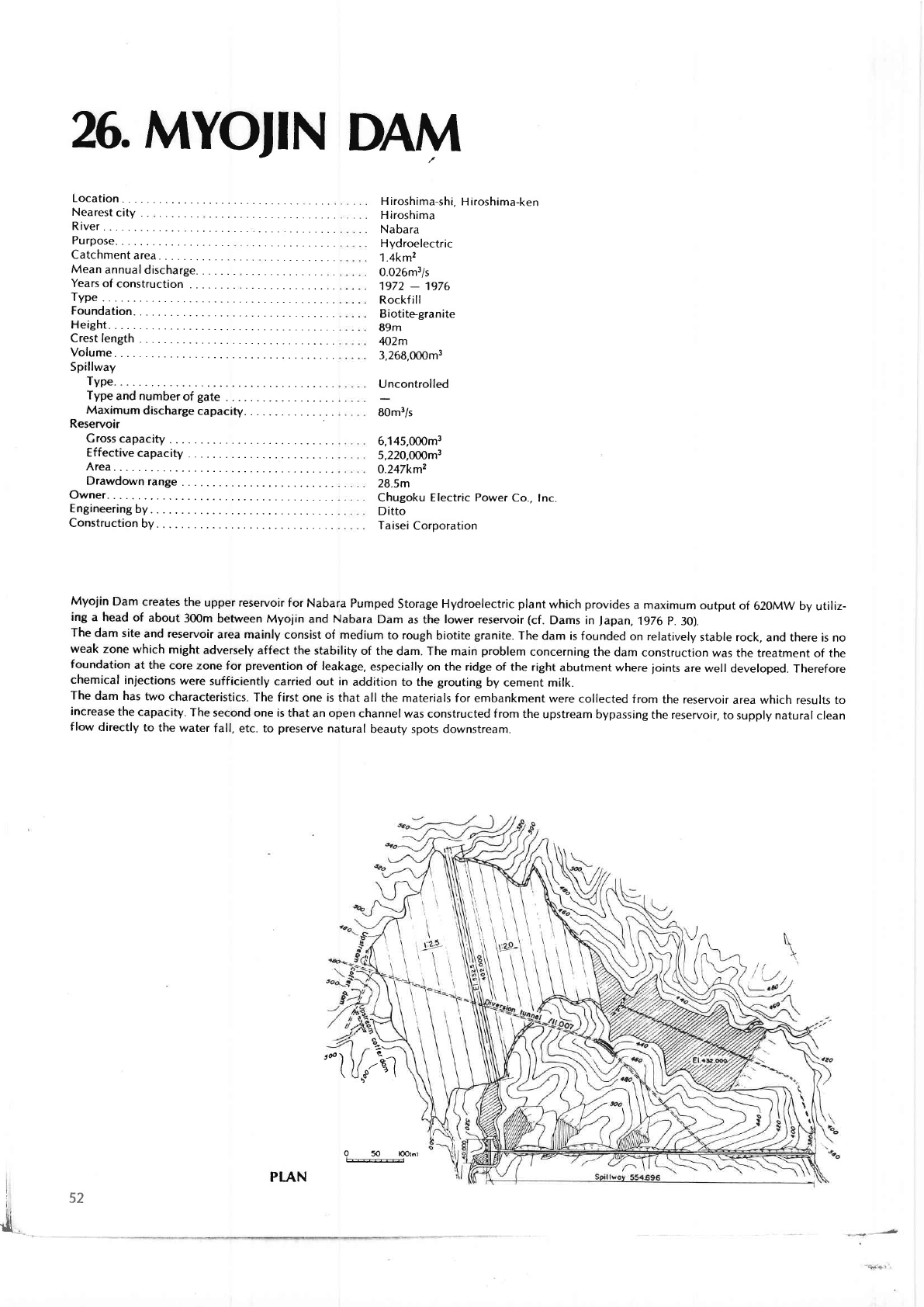
Myojin
Dam creates
the upper reservoir
tor Nabara
Pumped
Storage Hydroelectric
plant
which
provides
a maximum output
of 62oMw by
utiliz-
ing a head
of abotit
300m
between Myojin
and
Nabara
Dam
as the
lower reservoir
(cf.
Dams in
Japan,
1976
p.
3O).
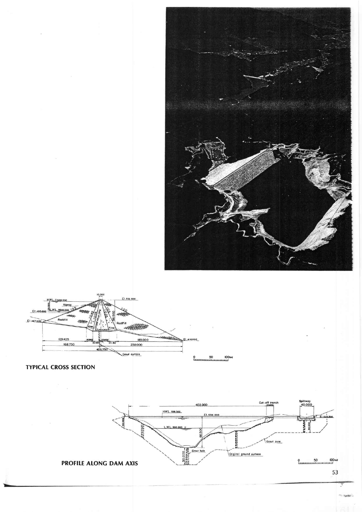
Ttte
dam site
and reservoir
arca mainly
consist of medium
to rough biotite
granite.
The
dam is founded
on relatively
stable rock,
and there is no
weak zone
which might
adversely
atfect the stability
of the dam. The main
problem
concerning the
dam
construction was the
treatment of the
foundation
at the core
zone for
prevention
of leakage, especially
on the ridge of the right
abutment where
joints
are well
developed. Therefore
chemical
injections
were
sufficiently caried out in
addition to the
grouting
by cement milk.
The dam has
two
chaaacteristics.
The first one is that
all the materials for embankment
were collected
lrom the reservoir
area which resultJ to
incrcase
the
capacity.
The second one is
that an open channelwas
constructed from the
upstream bypassing
the reservoir,
to supply natural cjean
flol,v
directly to
the water
fall, etc. to
preserue
natural
beauty spots downstream.
trl
I
50
lOotmt
g\!_
2v
q
.%)
2l
,rS
isz
trii
8l
Et-
PtAN
TYPICAT
CROSS SECTION
PROFITE
ALONG DAM AXIS
T.ODO
DAM
Location
Nearest
city
. .
River.
Purpose.
Catchment
area.
.
Mean
annual discharge.
Years of
construction .
. . .
Type .
Foundation
Height.
Crest
length
Volume
Spillway
Type.
.
Type
and
number
of
gate
Maximum
d
ischarge
capacity.
Reservoir
Cross capacity
Effective capacity
Area.
Drawdor,vn
rang,e
.
Owner.
Engineeringby....
Construction
by.
.
Niyodomura,
Takaoka-gun, Kochi-ken
Kochi
Niyodo
Flood control,
Hydroelectric,
lrrigation and Water supply
688.9km2
20.1m3/s
1966
-
(1982)
under
construction
Gravity
Schalstein
and Chert
96m
325m
1,000,000m3
Controlled
Crest
radial
gate
x
4 and
Orifice
radial
gate
x
5
7,700m3ls
66,000,000m3
52.000,000m3
2.01km2
4Om
Ministry
of
Construction
Ditto
Taisei Corporation
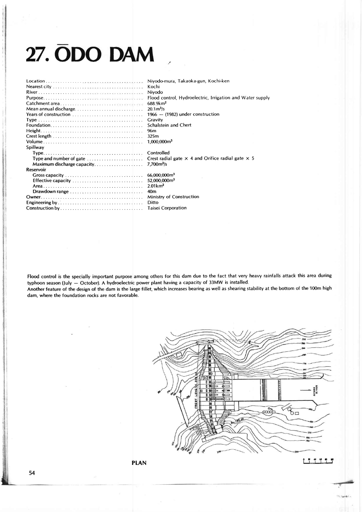
Flood contlol is the specially important
purpose
amon8 others
for this dam
due to the fact that
very heaw rainfalls attack
this area du.ing
typhoon season
(ruly
-
October).
A
hydroelectric
porver
plant
having a capacity
of
33MW
is installed.
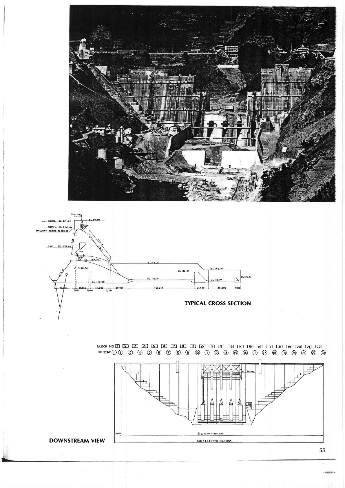
Another
feature of the
design of
the dam is the
la.ge fillet which increases
bearing a5 well as
sh€aring stability at the bottom
of the 1mm
high
dam.
where the foundation rocks are not favorable.
o
t
4! 6t
g
l-r-l-L-l-l
54
PLAN
t.ll+'
-
DOWNSTREAM
VIEW
TYPICAT
CROSS
SECTION
BLOCK.NoB
TN
E E] FJ tE] EI
IE-]
E
fpf E]
@ E1
E] E E]
E El E E
@ @
uornrr'roe@
O @ O @ O @ O
@ O @
@
@
@ @ @ @
@
@ @
@
@
?B.TERAUCHI
DAM
Location
Nearest
city . .
River.
Purpose.
Catchment area.
.
Mean
annualdischarge.
Years of
construction
. . . .
Type
.
Foundation
Height.
Crest
length
Volume
Spillway
Type.
.
Type and numberof
gate
. .
Maximum
d
ischarge
capacity.
Reservoir
Gross
capacity
Effective capacity
Area.
.
Drawdown
range
.
Owner.
Engineeringby....
Construction
by.
.
/
Amagi-shi, Fukuoka-ken
Amagi
Sata
Flood control,
lrrigation
and Water supply
51kmz
2.12m3ls
1971
-
1977
Rockf
ill
Black
schist
83m
42Om
3,000,000m3
Controlled
Orifice
radial
gate
x
1
and
Crest
fixed
roller
gate
x
2
1,O8Om3/s
18,000,000m3
16,000,000m3
0.9km2
38.5m
Water Resources
Development
Public
Corp.
Ditto
J.V.
of Hazama4umi,
Ltd. and
Japan
Development
& Construction
Co.,
Ltd
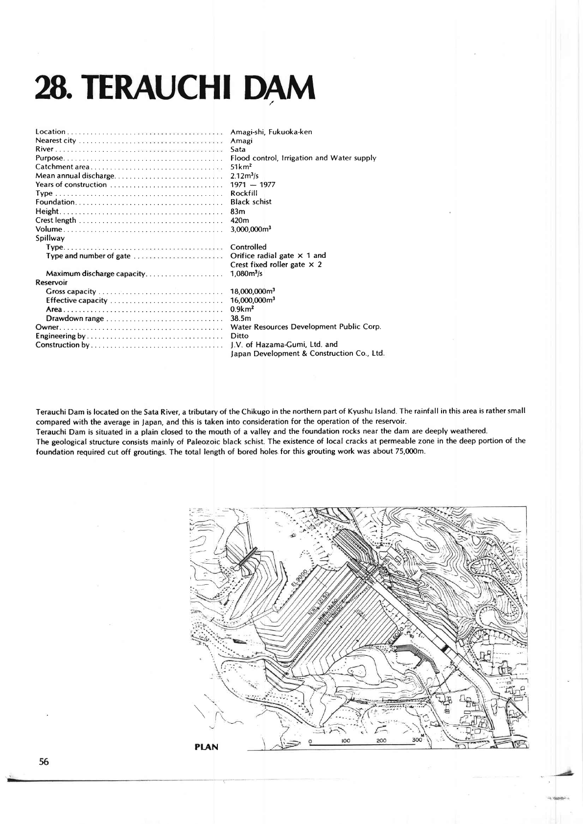
Terauchi Dam is lbcated on th€
Sata
River, a tributary
of the
Chikugo
in the
northern
part
of Kyushu lsland. The
rainfall in this area is
rather
small
compared with the average in
Japan,
and this
is taken into consideration
for the operation of the
rcse.voi..
Terauchi Dam is situated in a
plain
closed to
the mouth of a valley and
the foundation
rocks near the dam are deeply weathered.
The
geological
strucfure
consists
mainly of Paleozoic black
schist The existence
of local cracks at
p€.meable
zone in the deep
portion
of the
loundation requited cut off
grootings.
The total
len8th of bored
holes for this
grouting
work
was about 75,00om.
f
i,r\
Irt
56
PIAN
