Japanese National Committee on Large Dams. Dams in Japan, No. 10
Подождите немного. Документ загружается.

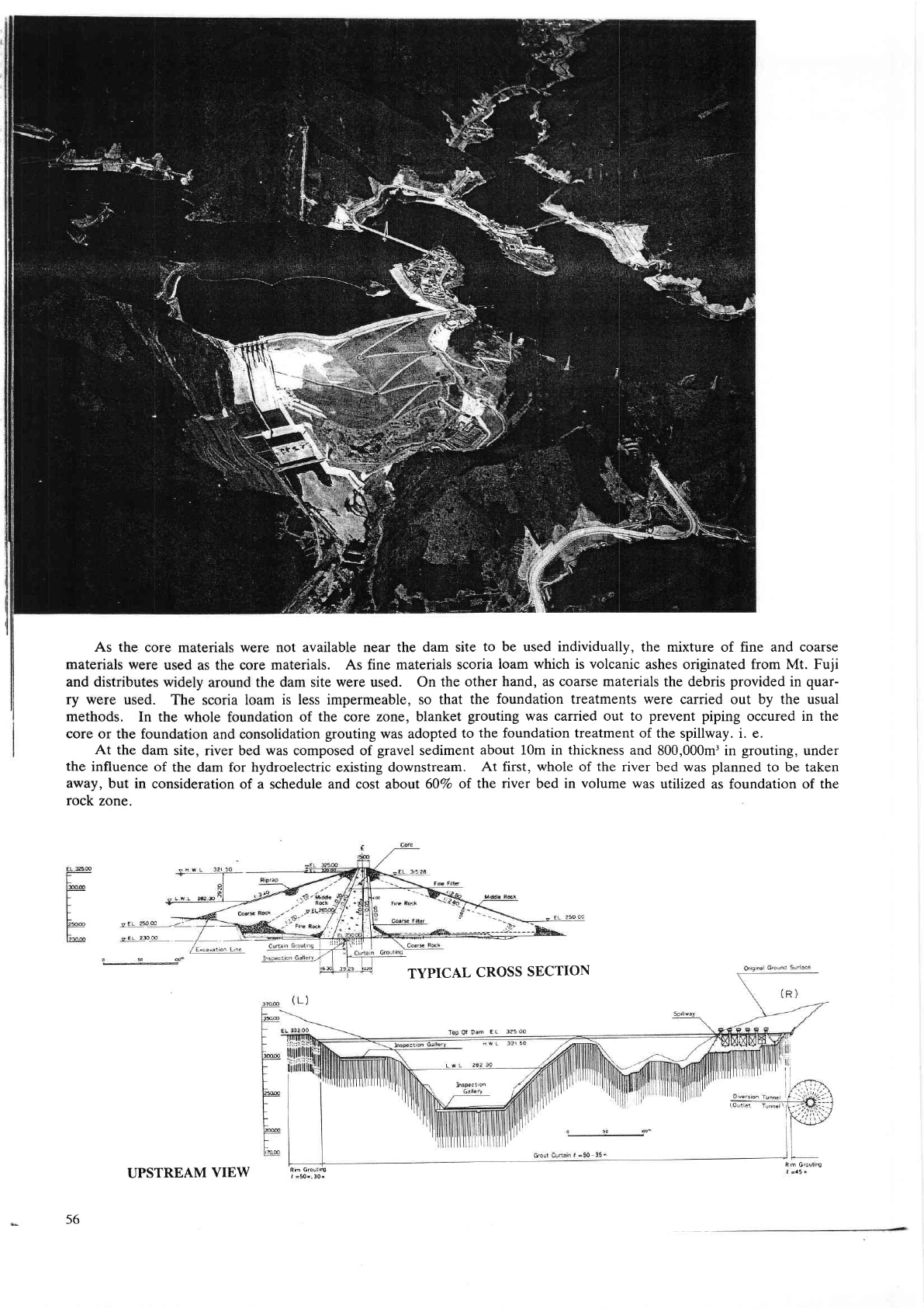
As
the core materials were not available near th€
dam site to be used individually, the mixture of fine and coarse
materials
were
used as the core
materials. As fine materials scoria
loam which is volcanic ashes originated ftom Mt. Fuji
and disfibutes v,ridely
around the
dam site were used. On the
other hand, as coa$e materials the debris
provided
in
quar-
ry were
used. The scoria loam is less impermeable,
so that the
foundation
treatments were carried out by the usual
methods. In the whole
foundation
of the core mne, blanket
grouting
was carried out to
prevent piping
oc.cured in the
core or
the foundation and consolidation
grouting
was adopted to
the foundation treatment of the spillway. i. e.
At the dam
site, river bed was composed of
gravel
sediment
about 10m in thickness
and 800,000m3 in
grouting,
under
the
influence of
the dam for hydrcelect c eisting downstream.
At fiIst, whole of the dver bed was
planned
to be taken
away, but in
consideration of a schedule and cost about @Ea ol
the river bed in volume was
utilized as foundation of the
rock zone.
Rm G
S
a5
TYPICAL
CROSS
SECTION
Rm
G
I
50 30
56
UPSTREAM
VIEW
18.
MIYAMA
DAM
(AND
NUMAPPARA
DAM)
Location
Nearest
City
.
River
Purpose
Catchment
area
Mean
annual
discharge
Years
of construction
.
Type
Foundation
Height
Crest
length
Volume
Spillway
Type
Type
and
number
of
gate
.
Maximum
discharge
capacity
Reservoir
Gross
capacity
Effective
capacity
Area
Drawdown
range
Owner
Engineering
by
Construction
by
Kuroiso-shi, Tochigi-ken
Kuroiso-shi
Nakagawa
Irrigation, Hydroelectric
and Water
supply
53Km'?
3.7m3ls
1969-1974
Rockfill
Rhyolite and
Quartz
andesite
breccia
tuff
76m
334m
1,967,000m3
Controlled
Crest radial
gate
X
3
840m3/s
25.8X lClum'
20.9x Lffm'
0.97Km'?
32m
M. A. F.
F., Tochigi-ken and E. P.
D.
C.
Ministry of
Agriculture, Forestry
and Fisheries
Taisei Corporation
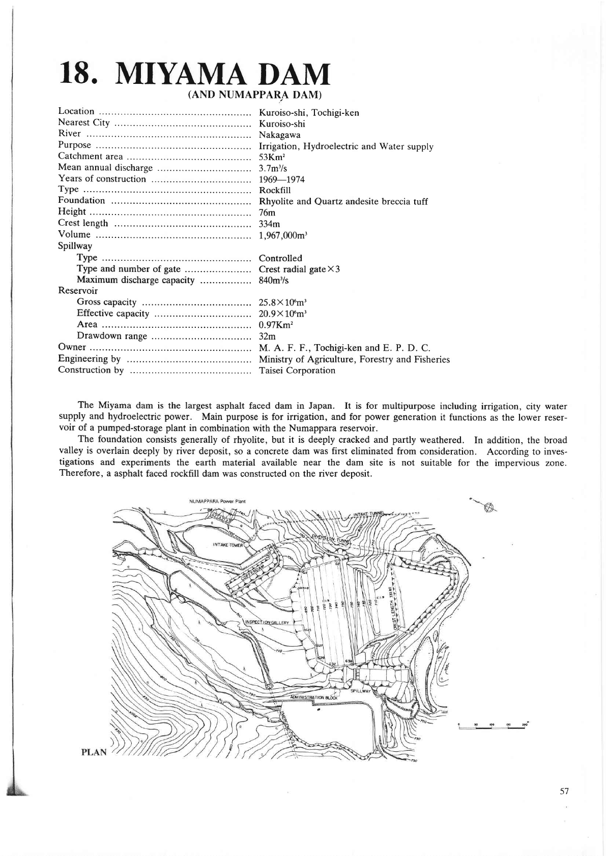
The Miyama
dam is
the
largest
asphalt fac€d dam in Japan. It is for multipurpose
including
irrigation, city
water
supply
and hydroelectric power.
Main
purpose
is for irrigation,
and for
power generation
it functions
as
the lower reser-
voir
of a
pumped-storage
plant
in
combination with the Numappara reservoir.
The foundation
consists
generally
of rhyolite, but it is deeply cracked and
partly
neathered.
In
addition, the
broad
valley
is
overlain
deeply by river deposit,
so
a
conqete
dam was first eliminated from
consideration.
According to
inves-
tigations
and experiments
the earth matedal available near the dam site is not suitable
for the impervious zone.
Therefore,
a
asphalt faced rocKill dam was
constructed
on the river deposit.
-----\
57

CROSS.
SECT ION.ASPHALT.
FAC I N G
.
CREST
LENGTH
l=3338O
TYPICAL
CROSS SECTION
-
NWLEL74880m
-
LWL
EL
72r
OO
-__l t__l,
EL 743.OO
9.o
€
58
PROFILE
ALONG
DAM
AXIS
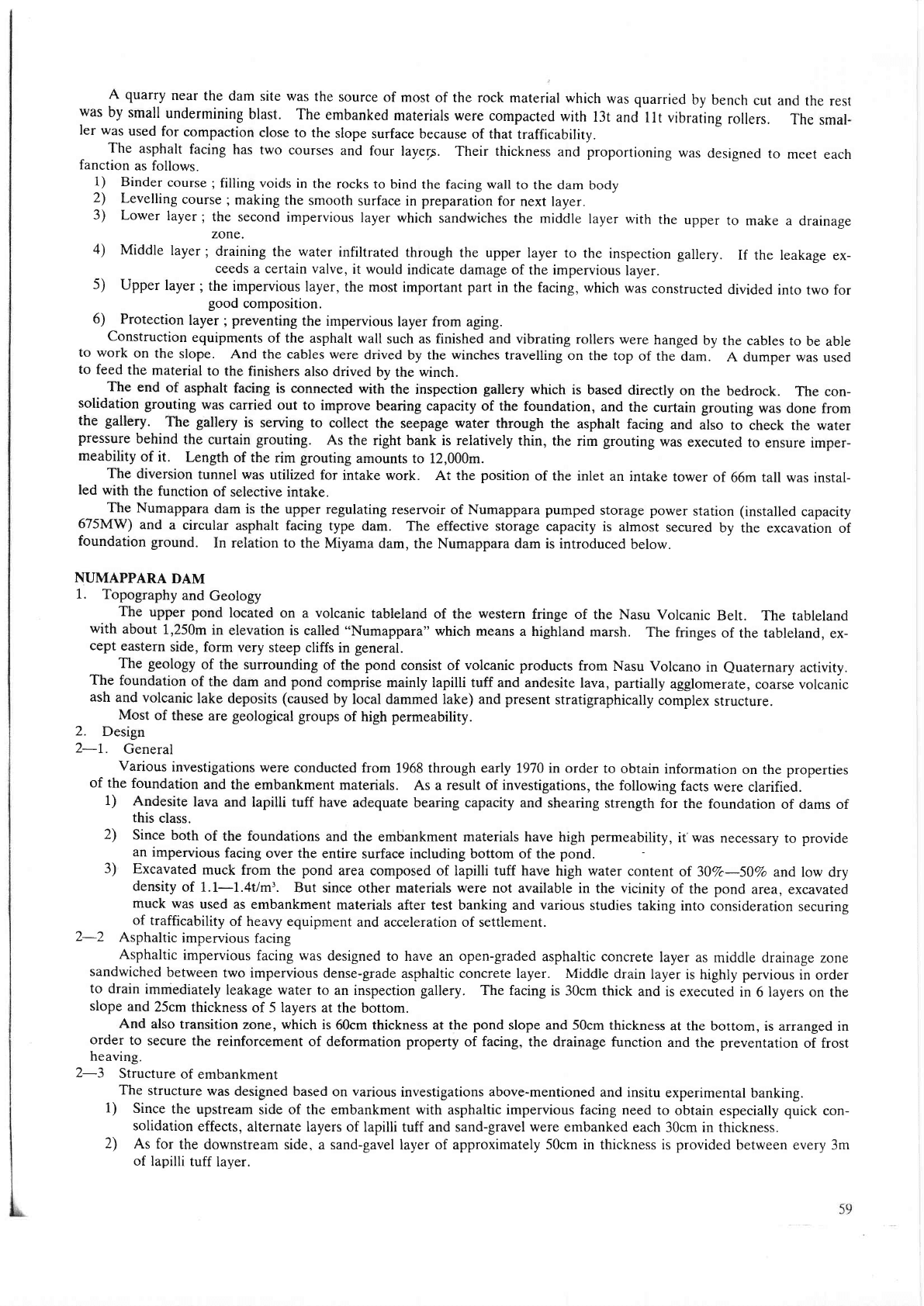
A quarry
near
the dam
site
was
the
source
of most of the rock
material which
was quarried
by
bench cut
and the
rest
was
by small
undermining
blast. The
embanked
materials were compacted
with
l3t
and
llt
vibraiing
rollers.
The
smal-
ler was
used
for compaction
close to the
slope
surface because of that
trafficability.
_
The
asphalt
facing has
two cou$es
and four
layerp. Their thickness
and
proportioning
was
designed
to meet
each
fanction
as follows.
1) Binder
course;
filling voids in
the rocks
to bind the facing wall
to the dam
body
2)
Levelling
course;making
the smooth
surface in
preparation
for next layer.
3)
Lower
layer;
the
second impervious
layer which
sandwiches the middle
layer with
the
upper
to make
a drainage
4)
Middle
layer
;
draining
the water
infiltrated
through
the upper
layer
to the
inspection
gallery.
If
the
ceeds
a certain valve,
it would
indicate damage
of the impervious
layer.
5)
Upper
layer;
the impervious
layer,
the most
important
part
in
the
facing,
which was
constructed
divided
good
composition.
6)
Protection
layer
;
preventing
the impervious
layer from aging.
Construction
equipments
of the
asphalt wall
such as finished and vibrating
rolle$ were
hanged
by the
cables to be able
to work
on
the slope.
And the cables were
drived
by the winches travelling
on the top
of the dam.
A dumper
was used
to
feed
the matedal
to the finishers
also drived by
the
winch.
_-
The
end
of
asphalt facing
is connected with
the inspection
gallery
which
is based
directly
on the bedrock.
The con-
solidation
grouting
nas carried
out to improve
bearing capacity of the
foundation, and
the curtain grouting
was
done from
the galtery.
The gatlery
is sewing to
collect the seepage water through
the asphalt
facing and
also
to iheck the water
pressure
behind
the
curtain
grouting.
As
the right bank is relatively
thin, the rim
grouting
was
executed
to ensure rmper-
meability
of it.
Length
of the rim
grouting
amounts to 12,000m.
The diversion
tunnel was utilized
for intake
work. At the
position
of the inlet
an intake
tower
of 66m tall was
instal-
led
with
the
function
of selective intake.
,__-
The Numappara
dam is the upper
regulatiog
reservoir of Numappara
pumped
storage
power
station
(installed
capacity
675MW)
and
a circular
asphalt facing
type dam. The effective storage
capacity is almost
secured
by the excavation
of
foundation
ground.
In relation to
the Miyama
dam, the Numappara dam is introduced
below.
NUMAPPARA
DAM
1.
Topography
and
Geology
The
upper
pond
located
on
a
volcanic
tableland
of the
western
with
about
1,250m
in
elevation is
called
"Numappara"
which means
a
cept
eastern
side,
form
very steep
cliffs in
general.
The
geology
of the surounding
of the
pond
consist of
volcanic products
ftom
Nasu Volcano
in
euaternary
activity.
The foundation
of
the dam and
pond
comprise mainly lapilli tuff and andesite
lava,
patially
agglomerate,
coa6e volcanic
ash
and volcanic
lake deposits
(caused
by local dammed lake) and
present
stratigraphically
complex
structure.
Most
of these
are
geological
groups
of high
permeability.
2.
Design
2-1.
General
Vadous
investigations
were conducted
from 1968 through early 1970 in order
to obtain
information
on the
properties
of the
foundation
and the embankment
materials. As a result of investigations,
the following
facts were
clarified.
1)
Andesite
lava
and lapilli tuff have
adequate bearing capacity and shearing
strength
for the foundation
of dams of
this
class.
2)
Since
both
of the foundations and
the embankment materials have
high
permeability,
it'was
necessary to
provide
an
impervious
facing over the
entire surface including bottom of
the
pond.
3)
Excavated
muck
ftom the
pond
area composed of lapilli tuff have high water
content
oI30Vc-50% and
low dry
density
of 1.1-1.4Vm3.
But
since other matedals were not available in
the
vicinity
of the
pond
area, excavated
muck
was
used as embankment
materials after test banking and various
studies taking
into consideration
securing
of trafficability
of heavy equipment
and accel€ration of settlement.
2-2
Asphaltic
impervious
facing
-
Asphaltic
imPervious
facing was
designed to have an open-graded
asphaltic mncrete
layer as
middle drainage zone
sandwiched
between
two impervious dense-grade
asphaltic conoete layer. Middle drain
layer is
highly
pervious
in
order
to drain
immediately
leakage
water to an inspection gallery. The facing
is 30cm thick
and is executed
in 6layers on the
slope
and
25cm
thickness of 5 layers at
the bottom.
And
also transition
zone, which is
@cm thickness at the
pond
slope and 50cm thickness
at the bortom,
is arranged in
order
to
secure
the reinforcement
of dcformation
property
of facing, the drainage
function and
the
preventation
of frost
heaving.
2-3
Structure
of embankment
The
structure
was
designed based on various
investigations
abovc-mentioned
and insitu
expe
mental banking.
1)
Since
the
upstream side of the embankment with
asphaltic impervious facing need
to obtain especially
quick
con-
solidation
effects, altemate Iayers
of lapilli tuff and sand-gravel
were
ernbanked each 30cm in
thickness.
2)
As for
the downstream side, a sand-gavel
layer
of approximately 50cm in thickness is
provided
between every 3m
of
lapilli tuff
laver.
leakage
ex-
into
two for
fringe
of the Nasu
Volcanic
Belt.
The tableland
highland
marsh.
The
fringes
of
the tableland,
ex-
R#
60
PLAN
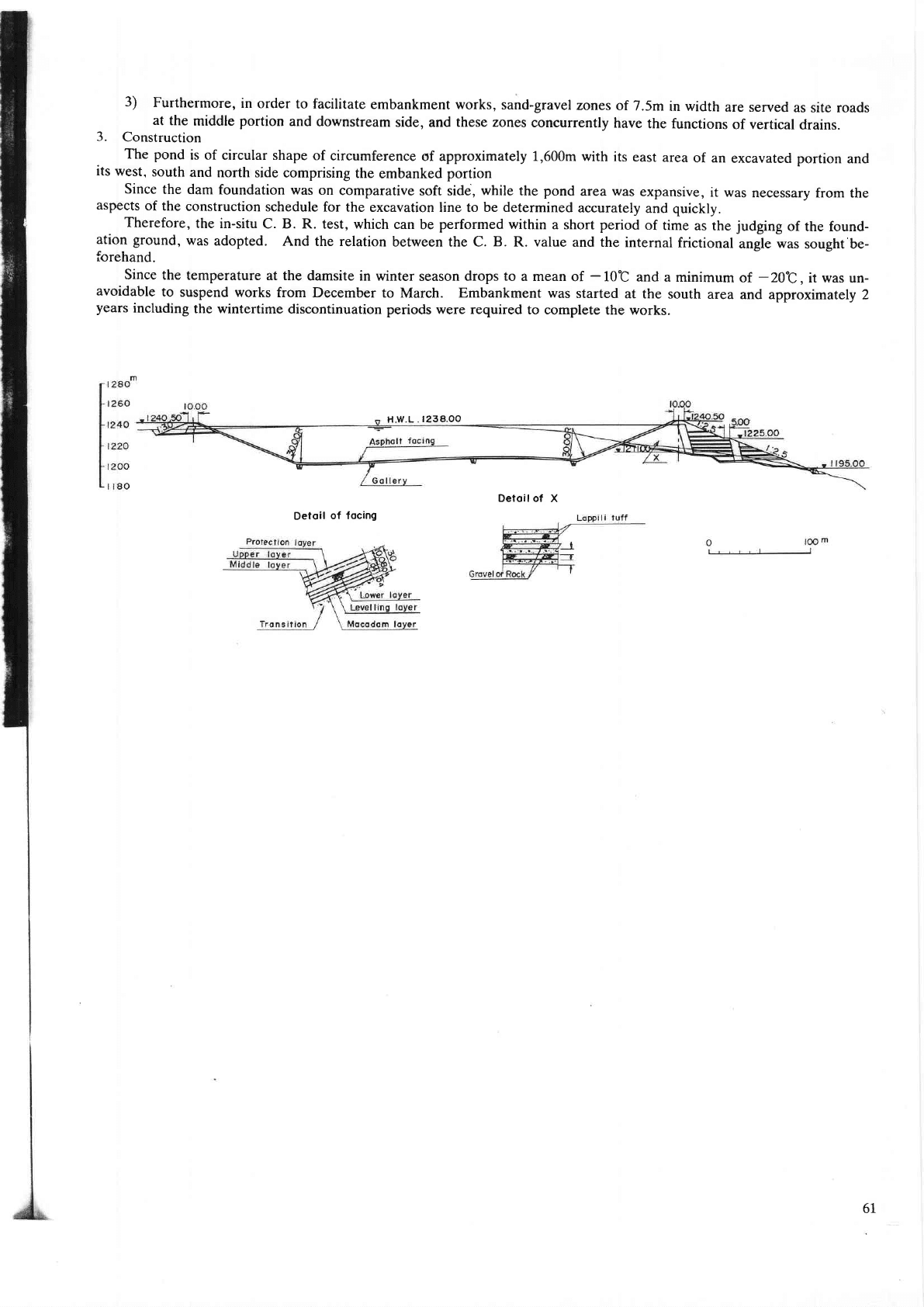
3)
Furthermore,
in
order to
facilitate
embankment works, sand-gmvel
zones
of 7.5m
in width
are served
as site roads
at the
middle portion
and downstream
side, and
these zones
concurrently
have
the functions
of vertical
drains.
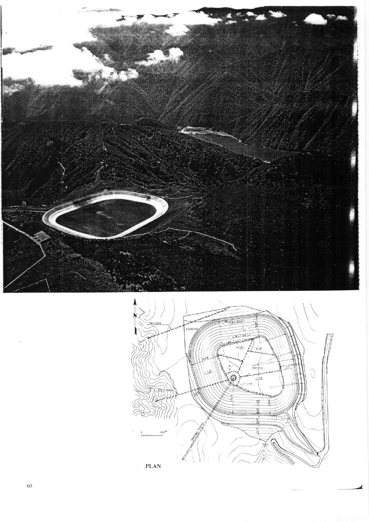
3.
Construction
The
pond
is of circular shape
of circumference
of approximately 1,6mm with
its east
area
of an excavated
Dortion
and
its
west,
south
and north
side comprising
the embanked
portion
Since
the dam
foundation was
on comparative
soft side,
while
the
pond
area
was
expansive,
it was
necessary
ftom the
aspects
of
the construction
schedule
for the excavation
line to
be determined
accurately
and
quickly.
Therefore,
the in-situ
C. B. R. test, which
can be
performed
within a short period
of
time as the
judging
of
the found-
ation ground,
was
adopted,
And the relation
between the C. B. R. value
and the internal
frictional
ansle was
sousht be-
forehand.
Since the
temperature at the
damsite in winter
season
drops to
a mean of
-
10t
and a minimum
of
-20t
,
it n'as un-
avoidable
to
suspend works
from December to
March.
Embankment was
started
at the south
area and approximately
2
years
including
the wintertime discontinuation periods
were required to complete
the works.
Detoil
of focing
H.W.L.l238.OO
Detoilof X
6l

T9.
MIZIJKT.]BO
DAM
Location
Nearest
City
.
River
Purpose
Catchment
area
Mean
annual
discharge
Years
of
construction
.
Type
Foundation
Height
Crest
length
Volume
Spillway
Type
Type
and
number
of
gate
Maximum
discharge
capacity
Reservoir
Gross
capacity
Effective
capacity
Area
Drawdown
range
Owner
Engineering
by
Construction
by
',
Yonezawa-shi,
Yamagata-ken
Yonezawa-shi
Kariyasu
Irrigation
and
Water
supply
38km'
1.3mr/s
r970-t975
Rockfill
Granite
diorite
62m
205m
1,020,000m,
Controlled
Crest
radial
gatexz
413m3/s
31.0X 10⁶m3
30.5
X
106m3
'l..7km'
40m
Ministry
of
Agriculture,
Forestry
and
Fisheries
Ditto
Kajima
Corporation
The Mizukubo
darn is
a
rockfill dam with center impervious
zone, and has a side spillway in
the left bank.
The
geology
of the
dam site
is
granite-diorite,
which is overlain
by river deposit
(sand-gravel)
in the valley, and is
weathered
deeper
at th€ higher elevation.
The weathering reaches
as much as 20m at the
top of both abutments. The
river deposit
and the weathered
rock
are
permeable
but have no
problem
in bearing capacity,
so they have been left intact
under
the dam
body except for the
portion
of the core zone.
The
sectional
profile
of the dam
is rather conservative but
the lower
part
of the upstream
filter
is
omitted
ftom the
zoning
because the matedal
is
very expensive and it is thought
that the rapid drawdown of water will not happen over th€
full
range of the
available drawdown due to furigation and
water supply
only.
For
the core material,
decomposed
granite
was used mixed
with another clayey earth in
proportion
of 25
percent.
PLAN
I
I
I
I
I
I
)
62
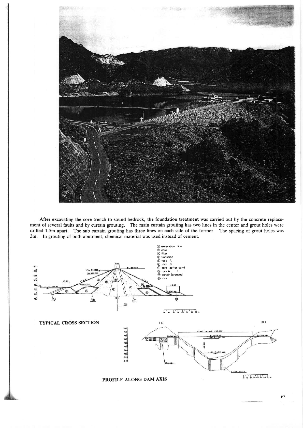
After
excavating the core trench to sound bedrock, the
foundation treatment was
carried out by the concrete replace-
ment of
several faults and by curtain
gouting.
The main curtain
grouting
has two lines in
the center and
grout
holes
were
drilled
1.5m apart.
The sub curtain
grouting
has three lines on each side of the
former.
The spacing of
grout
holes
yvas
3m. In
grouting
of both abutment, chemical material
was
used
instead of c€ment.
O
excavation
line
@
core
@
filter
@
transition
@
rock
A
@
rock B
@
core
(coffer
dam)
@rockA(
z
)
@
curtain
lgroutingl
@
rock
[-T-TTTTT]".
TYPICAL CROSS
SECTION
PROFILE
ALONG
DAM
AXIS
63
20.
NAGAI44ADO
DAM
Location
Nearest
City
.
River
Purpose
Catchment
area
Mean annual
discharge
Years of construction
Type
Foundation
Height
Crest length
Volume
Spillway
,a
Nagawa-mura,
Minamiazumi-gun,
Nagano-ken
Matsumoto-shi
Azusa
Hydroelectric
380.5Km'
21.3m'ls
1964-1969
Dome
arch
Granite
155m
355.5m
672.000m'
123x
1ffm3
94X
1ffm3
2.74Km'
55m
The
Tokyo
Electric
Power
Co-,
Inc.
Ditto
Kajima
Corporation
Type
Tunnel
Type and number
of
gate
Roller
g^texz
Maximum discharge
capacity
1.800m3/s
Reservoir
Gross capacity
Effective capacity
Area
Drawdown
range
Owner
Engineering by
Construction by
I
I
I
gso
-/
"r,
/
/----\--...\
r.@o'
t.o?5'
t.o50
.-
ttCO
'Qt,
lr)
(\,
0l
ar,
n,
\)
.()'
/17
o
A)
o
-o
U1
dl
o
PLAN
T.
DEVELOPED
UPSTREAM ELEVATION
65
TYPICAL
CROSS
SECTION
