Gregory, Derek. The colonial present: Afghanistan, Palestine, Iraq
Подождите немного. Документ загружается.


44
"The Land where Red Tulips Grew"
end of the following year the Security Council required the Taliban to turn
over bin Laden "to a country where he has been indicted" (the United
States was now the prime candidate) or face "smart sanctions" directed
at their nancial resources.28 These diplomatic maneuvrings heightened the
Taliban's sense of isolation and pushed them closer to al-Qaeda. Relations
between Omar and bin Laden warmed considerably, and al-Qaeda's pan
Islamic ideology now made considerable headway with the Taliban, who
became increasingly outspoken in their criticism of both the United States
and Saudi Arabia. None of these measures sensibly diminished the activ
ities of al-Qaeda either. On the contrary, it was almost certainly instru
mental in the terrorist attack on an American warship, the USS Cole, while
it was being refueled in Aden in October 2000. Two months later the United
Nations Security Council was even more specic in its response. It deplored
"the fact that the Taliban continues to provide safe haven to [O]sama bin
Laden and to allow him and others associated with him to operate a net
work of terrorist training camps from T aliban-controlled territory and to
use Afghanistan as a base from which to sponsor international terrorist
operations." The Taliban were required to "cease the provision of sanc
tuary and training for international terrorists," to turn over bin Laden,
and "to close all camps where terrorists are trained within the territory
under its control.,,29 But targeting bin Laden in these ways consolidated
his iconic status so that he became a larger-than-life gure for many Muslims
- even a hero - which in turn served only to increase his influence with
the T ali ban.
The Sorcerer's Apprentices
Soon after September 11, Max Boot, a features editor from the Wa ll Street
Journal, claimed that Afghanistan was "crying out for the sort of en
lightened foreign administration once provided by self-condent English
men in jodhpurs and pith helmets," and in Britain's Independent Philip
Hensher declared that Afghanistan's problem was precisely that it had never
been colonized. If only its people "had been subjugated as India was," he
sighed.30 In the face of these bugle calls from both sides of the Atlantic,
it is necessary to emphasize that the relentless destruction of �fghanistan
that I have summarized in these pages emerged out of a series of intimate
engagements with - not estrangements from - modern imperial power.
"Given to a highly decentralized and localized mode of life, the Afghani
'The Land where Red Tups Grew"
45
people have been subjected to two highly centralized state projects in the
past several decades," Mamdani observes, "Soviet-supported Marxism, then
CIA-supported Islamicization. ,,31
As I have shown, Afghanistan was as much the object of international
geopolitical maneuvrings in the late twentieth century as it had been in
the nineteenth. Both the Soviet Union and the United States treated
Afghanistan as another extra-territorial arena in which to ght the
Cold War and, as Charles Hirschkind and Saba Mahmood have argued,
Afghanistan was transformed by the role it was recruited to play: "The
vast dissemination of arms, military training, the creation of a thriving drug
trade with its attendant criminal activity, and all this in circumstances of
desperate poverty, had a radical impact on the conditions of moral and
political action for the people in the region. ,,32 By the 1990s Russia and
the United States had moved on to a new "Great Game" which the stakes
were those of political economy rather than ideology. Each maneuvered
to construct and control oil and gas pipelines from the Caspian Basin
to the Indian Ocean. They both had considerable interests in securing
Afghanistan on their own terms, and between 1994 and 1997 Russia
,
together with Iran and other central Asian states, supported the Northern
Alliance, while the United States, together with its Saudi and Pakistani allies;
tacitly supported the Taliban in an attempt to secure pipeline contracts
for a consortium involving US-based Unocal and Saudi Arabia's Delta Oil
Company.33 These involvements were abruptly terminated in 1998 when
al-Qaeda bombed US embassies in East Africa and the United States
attacked al-Qaeda bases in Afghanistan.
But what is all too easily lost from view in grand narratives of this sort
- one Great Game dissolving into another - is the multiple, conditional,
bu
t none the less powerful agency of those whose destinies these foreign
players sought to manipulate; their intrigues and interventions sustained
what Suchan dana Chatterjee calls "a consciousness that was antipathetic,
if not absolutely belligerent, towards colonial rule. ,,34 Several commenta
tors have argued that the United States unwittingly "spawned a monster"
through its entanglements: not only the Taliban but also the hydra-headed
al-Qaeda. The language of the monstrous is signicant, because colonial
imaginaries typically let monsters loose in the far-away. But we need to
remember that they also mirror metropolitan conceits. As Jasbir Puar and
Amit Rai have shown, "discourses that mobilize monstrosity as a screen
for otheess are always involved in circuits of normalizing power as well."
In this case, they tied the gure of the Islamic terrorist, through a series

46
"The Land where Red Iit/ips Grew"
of displaced racializations and sexualizations, to the counter-gure of the
white, heterosexual patriot.35 And yet, as Anthony Barnett properly re
minds us, the repugnant terrorism of al-Qaeda "was not just ap evil 'other'
that the West could triumphantly eradicate thereby vindicating its own
goodness." The fact of the matter is that "it was, and is, also our own
Frankenstein."36 The added emphasis is mine, and it carries a double charge.
The United States was indeed centrally involved in the rise of a violent
Islamicism in Afghanistan, and its connections with bin Laden and
others cannot be conveniently forgotten or wished away. But those who
think that September 11 can be laid at the door of the American political
and military establishment alone need to remember that, however great
those provocations, bin Laden and al-Qaeda were the result of more than
the American pursuit of its own "Great Game." There is certainly no
absolute opposition between "us" and "them" - the lines of liation and
connection are too complicated and too mutable for that - and, as I have
tried to show, many other threads, at once ideological and material, were
woven into the varied articulations of Islamicism. Those who enlisted in
the civil wars in Afghanistan, from inside its borders and beyond them,
were not pawns on the chessboards of the United States, Pakistan, and
Saudi Arabia, any more than those who resisted British and Russian im
perialism in the nineteenth century were pawns on Curzon's lordly chess
board. These ghters had their own agency: conditional, as I've said, but
none the less irreducible to the determinations of other states. Similarly,
the terrorism of al-Qaeda cannot be reduced to the manipulations of the
CIA (or the lSI) or the short-lived triumph of the Taliban, signicant though
each of these were. It has its own objectives, and in appealing to hundreds,
perhaps thousands, of people around the world the local and the trans
national are woven into its operations in complex and contingent ways.
4
"Civilization" and
"Barbarism"
There is no document of civilization which is not at the same time a docu
ment of barbarism.
Walter Benjamin, Theses on the Philosophy of Histo
The Visible and the Invisible
W
ITHIN hours of the attacks on New York City and Washington on
September 11 the US government named Osama bin Laden as its
prime suspect.! Nineteen young men involved in the hijacking of the four
aircraft were identied. They were all Arab nationals. None were Afghan;
most of them were Saudi citizens. They were all linked to al-Qaeda.
Faced with the sudden irruption of jihad in the heart of America - "the
homeland" - America declared its own holy war. This is no exaggeration.
The sanctuary, ev�n the sanctity, of the Republic had been breached
by the terrorist attacks. Almost immediately President George W. Bush
announced that "barbarians had declared war" on America. In the days
and weeks that followed he repeatedly described the "civilized world"
rallying to the American ag and what at rst he called its "crusade" against
transnational terrorism. It was, as he admitted later, an unfortunate
choice of words, but it was also a revealing one. For the language of the
president, his inner circle of advisers, and many media commentators was
increasingly apocalyptic. They proclaimed that America had embarked on
"a war to save civilization" that was presented as a series of Manichean

48
"Civilization" and "Barbarism "
moral absolutes: good against evil, "either you are with us or you are with
the terrorists."2 The Afghan front of this war was originally launched as
an extension of Operation Innite Reach (above, p. 43) and codenamed
Operation Innite Justice, whose eschatology also offended Muslims since
they believe that only Allah can dispense innite justice. The president con
stantly fulminated against "the Evil One" and the "evil-doers" and once
the initial assault on Afghanistan was over, in an unmistakable echo of
President Reagan's characterization of the USSR as an "evil empire," Bush
posited an extended "axis of evil" made up of "regimes that sponsor
terror": Iran, Iraq, and North Korea.3
These responses mimed the rhetoric of the Cold War with uncanny
precision. As David Campbell has shown, the Cold War mapped a series
of boundaries between "civilization" and "barbarism" whose inscriptions
had performative force. They conjured up not only an architecture of enmity
but what Campbell calls "a geography of evil." During the 2000 presi
dential election campaign, Bush had recalled growing up in a world
where there was no doubt about the identity of America's "Other." "It
was 'us' versus 'them,' and it was clear who ['they'] were," he said.
"Today, we're not so sure who the 'they' are: but we know they're
there." After September 11 Bush was sure who "they" were, and his new
found certainty - as Campbell also points out - reactivated the interpre
tative dispositions of the Cold War: "the sense of endangerment ascribed
to
all the activities of the other, the fear of internal challenge and sub
version, the tendency to militarize all responses, and the willingness to draw
the lines of superiority and inferiority between us and them. ,,4
This is hardly surprising. As Jacques Derrida notes, September 11 was,
in part, a "distant effect of the Cold War itself," and its genealogy can be
traced back to US support for the mujaheddin against the Soviet inter
vention Afghanistan.s But these are also the dispositions of colonial power,
aggrandized and emboldened, set in motion by imaginative geographies
that work silently to sever its "others" from the situations and circum
stances that shape their dispositions. This was precisely why one com
mentator questioned Bush's Manichean cartography with such passionate
lucidity:
[B]ombast about evil individuals doesn't help in understanding anything. Even
vile and murderous actions come from somewhere, and if they are extreme
in character we are not wrong to look for extreme situations. It goes not
mean that those who do them had no choice, are not answerable, far from
it. But there is sentimentality too in ascribing what we don't understand to
"Civilization" and "Barbarism"
"evil"; it lets us off the hook, it allows us to avoid the question of what, if
anying, we can recognize in the destructive act of another. If we react
out that self-questioning, we change nothing.6
49
And yet that was precisely the point of the geography of evil
- and fear
-activated by Bush's rhetoric. It was a cartography designed to bring relief
to "us" while bringing "them" into relief; at once a therapeutic and a venge
ful gesture, its object was to reveal the face of the other as other. It was,
as Stephen Bronner points out, a classic illustration of an argument
originally proposed by the deeply conservative German philosopher Carl
Schmitt, who claimed that the fundamental principle of politics was the
distinction between "us" and "them," "friend" and "enemy": the sharper
the distinction, so he believed, the more likely the success. I doubt that
Bush was aware of the intellectual lineage, but Schmitt's ghost seems to
stalk the corridors of Republican power (in several ways, as we will see),
and Bush's strategy depended on techniques of projection, hysteria, and
exaggeration that would have been familiar to Schmitt and his heirs. What
is signicant, however, is that Schmitt's writings sought to fuse political
philosophy with political theology, because Bush's Manichean map of "the
Enemy" as "Evil" cloaked its cartographers in righteousness.7 If those
who perpetrated the atrocities of September 11 could be seen as Lucif�r's
messengers, as composer Karlheinz Stockhausen suggested, those who set
themselves against formless evil were then ineluctably cast as messengers
of the divine. American troops were no longer ghting enemies; they were
casting out demons.8
This theocratic image was refracted in a thousand different ways, but
time and time again in the holy communion of the colonial present it oscil
lated between light and darkness, between the visible and the invisible.
"To this bright capital," novelist Salman Rushdie wrote from New York,
"the forces of invisibility have dealt a dreadful blow. ,,9 As Bush himself
declared, "this is a conict with opponents who believe they are invisible.
Yet they are mistaken." To demonstrate their mistake - to make them vis
ible - involved a number of different measures, and I want to consider
these in turn.
Te rritorialization, Targets, and Technoculture
The rst move was to identify al-Qaeda with Afghanistan - to fold the
one into the other - so that it could become the object of a conventional

50
"Civilization" and "Barbarism"
military campaign. This entailed two peculiar cartographic performances.
The rst was a performance of sovereignty through which the ruptured
space of Afghanistan could be simulated as a coherent state. As Simon
Dalby explains, "the cartography of violence in the places that are still
designated Afghanistan, despite the absence of most of the normal
attributes of statehood, illustrates the continuing xation of a simple
cartographic description in circumstances where sovereignty has to be
intensely simulated to render the categories of political action meaning
ful."IO The second was a performance of territory through which the
fluid networks of al-Qaeda could be xed in a bounded space. I describe
these as peculiar performances with good reason. Afghanistan was, in
Washington's terms, a "failed state," and its sovereignty was thus rendered
conditional (not least by the United States itself). And al-Qaeda is part of
a distributed network of loosely articulated groups supposedly operating in
over 40 countries, a network of networks with neither capital nor center,
so that its "radical non-territoriality" renders any conventional military
response problematic.ll And yet, if one of the most immediate consequences
of
September 11 was a visibly heightened projection of America as a national
space - closing its airspace, sealing its borders, and contracting itself to
"the homeland"12 - then its counterpart was surely the construction of a
bounded locus of transnational terrorism. The networks in which al-Qaeda
was involved, rhizomatic and capillary, were folded into the fractured
but
no less visibly bounded space of Afghanistan. It was an extraordinary
accomplishment to convince a sufcient public constituency that these
transnational terrorist networks could be rolled into the carpet-bombing
of Afghanistan. Yet to commentators like Charles Krauthamer it was
axiomatic. "The terrorists need a territorial base of sovereign protection,"
he wrote. "If bin Laden was behind this, then Afghanistan is our enemy."J3
Terry Jones followed this principle of territorialization to its absurdist,
Pythonesque conclusion: the British bombing Dublin, New York, and Boston
to wage war on the IRA.14 Derrida rehearsed the same deconstructive
argument:
The United States and Europe ... are also sanctuaries, places of training or
formation and information for all the "terrorists" of the world. No geo
graphy, no "territorial" determination is thus pertinent any longer for locat
ing the seat of these new technologies of transmission or aggression ....
The relationship berween . . . ter, territory and terror has changed, and it
is necessary to know that this is because of ... technoscience.15
"Civilization" and "Barbarism"
51
All this may be granted. But the Bush administration's territorial logic
was not an awkward miscalculation: it derived from the very idea of wag
ing
a war on terrorism. William Pfaff was right to say that "Afghanistan
has been substituted for terrorism, because Afghanistan is accessible to
military power, and terrorism is not.
,
,16 And yet even this is only part of
the answer; territorialization was more than an instrumental expediency.
Frederic Megret showed that by constructing its response to September
11 as a war on terrorism the United States necessarily co-constructed other
states as its adversaries.17 Bush's "axis of evil" projected this political geo
graphy beyond Afghanistan, and in so doing it - not incidentally - fullled
the cartographic imperatives of the neo-conservative "Project for the New
American Century." The Project had been established in 1997, and its
protagonists included key members of Bush's new administration: Vice
President Richard Cheney, Secretary of Defense Donald Rumsfeld, and
Under-Secretaries Paul Wolfowitz (Defense) and John Bolton (State).
In January 1998 the Project wrote to President Clinton urging him to
undertake political and military action aimed "at the removal of Saddam
Hussein's regime from power." The argument was restated in the
Project's Rebuilding America's Defenses (2000), which claimed that the
imperative for a substantial American military presence in the Gulf "tran
scends the issue of the regime of Saddam Hussein." The review's authors
conceded that the process of military expansion required. to secure
American global hegemony would be a long one wiout "some catastrophic
and catalyzing event -like a new Pearl Harbor.,,18 September 11 was just
that event. If Afghanistan was now, perforce, to be the rst target, it was
clear that Iraq would be the second. A territorial logic - what Neil Smith
would call the raw geography of American Empire19 - was not incidental
but integral to the historical horizon of the Project. Indeed, within 24 hours
of the attacks on New York City and Washington, Rumsfeld argued that
Iraq should be a "principal target" of the "rst round" of the war.on
terrorism. The connection between the Islamicist al-Qaeda and Saddam
Hussein's secular Ba'athist regime was stupefyingly opaque: bin Laden's
immediate response to Iraq's occupation of Kuwait had been to' offer
to raise an army of mujaheddin to repel the invaders (above, p.e 38).
Nevertheless, Bush directed the Pentagon to prepare options for an inva
sion of Iraq on the same day that he endorsed the plan for a military assault
on Afghanistan.
Within ve days of the terrorist attacks, American combat and support
aircraft had been dispatched to the Middle East and the Indian Ocean,

52
"Civilization" and "Barbarism"
and a large naval task force had put to sea. One by one, under American
pressure, all six neighboring states closed their borders with Afghanistan.
Refugees fleeing the coming conflict were trapped, and the lifelines of inter
national aid on which so many of them depended were snapped one by
one. Invoking the terms of earlier United Nations resolutions, Bush de
manded that the Taliban close all al-Qaeda training camps and hand over
its leaders. "These demands are not open to negotiation or discussion,"
he warned: "Hand over the terrorists, or suffer their fate." The Taliban
temporized; their leadership condemned the attacks on America but
insisted on evidence that bin Laden had been involved in them. On
October 7 US air strikes were launched against Kabul and Kandahar in
what Bush called "carefully targeted actions designed to disrupt the use
of Afghanistan as a base of terrorist operations, and to attack the military
capability of the Taliban regime." Two days later the Pentagon announced
that US forces had achieved "aerial supremacy" over Afghanistan (it
could have said exactly the same on September 10, of course, but brag
gadocio knows no bounds).20
These twin cartographic performances had other consequences. Much
of the work of territorialization was conducted in a technical register that
was always more than technical: it was technocultural. Advanced systems
of intelligence, interception, and surveillance were mobilized to produce
an imaginative geography of al-Qaeda and the Taliban in Afghanistan.
On October 5 a Keyhole photo-electronic satellite had been launched to
join six other imaging satellites already in orbit for the US military. The
circulation of this imagery was resicted, but not only for reasons of national
security. After reports of heavy civilian casualties in Jalalabad appeared
in the press, the US National Imagery and Mapping Agency (NIMA), which
provides combat support to the Department of Defense, bought exclusive
rights on a month-by-month basis to all commercial images of Mghanistan
taken by Ikonos-2, an advanced civilian satellite owned by Space Imaging
of Denver, whose client base included many news organizations. The re
solution level of Ikonos-2 was as much as ten times inferior to that of the
military satellites, but it could resolve objects less than 1 meter across in
black and white and 4 meters in color, which would have been sufcient
to identify bodies on the ground. While the Defense Department has the
authority to exercise shutter control over civilian satellites, any such order
is subject to legal challenge; the decision to use commercial powers to restrict
public access to the images circumvented that possibility. The spaces of
visibility constructed in this technical register were thus also spaces of
"Civilization" and "Barbarism"
53
carefully constructed invisibility, and Reporters Sans Frontieres protested
that this was censorship for political rather than military reasons.21
Throughout the rst phase of high-level aerial bombardment the con
ict remained a "war without witnesses" and its narrative progress was
punctuated less by rst-hand reporting than by long-range photography.
As joualist Maggie O'Kane put it, she and her colleagues could only "stand
on mountain tops and watch for puffs of smoke." They were denied access
to American troops in the eld "to a greater degree than in any previous
war involving US military forces," Robert Hickey reported, in large mea
sure because the Pentagon feared "that images and descriptions of civilian
bomb casualties - people already the victims of famine, poverty, drought,
oppression and brutality - would erode public support in the US and else
where in the world. ,,22 This was in striking contrast to the live, close-up
coverage of the attacks on the World Trade Center and the Pentagon itself,
and of the minute-by-minute attempts at rescue and recovery at "Ground
Zero." Involvement and engagement saturated one theater of operations;
detachment and disengagement ruled the other. The objective of news
management was to produce a space within which those held responsible
for these attacks would appear as nothing more than points on a map or
nodes in a network:: in short, as targetsY This was not conned to the
political and military'apparatus, of course. Many of these restrictions were
self-imposed by the media (or their owners), and it would be foolish
to minimize the complicity and the jingoism of many American media
organizations.24
Those most directly involved in ghting the air war were also disposed
to see Afghanistan as an abstract, de-corporealized space. Weeks before
they took to the . skies, American pilots had own virtual sorties over
"Afghanistan," a high-resolution three-dimensional computer space pro
duced through a mission rehearsal system called Topscene (Tactical
Operational Scene). It combined aerial photographs, satellite images, and
intelligence information to produce a landscape so detailed that, accord
ing to Michael Macedonia, the technical director of the US army's Simu
lation Training and Instrumentation Command, "pilots could visualize flying
from ground level up to 12,000 meters at speeds up to 2,250 km/hour,"
and plot the best approach to "designated targets." In late modern war
fare the interface between computerized simulation and computerized
mission had become so wafer-thin, he said, that from the pilot's point of
view "a real combat mission feels much like a simulated one." Zygmunt
Bauman described the likely consequences: "Remote as they are from their
54
"Civilization" and .. Barbarism "
'targets,' scurrying over those they hit too fast to witness the devastation
they cause and the blood they spi, the pilots-turned-computer-operators
hardly ever have a chance of looking their victims in the face and to
survey
the human misery they have sowed. ,,25
These are easy jibes to make from a desk, but the media did much to
conrm - and, for that matter, celebrate - their accuracy. To members of
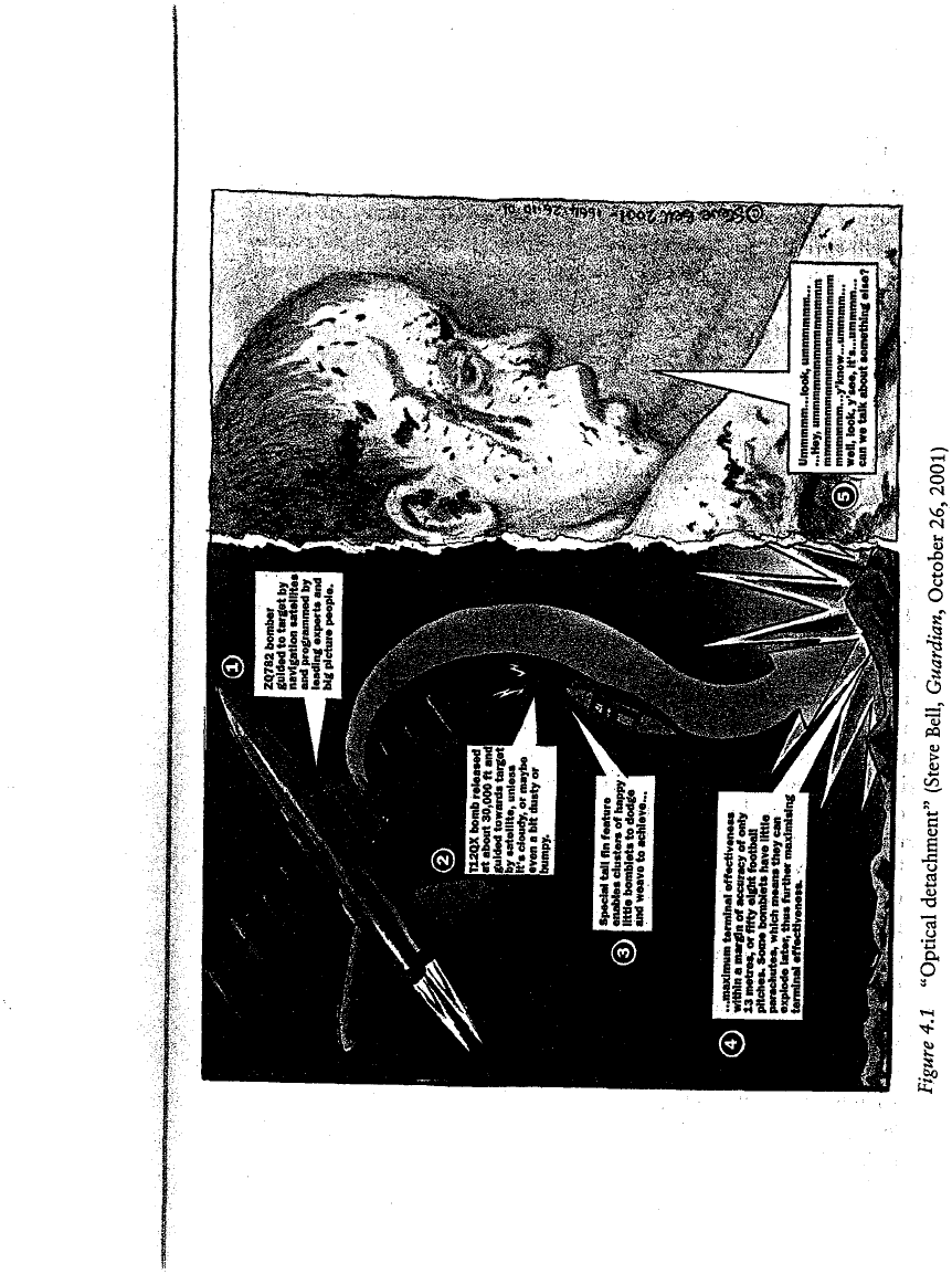
the 391st Fighter Squadron, "gods of the night sky" as Mark Bowden,
the author of Black Hawk Down, hailed them, combat was "a procedure,
deliberate and calculated, more cerebral than visceral." As they per
formed their grotesque "Kabul-ki dance" over the already eviscerated Afghan
capital, Bowden suggested that their main bodily concern was whether they
could endure such inhumanly long hours in the air without soiling them
selves. I doubt that they were so inured, at least in their private moments
of reflection. But what is signicant is the imagery that Bowden used to
represent their experience to his (primarily) American audience. Fusing
the media and the military into the promoters of a visual spectacular, his
language at once sanitized and legitimized through its own optical detach
ment, so that war seemed to become a purely technical exercise of cali
bration (gure 4.1).2
6
Modern cartographic reason, including its electronic, mediatized exten
sions, relies on these high-level, disembodied abstractions to produce the
illusion of an authorizing master-subject. It deploys both a discourse of
objectivity - so that elevation secures the higher Truth - and a discourse
of object-ness that reduces the world to a series of objects in a visual plane.
Bombs then rain down on co-ordinates on a grid, letters on a map, on
34.518611N, 69.15222 E, on K-A-B-D-L; but not on the city of Kabul,
its buildings already devastated, its population already terroriz
�
d. Ground
truth vanishes in the ultimate "God-trick," whose terrible vengeance
depends on making its objects visible and its subjects invisible. Allen Feldman
usefully brings these claims together and wires them to the imaginative
geographies of Orientalism:
Saturated areal bombing in Afghanistan ... is a new Oriental ism, the per
ceptual apparatus by which we make the eastern Other visible. Afghanis are
being held accountable for the hidden histories and hidden geographies that
are presumed to have assaulted America on September 11. . . . We· displace
our need for a transparent explanation of the World Trade Center attack
onto our panoptical bomb-sights/sites that have turned Afghanistan into an
open-air tomb of collateral damage.27

56
"Civi/itiOll " and "Barbarism ""
Bur "making the enemy visible" was more than a technoculrural achieve
ment, and it required the production and performance of other imagina
tive geographies. This became all the more urgent once the next, combined,
air and ground phase of the assault was under way and reporters and
camera-crews were able to cover the intimate effects of the war. "In order
to recognize the enemy," Slavoj Zizek explains, "one has to 'schematize'
the logical gure of the Enemy, providing it with the concrete features which
will make it into an appropriate target of hatred and struggle." And, as
he emphasizes, such recognition of "the enemy" is always at once imag
inative and performative.28 To this end, as I must now show, two main
schematics were mobilized.
Deadly Messengers
The most common gesture was to represent the terrorists as deadly mes
sengers heralding an imminent "clash of civilizations." This thesis had its
origins in an essay by Orientalist Bernard Lewis, which political scientist
Samuel Huntington had recast in a more general form.29 Huntington
argued that the question of collective identity - "Who are we?" which is
made to turn on "Who are they?" - had assumed a special force in the
contemporary world because everyday life had increasingly become sub
ject to the upheavals and uncertainties of a globalizing modernity. He saw
this question as a fundamentally cultural one whose answer was almost
invariably provided by religion. In his view, the supposedly secular world
of modernity had not triumphed over religion but, on the contrary, was
now reaping the whirlwind of "God's revenge" in the form of a global re
ligious revivalism.30 Religion was the primary basis on which Huntington
identied "seven or eight" major "civilizations" - the hesitation, Hegelian
in its condescension, was over Africa - and on which he explained the
conflicts emerging along the "fault-lines" between them. Although this
thesis was supposed to be a generalization of Lewis's polemic on "the
roots of Muslim rage," it had precisely the same destination. "The over
whelming majority of fault-line conicts," Huntington concluded, "have
taken place along the boundary looping across Eurasia and Africa that
separates Muslims from non-Muslims." This locus was neither transitory
nor contingent. It derived from what Huntington saw as "the Muslim
propensity toward violent conflict." "Wherever one looks along the peri
meter of Islam," he wrote, "Muslims have problems living peaceably with
"Civilization" and "Barbarism"
57
their neighbours." Indeed, he claimed that since the Iranian revolution in
1979 that toppled the Shah and installed an Islamicist regime in his place,
a "quasi-war" had been in progress between Islam and the West. It was,
so he said, wrong to think this was the work of a minority of "funda
mentalists" whose "use of violence is rejected by the great majority of
moderate Muslims." "This may be true," he conceded, "but evidence to
support it is lacking." Huntington's skepticism produced a chillingly
absolutist conclusion. "The underlying problem for the West is not Islamic
fundamentalism," he declared. "It is Islam, a dierent civilization whose
people are convinced of the superiority of their culture and are obsessed
with the inferiority of their power.
,,
31
These are at once extraordinary and dangerous claims. They are extra
ordinary because they erase the ways in which cultures, far from being
bounded totalities, interpenetrate and entangle with one another. Culture,
as Said has reminded us, has always been syncretic. "What culture today
has not had long, intimate, and extraordinarily rich contacts with other
culrures?" In refusing this question, Huntington reafrms the myth of
the formation of "the West" as a process of auto-production, innocent of
violence and immune fr om engagements with other cultures.32 The victims
of September 11 themselves give the lie to these claims. Even in the World
Trade Center, those murdered by al-Qaeda were not all masters of the
universe. They included "Puerto Rican secretaries, Sri Lankan cleaners,
Indian clerks and Filipino restaurant workers as well as Japanese cor
porate executives and Italian-American bond traders .... Fifteen hundred
Muslims came to pray in the building'S mosque every Friday.
,,
33 As Paul
Gilroy wrote,
The ordinary dead came from every corner and culture, north and south.
Their troubling manifestation of the south inside the north ... destabilizes
the Manichean assumptions that divide the world tidily into "us" and
"them." Under the profane and cosmopolitan constellation their trans-local
lives and ethnic affiliations construct for us, remembrance of them might
even be made to yield up a symbol of how exposure to difference, to alter
ity, can amount to rather more than the experience of loss with which
it
has been so easily and habitually associated. Their untidy, representative diver
sity might then be valued as ... a civic asset that corrupts the sham unity
of supposedly integral civilizations.34
Claims like Huntington's are also dangerous because, in proposing that
the world is riven into implacable and opposing blocs, in fabricating

58
"Civilization" and "Barbarism"
that "sham unity," they participate in a "word politics" that opens some
rhetorical spaces and closes others, which in turn prepares the ground for
the
construction of its architecture of enmity as material fact. That is, of
course, precisely why these claims are so often activated in moments of
crisis: as Shapiro puts it, they enable the state to construct "the worlds
of danger to its coherence," to conjure a menacing Other that requires its
own consolidation as a unitary and cohesive master-subject.35
the wake of September 11, this imaginative geography helped to dene
and mobilize a series of publics within which popular assent to - indeed,
a demand for - war assumed immense power. For many commentators,
the attack on America was indeed a "clash of civilizations." In an inter
view Huntington himself argued that bin Laden wanted to unleash a war
"between Islam and the West," and in a subsequent essay described the
events of September 11 as an escalation "of previous patterns of violence
involving Muslims. ,,36 Although he now connected the rise of Islamicism
to
the repressions of domestic governments and the repercussions of US
foreign policy in the Middle East, other commentators used Huntington's
repeated characterizations of Muslims and "Muslim wars" to degrade the
very idea of Islam as a civilization. To them, the Islamic world - in the sin
gular - was degenerate, a throwback to feudalism, and hence incapable
of reaching an accommodation with the modern world (no less singular
but prototypically American). This was Orientalism with a vengeance, in
which the progressive "West" was set against an immobile "Islam" that
was, if not a barbarism, then the breeding-ground of barbarians.37
For military historian Sir John Keegan, for example, Huntington did not
go far enough. He had overlooked a fundamental difference in ways of
waging war:
Westerners ght face to fa ce, in stand-up battle, and go on until one side or
the other gives in. They choose the crudest of weapons available, ·and use
them with appalling violence, but observe what to non-Westerners may well
seem curious rules of honour. Orientals, by contrast, shrink from pitched
battle, which they often deride as a sort of game, preferring ambush, sur
prise, treachery and deceit as the best way to overcome an enemy.
On September 11, he continued, the "Oriental tradition" was reasserted
with a vengeance. "Arabs, appearing suddenly out of empty space like their
desert raider ancestors, assaulted the heartlands of Western power in a
"Civilization" and "Barbarism"
59
terriing surprise raid and did appalling damage." The image of Timothy
McVeigh, who was responsible for the terrorist carnage in Oklahoma City
in 1995, as a latterday Lawrence of Arabia is hardly compelling, but in
Keegan's view the appropriate response to September 11 was to reassert
the supremacy of the "Western tradition": "to launch massive retaliation
and to persist relentlessly." He explained that the difference between the
two modes of warfare had its roots in a much deeper divide. "Peoples of
the desert and the empty spaces," Keegan insisted, do not exist on "the
same level of civilization" as those of the West (I am not making this up)
and -even as he protested that he was not deploying stereotypes - he drew
a grotesque distinction between the "predatory, destructive Orientals" (all
of them) and the "creative, productive" peoples of the West (all of them).38
Keegan's view of "Weste" warfare was not only ethnocentric; it was also
hopelessly dated. Contemporary wars are, in a vital sense, nomadic not
sedentary. Here, for example, is Zygmunt Bauman:
The new global powers rest their superiority over the settled population
on the speed of their own movement; their own ability to descend from.
nowhere without notice and vanish again without warning; their ability to
travel light and not to bother with the kind of belongings which conne the
mobility and the maneuvring potential of sedentary people.39
It is only necessary to reflect on the reluctance of the US to commit its o
troops to ground oensives -let alone "pitched battles" - in Afghanistan
and elsewhere and its reliance instead on ,spectacular bombardments'from
the air, to realize the absurdity of Keegan's characterizations.
A more sophisticated but no less rebarbative argument was advanced
in the Newsweek essay that I cited earlier, in which September 11 was
attributed to a collision between modernity and much of the Islamic
world. Zakaria (a former student of Huntington's) argued that Indonesia,
Pakistan, and Bangladesh had all "mixed Islam and modeity with
'
some
success"; after Indonesia's assault on East Timor, one wonders what
would count as failure in his vision of the world. But "for the Arab world"
- which Zakaria took to include Iran, a lazy generalization that betrayed
his misunderstanding of the cultural history of the region - "modernity
has been one failure after another." This collective inability to reach an
accommodation with modernity was made even more humiliating, so· he
said, when juxtaposed with "the success of Israel." Again, "success" was

60
"Civilization " and "Barbarism"
unquestioned: Israel's modernization has not been achieved without extra
ordinary American aid, and the Palestinian people have paid an equally
exorbitant price for that "success." But such matters were side issues to
Zakaria. As a direct result of these failures and humiliations, "in Iran, Egypt,
Syria, Iraq, Jordan, the occupied territories and the Persian Gulf" he claimed
that "the resurgence of Islamic fundamentalism is virulent, and a raw anti
Americanism seems to be everywhere." Then: "This is the land of suicide
bombers, ag-buers and ery mullahs." In one astonishing sentence
the various, vibrant cultures of the region were xed and frozen into one
diabolical landscape. One might just as easily (and accurately) say that
America is the land of serial killers, neo-Nazi militias, and Christian
fundamentalists.40
Reductive maneuvers like Zakaria's set in motion a metonymic relation
ship between territorialization and terrorism, in which each
·
endlessly
stands for the other: "terrorism" is made to mean these territories, and these
territories are made to mean terrorism. Even as Bush and his European
allies insisted that their quarrel was not with Islam, therefore, and even
as the White House worked to include Islamic states in its international
coalition and to reach out to American Muslims, "the clash of civiliza
tions" and its mutations served to conrm that America was engaged in
a
holy war against its enemy - a mirror-image of bin Laden's jihad - and
to imply that, as geographer John Agnew put it, "vice and virtue have geo
graphical addresses":
Bin Laden's is a cultural war, not an economic one. He does not worry about
the starvation of the Afghan masses among whom he lives. The economy of
the Middle East is denitely not his priority, as long as he can exploit credit
card fr aud and his inherited investments to fund his political activities. His
writings and pronouncements do not give pride of place to the Palestinian
struggle .... Bin Laden is the Samuel Huntington of the Arab world .... He
offers a mirror-image security mapping of the world to that offered by
Huntington and other prophets of the " clash of civilizations." Like the Weste
pundits, bin Laden collapses ontology into geography, the key move of the
modern geopolitical imagination.41
But this is not only or even quintessentially a modern gesture. In a video
broadcast on al-Jazeera in October 2001 bin Laden invoked the classical
Islamic distinction between the House of Islam, where Islamic govern
ments rule and Islamic law prevails, and the House of War, whose lands
are inhabited by indels. For bin Laden, the world was still divided into
"Civilization" and "Barbarism"
Figure 4.2 "The clash of fundamentalisms" (Mr Hepburn). This montage of
Bush and bin Laden was used as the cover image for Tariq Ali's The Clash of
Fundamentalisms
61
two zones: "one of faith where there is no hypocrisy, and another of
indelity." The parallels with Bush's own Manichean geography explain
why Tariq Ali was able to describe this as a "clash of fundamentalisms"
(gure 4.2). Each "perpetuates the anti-modern impulse of aggression and
reinforces the stubborn nature of cultural opposition.
,
,42

62
"Civilization" and "Barbarism"
Spaces of the Exception
The other schematic deployed to identi "the enemy" conrmed this as a
holy war, but its imaginative geography had a radically different address.
In a critical reection on the unmarked powers of democratic politics, which
was in part provoked by Schmitt's political theology, Italian philosopher
Giorgio Agamben insisted that the formation of a political community tus
not on inclusion - on "belonging" - but on exclusion. His argument
radicalizes the imaginative geographies that Said described in Orienta/ism.
In accentuating their performative force - and their coercive power -
Agamben drew attention to the gure of homo sacer ("sacred man"). Homo
sacer was a position conferred by Roman law upon those who could not
be sacriced according to ritual (because they were outside divine law: their
deaths were of no value to the gods) but who could still be killed with
impunity (because they were also outside juridical law: their lives were
of no value to their contemporaries). Agamben connects this position
to Schmitt's key claim: "Sovereign is he who decides the exception." For
Agamben, these wretched gures were subjected to a biopolitics in which
they were marked as outcasts through the operation of sovereign power.43
For my present purposes the signicance of homo sacer is threefold.
First, homo sacer emerged at the point where the law suspended itself,
its absence falling as a shadow over a zone not merely of exclusion but a
zone of abandonment that Agamben called the space of the exception. What
matters is not only those who are marginalized but also, crucially, those
who are placed beyond the margins. The exception - ex-capere - is liter
ally that which is "taken outside" and, as this suggests, it is the result of
a process of boundary promulgation and boundary perturbation. The
juridico-political ordering of space is not only a "taking of land," Agamben
continues, but above all "a 'taking of the outside,' an exception." As Andrew
Norris explains, "the [sovereign] decision and the exception it concerns
are [thus] never decisively placed within or without the legal system as
they are precisely the moving border between th e two." The mapping of
this juridico-political space requires a topology that can fold its propriety
into its perversity - a sort of Mobius strip marking "a zone of indistinc
tion" - since, in Agamben's own words, "the exception is that which can
not be included in the whole of which it is a member and cannot be a
member of the whole in which it is always already included." In effect,
homines sacri are included as the objects of sovereign power but excluded
"Civilization" and "Barbarism"
63
from being its subjects. They are the mute bearers of what Agamben calls
"bare life," deprived of language and the political life that language makes
possible.44
Secondly, this paradoxical spacing - for it is an operative act - is per
formed through relays of delegations. While "the sovereign is the one with
respect to whom all men are potentially homines sacri," Agamben insisted
that " homo sacer is the one with respect to whom all men act as sovereigns."
Their actions constantly enact a threshold that can neither be maintained
nor eliminated - "a passage that cannot be completed" - and its instan
tiation and instability are sustained through multiple iterations that reach
far beyond (and below) the pinnacle of sovereign power.45
Thirdly, as the term homo sacer implies, these spacings are sanctioned
not only by the juridical (which is thus not the only basis for sovereign
power) but also by the sacred: "an invisible imperative that inaugurates
authority." Agamben accounts for "the proximity between the sphere of
sovereignty and the sphere of the sacred" by arguing that "sacredness" is
"the originary form of the inclusion of bare life in the juridical order."
"To have exchanged a juridico-political phenomenon (homo sacer's capa
city to be killed but not sacriced) for a genuinely religious phenomenon
is," so he claims, "the root of the equivocations that have marked studies
both of the sacred and of sovereignty in our time.
,
,4
6
This is a highly abstract philosophico-historical argument, and I have
cruelly abbreviated Agamben's presentation of it. Some critics have urged
caution about its purchase - how can Roman law be made to bear on our
own times? - but in a fundamental sense this is precisely Agamben's point.
His is an argument about the metaphysics of power. My own aims are
more limited, however, and while I will refer to Agamben's arguments in
a series of concrete cases throughout e discussions that follow I make
no claims about their foundational importance (but I acknowledge that this
apparent modesty introduces its own problems). Here I want suggest,
like several other commentators, that during the assault on Afghanistan
and its aftermath - which, let me emphasize again, the alliance between
neo-conservatives and evangelical Christians validated as much by the sacred
as the juridical: America's "holy war" - Taliban ghters and al-Qaeda ter
rorists, Afghan refugees and civilians, were all regarded as homines sacri.
In November 2001 thousands of Taliban troops were captured in an
operation directed by the Fifth US Special Forces Group around Kunduz.
Four hundred of them were taken to Qala-i-Jhangi fortress on the out
skirts of Mazar-i-Sharif, a town once before and now again ruled by Abdul