Gibilisco S. Meteorology Demystified
Подождите немного. Документ загружается.

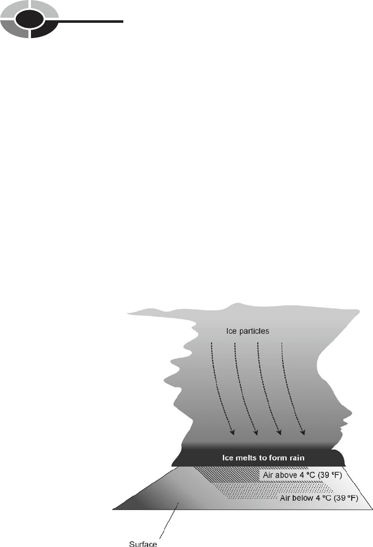
is cooler than the air near the cloud base—above freezing but below approxi-
mately 4°C (39°F)—the raindrops may refreeze before they reach the surface
(Fig. 7-1). In that case, the result is sleet.
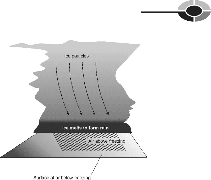
Freezing rain occurs for a different reason. The ice pellets melt as they fall,
just as they do in an ordinary rain shower. The precipitation arrives at the ground
in liquid form, but freezes as soon as it lands. Freezing rain is most likely to fall
when the temperature of the surface, and of objects at the surface, is at or below
freezing while the temperature of the air is significantly above freezing (Fig. 7-2).
In some situations, these conditions can result in a coating of ice in excess of
2.5 cm (1 in) thick on every tree, house, utility wire, automobile, and roadway.
But usually, the ice thickness is less than 1 cm (0.4 in). If the icing is significant,
the event is called an ice storm. A severe ice storm is doubly dangerous, because
it not only slickens the roads, but tree branches and utility wires often break and
fall. This can block roadways, and falling limbs may strike moving vehicles. In
an ice storm, driving should be avoided except in emergencies.
CHAPTER 7 Winter Weather
198
Fig. 7-1. When conditions favor sleet, the air temperature near the cloud base is
far enough above freezing to ensure that the precipitation falls from the
cloud as liquid, but the temperature at lower altitudes is low enough to
cause refreezing before the precipitation reaches the surface.
In the United States, the southern and eastern regions are most frequently
affected by ice storms, although the Midwest gets its share. Ice storms are less
common west of the Rockies and in the far north. A severe ice storm, followed
by a cold snap, can produce a layer of glaze that lasts for days. In 1978, an ice
storm in southern New England kept trees and utility wires coated with glaze for
a week. The effects of an ice storm are worsened if snow falls immediately
before or after the icing event. An ice storm accompanied or followed by high
winds can wreak tremendous damage to trees and utility lines.
Sleet or ice storms sometimes precede snowfalls, and sometimes follow
snowfalls. From the point of view of a motor-vehicle driver, it is better if sleet
or ice falls on top of the snow rather than underneath the snow. If the ice is on
top, the plow gets rid of the ice as well as the snow. Children prefer the ice
on top, too: they like to walk and slide on the snow without sinking in! Snow
blowers are often foiled by snow with a heavy frosting of ice on top. But for
those who shovel the stuff, it doesn’t make much difference.
CHAPTER 7 Winter Weather
199
Fig. 7-2. When conditions favor freezing rain, the surface temperature
is at or below freezing, while the air temperature remains
warm enough to allow precipitation to fall as rain.

SNOW ZONES
Much of our planet is covered by snow all the time. The highest mountain peaks,
Greenland, and the Antarctic continent are almost totally blanketed by snow all
year round. In the northern hemisphere, snow falls at least once a year over
about 50% of the land. We can draw a line around the globe, representing the
demarcation between regions where it normally snows and regions where it
doesn’t snow very often (neglecting mountain peaks). This is done by defining
areas where the average temperature is below freezing during the coldest 30-day
period of the year. The longest winters in the civilized world occur in the interi-
ors of North America, Europe, and Asia.
There are many different types of snow. In English, there is only one word for
it, but in some languages there are several. Some snow is powdery and dry, and
some is heavy and wet. Some crystals are as fine as flour, while others can stick
together to form true flakes measuring an inch or more across. The finer crystals
tend to develop when it is very cold; the large, wet flakes form at near-freezing
temperatures. For this reason, an early-winter or late-winter snow is likely to be
wet. Powdery snow falls most often in the “hard winter” months.
MOISTURE CONTENT OF SNOW
The moisture content of new-fallen snow is expressed in terms of the amount of
water after melting. For dry, fluffy, powdery snow, the water-equivalent ratio is
between 10:1 and 15:1. This means that 10 to 15 cm (4 to 6 in) of snow will melt
down to 1 cm (less than 0.5 in) of water. Wet snow has a ratio as small as 5:1.
The wet snow is not only stickier, but it is more dense. This is why a given depth
of wet snow is heavier than the same depth of dry snow.
If conditions are just right, an early-season or late-season snow storm can
cause significant damage to trees and utility lines. The effects are similar to
those of an ice storm. A particularly severe storm of this type took place in south-
ern Minnesota in March of 1966. A heavy rain changed to wet snow late one
evening. Meteorologists warned that the total snow accumulation might exceed
25 cm (10 in). The flakes piled deeper by the minute, accumulating at the rate of
more than 2.5 cm (1 in) per hour. By morning, 28 cm (about 11 in) of snow had
fallen. It clung to everything. Tree damage was extensive. The situation was
worsened by gale winds that followed the snowfall. Utility poles snapped as the
wind blew against wires coated with up to 5 cm (2 in) of sticky, dense snow. In
some locations, series of three, four, or five poles in a row were left standing
CHAPTER 7 Winter Weather
200

upside down next to their broken-off stumps, while the utility lines themselves
were unbroken!
Saturated snow can do more harm than merely damaging trees and downing
power lines. The winter of 1977–1978 produced snows so heavy in New England
that several roofs collapsed. The most sensational of all was the ruin of the Civic
Center in downtown Hartford, Connecticut. That casualty was caused by the
weight of already wet snow further saturated by rain.
Heavy, wet snow is harder to remove from roads and driveways than fluffy,
dry snow (except when blowing and drifting occurs with dry snow, constantly
foiling the efforts of snow removal crews). Wet snow chokes snowblowing
machines, making it necessary to use shovels to remove it from sidewalks
and driveways. This can cause injuries and even deaths among middle-aged and
elderly people who attempt to shovel the snow when they are “out of shape”
(have not been getting enough exercise as a routine).
PROBLEM 7-1
Why are winters in International Falls, Minnesota so much colder than
winters in Seattle, Washington, even though the two towns are at
approximately the same latitude?
SOLUTION 7-1
The Pacific Ocean moderates the temperatures in Seattle. In Seattle,
the prevailing winds come from the west, having passed over thou-
sands of kilometers of open sea before making landfall. In International
Falls, the prevailing westerlies have passed over thousands of kilome-
ters of land mass, where the air gets a chance to cool down much more
than is the case over the ocean.
PROBLEM 7-2
Some autumn seasons pass gradually into winter, while other autumn
seasons yield suddenly to winter. We’ve heard about all sorts of factors
that might affect this, such as ocean currents, sunspot cycles, and vol-
canic activity. Is there a single “prime mover” that drives cycles of
winter weather?
SOLUTION 7-2
No one knows. It is tempting to suppose that climate variations may
occur in cycles of several years or decades. But occasional “freak sea-
sons” fail to fit into any predicted pattern or cycle.
CHAPTER 7 Winter Weather
201

Anatomy and Effects
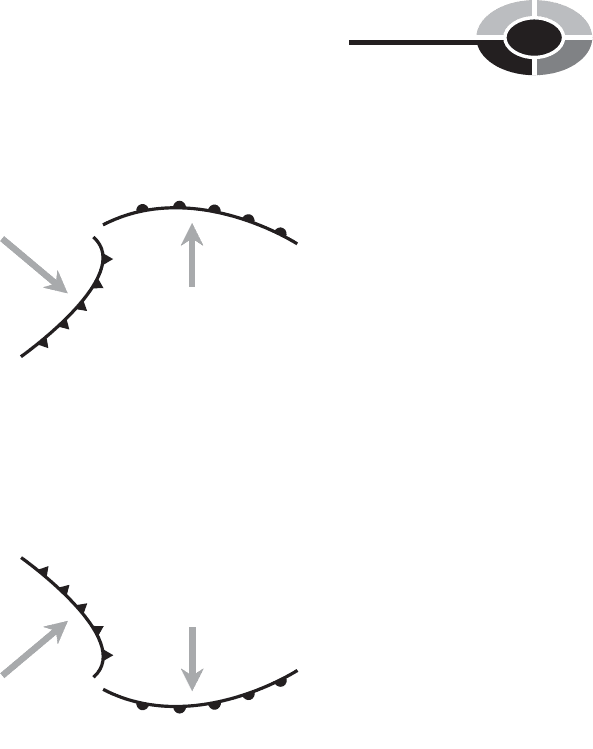
A winter storm is a low-pressure system that covers a large geographic area and
contains weather fronts. The circulation is counterclockwise in the northern
hemisphere, and clockwise in the southern hemisphere.
STORM STRUCTURE
In a typical winter storm, a cold front extends toward the equator from the cen-
ter of the system, and a warm front runs in a generally east–west direction on the
eastern side of the system. Rain usually falls between the warm and cold fronts,
except during the coldest part of the season, when it can be rain, ice pellets,
freezing rain, or snow. Behind the cold front, high winds often occur, and there
is light snow or no precipitation. It is here that blizzard conditions occasionally
arise. On the polar side of the system, snow falls. In a large storm, this is where
the heaviest accumulations take place.
Figure 7-3 shows the typical patterns for northern-hemisphere and southern-
hemisphere winter storms. In these examples, the storm tracks are generally from
west to east, although the paths of actual storms vary between compass headings
of approximately 30° (toward the north-northeast) and 150° (toward the south-
southeast). The frontal patterns shown in Fig. 7-3 are typical, but there can be
considerable variation. For example, the cold front may catch up to the warm
front near the center of the system, forming an occluded front. A second, stronger
cold front may develop behind the original one, particularly if the storm is large.
STORM FACTORS
Three primary factors determine the type of weather that accompanies a winter
storm at a given place:
•
The temperature
•
The storm orientation with respect to the locale
•
The direction of storm movement
The overall temperature dictates the relative geographical sizes of the snow
area and rain areas. Early-season and late-season storms usually have rain every-
where, except far to the poleward side of the center. Mid-season storms have
CHAPTER 7 Winter Weather
202
smaller rain areas and larger snow areas, and in some of these storms the pre-
cipitation is all snow. Latitude affects the temperature of a storm system, as does
the proximity of an ocean. Storms over land are nearly always colder than storms
over the oceans. If an ocean storm comes inland, it cools down; if a continental
storm moves out over the ocean, it warms up.
The center of a storm moving from west to east (compass heading 90°) may
pass to the north of a specific location on the surface, to the south of it, or right
over it. These three situations are shown in Fig. 7-4 for a northern-hemisphere
CHAPTER 7 Winter Weather
203
L
Warm front
Cold
front
Warm
air
Cold air
Precipitation
mainly snow
Precipitation
mainly rain
Windy
conditions
L
Warm front
Cold
front
Warm
air
Cold air
Precipitation
mainly snow
Precipitation
mainly rain
Windy
conditions
A
B
Fig. 7-3. Typical winter storm systems over land in the northern hemisphere (A)
and in the southern hemisphere (B). In both of these examples, the overall
storm movement is generally west to east (left to right in these drawings).
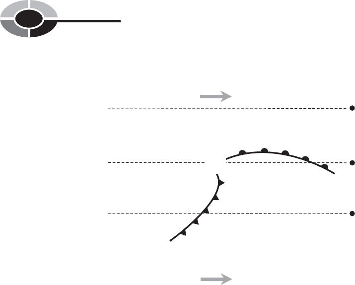
storm. Town X lies to the south of the storm track. The first precipitation will be
rain, accompanied by winds generally out of the south. As the cold front nears
and then passes, the rain will change to snow and taper off. There is a good
chance of high winds behind the cold front. Town Y lies directly in the path of
the storm. The weather there will be similar to the sequence of events at X,
except that we can expect heavier rain or snow in advance of the passage of the
center, because of the warm front. Town Z will get heavy snow, along with
winds that back from southeast to east to northeast.
The third factor that determines how a storm will behave is the direction in
which it moves. The storm of Fig. 7-4 would produce different weather at any
of the three towns shown if the movement was toward the north-northeast (com-
pass heading 30°), for example, instead of toward the east.
RAIN INTO SNOW
During a winter storm, the precipitation sometimes changes from rain to snow
as the cold front passes and the temperature drops. The wind characteristically
veers from south or southeast to west or northwest as the changeover takes place.
CHAPTER 7 Winter Weather
204
Warm front
Cold
front
Precipitation
mainly snow
Precipitation
mainly rain
Windy
conditions
L
Z
Y
X
Direction of
storm movement
Direction of
storm movement
Fig. 7-4. As a winter storm passes three different towns (X, Y, and Z), the sequence
of events in each town is determined by the part of the storm that strikes.
The rain-into-snow type of winter storm is common in the Midwest, because the
jet stream normally flows eastward or southeastward over these regions. Cold air
prevails north of the jet stream, and warm air prevails south of it. Storms tend to
track along the jet stream, usually centered slightly to its north.
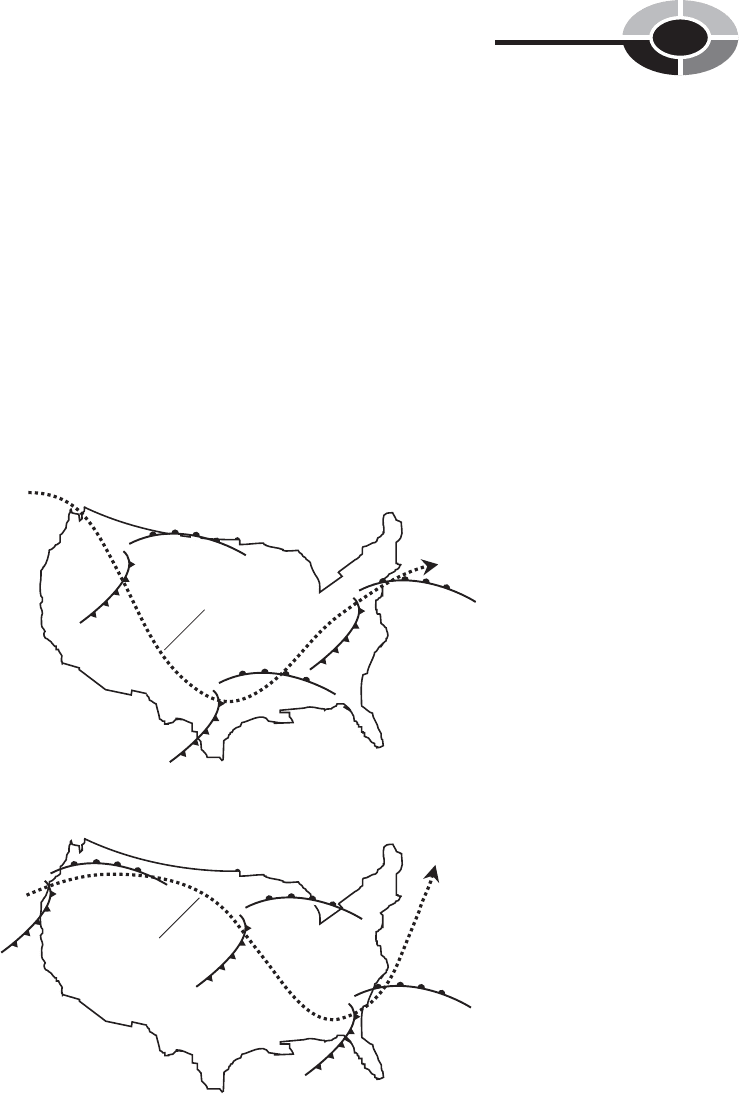
Figure 7-5 shows two typical midwinter jet stream paths over the United
States. At A, a ridge lies offshore in the Pacific, and a massive trough dominates
the center of the continent. This brings moderate weather to the west, and severe
cold in the Midwest. The Atlantic coastal area escapes the grip of the cold. At B,
a strong ridge prevails over the western United States with a deep trough over
the eastern part of the country. This results in warm, dry weather in California
and Arizona, while all of the eastern states have unusually cold conditions.
CHAPTER 7 Winter Weather
205
L
L
L
Jet
stream
L
L
L
Jet stream
A
B
Fig. 7-5. Two hypothetical wintertime jet stream patterns over the United States. At A, a central
trough; at B, a ridge in the western United States with a trough in the east.

Consider the situation in a Midwestern town, located under the jet stream or
just to the south of it as a winter storm passes. The first sign of the approaching
low-pressure system is a gradual increase in high cloudiness. The clouds first
appear as cirrus or cirrostratus, and thicken until the sky is dark and gray. The
temperature remains constant or rises slightly as the warm front passes. The wind
blows from the south or southeast. Rain falls behind the front. As the cold front
approaches, the wind veers, and the temperature drops. When the front arrives,
the temperature drops below freezing, and the rain changes to snow. Wet roads
acquire a layer of thin or patchy ice as the water on them freezes, and driving
conditions become treacherous. When the cold front moves through the area, the
wind shifts to the west or northwest and increases in speed. Visibility deterio-
rates as the snow begins blowing and drifting. If the storm system is intense,
blizzard conditions, with dangerous cold and high winds, occur. If the jet stream
pattern is similar to that shown in Fig. 7-5A, snow can fall as far south as north-
ern Mexico. If the flow is more like that of Fig. 7-5B, the Great Plains states will
be hardest hit, and snow will blanket much of the southeast.
SNOW INTO RAIN
Along the eastern seaboard during the winter, the jet stream flow is often, if not
usually, from the south-southwest or southwest toward the north-northeast or
northeast (compass heading 30° to 45°). This, along with the proximity of the
Atlantic Ocean, brings a different sequence of events to this part of the country
when a winter storm passes, as compared with the situation in the Midwest.
Suppose you are located in Connecticut as a low-pressure system follows the
jet stream path shown in Fig. 7-5A. The first signs of the storm are high clouds,
such as cirrostratus, along with an increasing easterly or northeasterly wind. The
clouds gradually become thicker and lower, and snow flurries begin. As the storm
center approaches, the winds increase, and the snow falls heavily. A strong
storm can produce gale-force winds and high tides along the coast. When the
center of the low-pressure system passes to the west and northwest of Connecticut
in the hypothetical situation of Fig. 7-5A, the wind veers to a southerly quarter,
and a warm front arrives. The temperature rises, and the precipitation changes to
mixed snow and rain, and finally it is all rain. Only in an extremely cold system
does the precipitation remain as snow following the warm front.
New England is famous for its ice storms, and the snow-into-rain scenario of
Fig. 7-5A presents ideal conditions for such an event. As the warm front passes,
all of the trees, utility lines, cars, and rooftops are still cold. If the temperature
rises from well below freezing to just above freezing, the raindrops will turn to
ice as soon as they land. Residents of New England have learned to carry cans
CHAPTER 7 Winter Weather
206

of lock de-icer in their coat pockets during the winter months. Sometimes rain
makes its way into the door lock mechanisms of a car and then freezes. Lock de-
icing compounds are available at most good auto supply stores, and they can be
used to thaw out such ice in most situations—as long as the can of de-icer is not
locked in the car!
BIG SNOW MAKERS
If the center of a low-pressure system passes off to the southeast and east of New
England, a different thing happens. A situation of this kind often develops when
the jet stream is situated in a manner similar to that shown in Fig. 7-5B. The
Atlantic waters provide a rich supply of moisture for the circulation, because
much of the storm system lies offshore. Heavy snow develops. Inland, the wind
backs from northeast to northwest.
In January 1978, an Atlantic Coast storm passed Cape Cod and then veered
out to sea. Most of New England was buried in 30 cm (1 ft) or more of snow.
Hartford got 36 cm (14 in). A few days later, another system, even more severe,
followed a similar path. Up to 1 m (39 in) of snow fell in parts of New England.
Boston received that much snow, and was also battered by winds that gusted to
80 kt (about 90 mi/h). A few whimsical people put on downhill skis and raced
along level streets, propelled by the wind. The nearby shores were inundated by
a storm surge, as if the system were a hurricane. In fact, on the satellite photos,
the storm (dubbed “Larry”) bore some resemblance to a hurricane, even show-
ing a localized eye.
As bad as it was, storm Larry could not compare with the “nor’easter” of
March 12, 1888. From Washington, D.C. to the tip of Maine, the region was
immobilized by snow accumulations of up to 1.27 m (50 in). Some drifts were
as deep as 10 m (33 ft).
Large bodies of water always increase the snow-dumping capability of a win-
ter storm. Monsters such as the “nor’easter” of 1888 and Larry of 1978 demon-
strate this well. The Atlantic Ocean, however, is not the only attractive feeding
ground for snowstorms.
LAKE-EFFECT SNOW
As the glaciers retreated during the waning centuries of the most recent ice age,
the present-day landscape was carved into the central and northern parts of
North America. The glaciers left five large freshwater lakes—the Great Lakes—
in the heart of our continent: Superior, Michigan, Huron, Erie, and Ontario. They
CHAPTER 7 Winter Weather
207