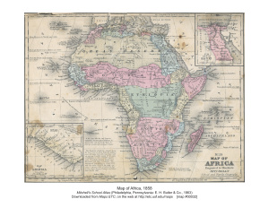
Color version / Цветной вариант.
Source: Mitchell's School Atlas (Philadelphia, Pennsylvania: E. H.
Butler & Co., 1863).
Источник: Школьный Атлас Митчелл (Филадельфия, Пенсильвания: е. Н. Батлер и Ко., 1863).
Description: Map of Africa in 1858, prior to the extensive European colonization of the continent established at the Berlin Conference of 1885. This map shows the European possessions of the Cape Colony, Natal, and Orange River Free State, and the native African States of Caffraria, Zoolus, Mozambique, Southe Africa, Lower Guinea, Ethiopia, Zanguebar, Somaulies, Abyssinia, Soudan, Upper Guinea, Liberia, Sierra Leone, Senegambia, Great Desert, Morocco, Algeria, Tunis, Tripoli, Barbary, Barca, Egypt, Bergoo or Waday, Darfur, Madagascar, and Kordofan. Ethiopia is shown as a native state in the Congo basin in central Africa.
Описание: Карта Африки, на 1858 год, до обширной Европейской колонизации континента на Берлинской конференции 1885 года. Place Names: A Complete Map of Africa, Algeria, Congo, Egypt, Ethiopia, Madagascar, Somalia, South Africa, Sudan, Cape Colony, Caffraria, Natal, Zoolus, Orange River Free State, Mozambique, Southe Africa, Lower Guinea, Ethiopia, Zanguebar, Somaulies, Abyssinia, Soudan, Upper Guine.
Топонимы: Полная карта Африки, Алжир, Конго, Египет, Эфиопия, Мадагаскар, Сомали, Южная Африка, Судан, Капская колония, Натал, Зулус, Свободное государство Оранжевой реки, Мозамбик, Нижняя Гвинея, Эфиопия, Сомали, Абиссиния, Судан, Верхняя Гвинея. Map Credit: Courtesy the private collection of Roy Winkelman.

