Richards J.A., Jia X. Remote Sensing Digital Image Analysis: An Introduction
Подождите немного. Документ загружается.

40 2 Error Correction and Registration of Image Data
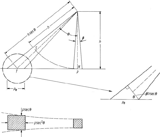
Fig. 2.7. Effect of scan angle on pixel size at constant angular instantaneous field of view
where h is altitude. Its dimension across the scan line is p sec θ. For small values
of θ these effects are negligible. For example, for Landsat 7 the largest value of θ
is approximately 7.5
◦
so that p
θ
= 1.02 p. However for systems with larger fields
of view, such as MODIS and aircraft scanners, the effect can be quite severe. For
an aircraft scanner with FOV = 80
◦
the distortion in pixel size along the scan line
is p
θ
= 1.70 p – i.e. the region on the ground measured at the extremities of the
scan is 70% larger laterally than the region sensed at nadir. When the image data is
arranged to form an image, as in Fig. 2.5, the pixels are all written as the same size
spots on a photographic emulsion or are displayed as the same pixel size on a colour
display device. Therefore the displayed pixels are equal across the scan line whereas
the equivalent ground areas covered are not. This gives a compression of the image
data towards its edges.
There is a second distortion introduced with wide field of view systems and that
relates to pixel positions across the scan line. The scanner records pixels at constant
angular increments and these are displayed on a grid of uniform centres, as in Fig. 2.5.
However the spacings of the effective pixels on the ground increase with scan angle.
For example if the pixels are recorded at an angular separation equal to the IFOV
of the sensor then at nadir the pixels centres are spaced p apart. At a scan angle θ
2.3 Sources of Geometric Distortion 41
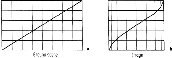
Fig. 2.8. Illustration of the along scan line compression evident in constant angular IFOV and
constant angular scan rate sensors. This leads to so-called S-bend distortion, as shown
the pixel centres will be spaced p sec
2
θ apart as can be ascertained from Fig. 2.7.
Thus by placing the pixels on a uniform display grid the image will suffer an across
track compression. Again the effect for small angular field of view systems will be
negligible in terms of the relative spacings of adjacent pixels. However when the
effect is compounded to determine the location of a pixel at the swath edge relative
to nadir the error can be significant. This can be determined by computing the arc
SN in Fig. 2.7 S being the position to which the pixel at T would appear to be
moved if the data is arrayed uniformly. It can be shown readily that SN/T N =
θ/tan θ this being the degree of across track scale distortion. In the case of Landsat 7
(θ/tan θ)
max
= 0.9936. This indicates that a pixel at the swath edge (92.5 km from
the sub-nadir point) will be 314 m out of position along the scan line compared with
the ground if the pixel at nadir is in its correct location.
These panoramic effects lead to an interesting distortion in the geometry of large
field of view systems. To see this consider the uniform mesh shown in Fig. 2.8a.
Suppose this represents a region on the ground being imaged. For simplicity the
cells in the grid could be considered to be features on the ground. Because of the
compression in the image data caused by displaying equal-sized pixels on a uniform
grid as discussed in the foregoing, the uniform mesh will appear as shown in Fig. 2.8b.
Image pixels are recorded with a constant IFOV and at a constant angular sampling
rate. The number of pixels recorded therefore over the outer grid cells in the along
scan direction will be smaller than over those near nadir. In the along track direction
there is no variation of pixel spacing or density with scan angle as this is established
by the forward motion of the platform. Rather pixels near the swath edges will contain
information in common owing to the overlapping IFOV.
Linear features such as roads at an angle to the scan direction as shown in Fig. 2.8
will appear bent in the displayed image data because of the along scan compression
effect. Owing to the change in shape caused, the distortion is frequently referred to as
S-bend distortion and can be a common problem with aircraft line scanners. Clearly,
not only linear features are affected; rather the whole image detail near the swath
edges is distorted in this manner.
42 2 Error Correction and Registration of Image Data
2.3.3
Earth Cur vature
Aircraft scanning systems, because of their low altitude (and thus the small absolute
swath width of their image data), are not affected by earth curvature. Neither are
space systems such as Landsat and SPOT, again because of the narrowness of their
swaths. However wide swath width spaceborne imaging systems are affected. For
MODIS with a swath width of 2330 km and an altitude of 705 km it can be shown
that the deviation of the earth’s surface from a plane amounts to less than 1% over the
swath, which seems insignificant. However it is the inclination of the earth’s surface
over the swath that causes the greater effect. At the edges of the swath the area of
the earth’s surface viewed at a given angular IFOV is larger than if the curvature of
the earth is ignored. The increase in pixel size can be computed by reference to the
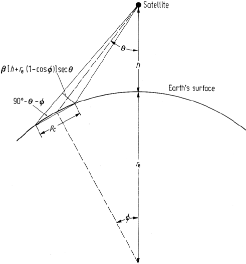
geometry of Fig. 2.9. The pixel dimension in the across track direction normal to
the direction of the sensor is β[h + r
e
(1 − cos φ)]secθ as shown. The geometry of
Fig. 2.9 then shows that the effective pixel size on the inclined earth’s surface is
p
c
= β[h + r
e
(1 − cos φ)]secθ sec(θ + φ) (2.7b)
where βh is the pixel size at nadir and φ is the angle subtended at the centre of the
earth. Note that this expression reduces to (2.7a) if φ = 0 – i.e. if earth curvature
Fig. 2.9. Effect of earth curvature on the size of a pixel in the scan direction (across track)
2.3 Sources of Geometric Distortion 43
is considered negligible. Using the NOAA satellite as an example θ = 54
◦
at the
edge of the swath and φ = 12
◦
. This shows that the effective pixel size in the along
scan direction is 2.89 times larger than that at nadir when earth curvature is ignored,
but is 4.94 times that at nadir when the effect of earth curvature is included. This
demonstrates that earth curvature introduces a significant additional compressive
distortion in the image data acquired by satellites such as NOAA when an image is
constructed on a uniform grid such as that in Fig. 2.5. The effect of earth curvature
in the along track direction is negligible.
2.3.4
Scan Time Skew
Mechanical line scanners such as the Landsat MSS and TM require a finite time to
scan across the swath. During this time the satellite is moving forward leading to a
skewing in the along track direction. As an illustration of the magnitude of the effect,
the time require to record one MSS scan line of data is 33 ms. During this time the
satellite travels forward by 213 m at its equivalent ground velocity of 6.467 km s
−1
.
As a result the end of the scan line is advanced by this amount compared with its
start.
2.3.5
Variations in Platform Altitude, Velocity and Attitude
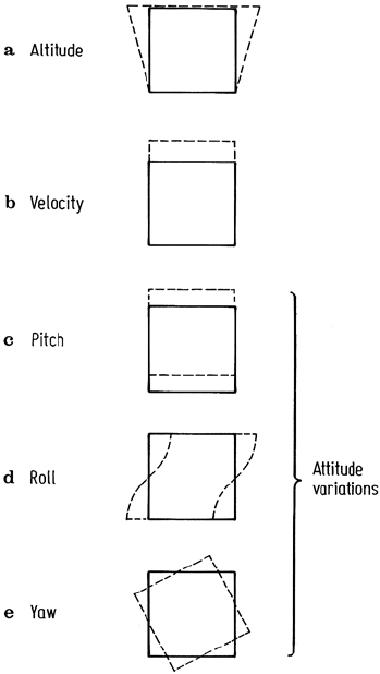
Variations in the elevation or altitude of a remote sensing platform lead to a scale
change at constant angular IFOV and field of view; the effect is illustrated in Fig. 2.10a
for an increase in altitude with travel at a rate that is slow compared with a frame
acquisition time. Similarly, if the platform forward velocity changes, a scale change
occurs in the along track direction. This is depicted in Fig. 2.10b again for a change
that occurs slowly. For a satellite platform, orbit velocity variations can result from
orbit eccentricity and the non-sphericity of the earth.
Platform attitude changes can be resolved into yaw, pitch and roll during forward
travel. These lead to image rotation, along track and across track displacement as
noted in Fig. 2.10 c–e.
While these variations can be described mathematically, at least in principle, a
knowledge of the platform ephemeris is required to enable their magnitudes to be
computed. In the case of satellite platforms ephemeris information is often teleme-
tered to ground receiving stations. This can be used to apply corrections before the
data is distributed.
Attitude variations in aircraft remote sensing systems can potentially be quite
significant owing to the effects of atmospheric turbulence. These can occur over a
short time, leading to localised distortions in aircraft scanner images. Frequently
aircraft roll is compensated for in the data stream. This is made possible by having
a data window that defines the swath width; this is made smaller than the complete
scan of data over the sensor field of view. A gyro mounted on the sensor is then used
44 2 Error Correction and Registration of Image Data
Fig. 2.10. Effect of platform position and attitude errors on the region of earth being imaged,
when those errors occur slowly compared with image acquisition
to move the position of the data window along the total scan line as the aircraft rolls.
Pitch and yaw are generally not corrected unless the sensor is mounted on a three
axis stabilized platform.
A comprehensive discussion of the nature and effects of aircraft scanner distortion
is given by Silva (1978).
2.3.6
Aspect Ratio Distortion
The aspect ratio of an image (that is, its scale vertically compared with its scale
horizontally) can be distorted by mechanisms that lead to overlapping IFOV’s. The
most notable example of this occurs with the Landsat multispectral scanner. As
discussed in Sect. A.1.2 samples are taken across a scan line too quickly compared
with the IFOV. This leads to pixels having 56 metre centres but sampled with an
IFOV of 79 m. Consequently the effective pixel size is 79 m × 56 m and thus
2.3 Sources of Geometric Distortion 45
is not square. As a result if the pixels recorded by the multispectral scanner are
displayed on the square grid of Fig. 2.5 the image will be too wide for its height when
related to the corresponding region on the ground. The magnitude of the distortion
is 79/56 = 1.411 so that this is quite a severe error and must be corrected for most
applications.
A similar distortion can occur with aircraft scanners if the velocity of the aircraft is
not matched to the scanning rate of the sensor. Either underscanning or overscanning
can occur leading to distortion in the alongtrack scale of the image.
2.3.7
Sensor Scan Nonlinearities
Line scanners that make use of rotating mirrors, such as the NOAA AVHRR and
aircraft scanners, have a scan rate across the swath that is constant, to the extent that
the scan motor speed is constant. Systems that use an oscillating mirror however,
such as the Landsat thematic mapper, incur some nonlinearity in scanning near the
swath edges owing to the need for the mirror to slow down and change directions.
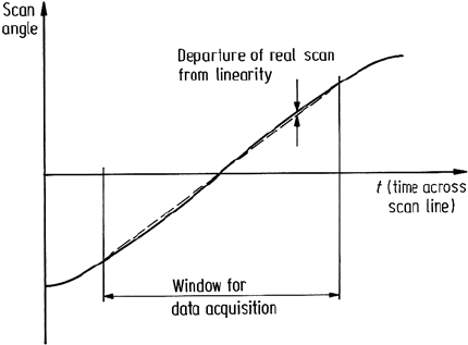
This effect is depicted in Fig. 2.11. According to Anuta (1973) this can lead to a
maximum displacement in pixel position compared with a perfectly linear scan of
about 395 m, for example, for Landsat multispectral scanner products.
Fig. 2.11. Mirror displacement versus time in an oscillating mirror scanner system. Note that
data acquisition does not continue to the extremes of the scan so that major nonlinearities are
obviated
46 2 Error Correction and Registration of Image Data
2.4
Correction of Geometric Distor tion
There are two techniques that can be used to correct the various types of geometric
distortion present in digital image data. One is to model the nature and magnitude of
the sources of distortion and use these models to establish correction formulae. This
technique is effective when the types of distortion are well characterized, such as that
caused by earth rotation. The second approach depends upon establishing mathemat-
ical relationships between the addresses of pixels in an image and the corresponding
coordinates of those points on the ground (via a map). These relationships can be
used to correct the image geometry irrespective of the analyst’s knowledge of the
source and type of distortion. This procedure will be treated first since it is the most
commonly used and, as a technique, is independent of the platform used for data
acquisition. Correction by mathematical modelling is discussed later. Before pro-
ceeding it should be noted that each band of image data has to be corrected. However
since it can often be assumed that the bands are well registered to each other, steps
taken to correct one band in an image, can be used on all remaining bands.
2.4.1
Use of Mapping Polynomials for Image Correction
An assumption that is made in this procedure is that there is available a map of the
region corresponding to the image, that is correct geometrically. We then define two
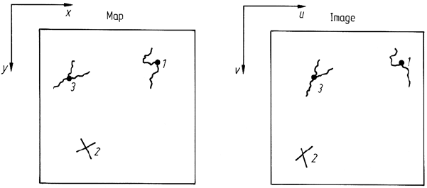
cartesian coordinate systems as shown in Fig. 2.12. One describes the location of
points in the map (x, y) and the other coordinate system defines the location of pixels
in the image (u, v). Now suppose that the two coordinate systems can be related via
a pair of mapping functions f and g so that
u = f(x,y) (2.8a)
v = g(x,y) (2.8b)
Fig. 2.12. Coordinate systems defined for the image and map, along with the specification of
ground control points
2.4 Correction of Geometric Distortion 47
If these functions are known then we could locate a point in the image knowing its
position on the map. In principle, the reverse is also true. With this ability we could
build up a geometrically correct version of the image in the following manner. First we
define a grid over the map to act as the grid of pixel centres in the corrected image.
This grid is parallel to, or indeed could in fact be, the map coordinate grid itself,
described by latitudes and longitudes, UTM coordinates and so on. For simplicity
we will refer to this grid as the display grid; by definition this is geometrically correct.
We then move over the display grid pixel centre by pixel centre and use the mapping
functions above to find the corresponding pixel in the image for each display grid
position. Those pixels are then placed on the display grid. At the conclusion of the
process we have a geometrically correct image built up on the display grid utilizing
the original image as a source of pixels.
While the process is a straightforward one there are some practical difficulties that
must be addressed. First we do not know the explicit form of the mapping functions
of (2.8). Secondly, even if we did, they may not point exactly to a pixel in the image
corresponding to a display grid location; instead some form of interpolation may be
required.
2.4.1.1
Mapping Polynomials and Ground Control Points
Since explicit forms for the mapping functions in (2.8) are not known they are
generally chosen as simple polynomials of first, second or third degree. For example,
in the case of second degree (or order)
u =a
0
+ a
1
x + a
2
y + a
3
xy + a
4
x
2
+ a
5
y
2
(2.9a)
v =b
0
+ b
1
x + b
2
y + b
3
xy + b
4
x
2
+ b
5
y
2
(2.9b)
Sometimes orders higher than three are used but care must be taken to avoid the
introduction of worse errors than those to be corrected, as will be noted later.
If the coefficients a
i
and b
i
in (2.9) were known then the mapping polynomials
could be used to relate any point in the map to its corresponding point in the image as in
the foregoing discussion. At present however these coefficients are unknown. Values
can be estimated by identifying sets of features on the map that can also be identified
on the image. These features, often referred to as ground control points (G.C.P’s),
are well-defined and spatially small and could be road intersections, airport runway
intersections, bends in rivers, prominent coastline features and the like. Enough of
these are chosen (as pairs – on the map and image as depicted in Fig. 2.12) so
that the polynomial coefficients can be estimated by substitution into the mapping
polynomials to yield sets of equations in those unknowns. Equations (2.9) show
that the minimum number required for second order polynomial mapping is six.
Likewise a minimum of three is required for first order mapping and ten for third
order mapping. In practice however significantly more than these are chosen and the
coefficients are evaluated using least squares estimation. In this manner any control
points that contain significant positional errors either on the map or in the image will
not have an undue influence on the polynomial coefficients.
48 2 Error Correction and Registration of Image Data
2.4.1.2
Resampling
Having determined the mapping polynomials explicitly by use of the ground control
points the next step is to find points in the image corresponding to each location in
the pixel grid previously defined over the map. The spacing of that grid is chosen
according to the pixel size required in the corrected image and need not be the same
as that in the original geometrically distorted version. For the moment suppose that
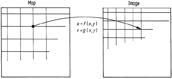
the points located in the image correspond exactly to image pixel centres. Then those
pixels are simply transferred to the appropriate locations on the display grid to build
up the rectified image. This is the case in Fig. 2.13.
Fig. 2.13. Use of the mapping polynomials to locate points in the image corresponding to
display grid positions
2.4.1.3
Interpolation
As is to be expected, grid centres from the map-registered pixel grid will not usually
project to exact pixel centre locations in the image, as shown in Fig. 2.13, and some
decision has to be made therefore about what pixel brightness value should be chosen
for placement on the new grid. Three techniques can be used for this purpose.
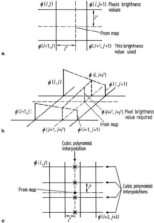
Nearest neighbour resampling simply chooses the actual pixel that has its centre
nearest the point located in the image, as depicted in Fig. 2.14a. This pixel is then
transferred to the corresponding display grid location. This is the preferred tech-
nique if the new image is to be classified since it then consists of the original pixel
brightnesses, simply rearranged in position to give a correct image geometry.
Bilinear interpolation uses three linear interpolations over the four pixels that
surround the point found in the image corresponding to a given display grid position.
The process is illustrated in Fig. 2.14b. Two linear interpolations are performed along
the scan lines to find the interpolants φ(i,j + j
) and φ(i + 1,j + j
) as shown.
2.4 Correction of Geometric Distortion 49
Fig. 2.14. Determining a display grid pixel brightness by a nearest neighbour resampling, b
bilinear interpolation and c cubic convolution interpolation; i, j etc. are discrete values of u
and v
These are given by
φ(i,j + j
) = j
φ(i,j + 1) + (1 −j
)φ(i, j )
φ(i + 1,j + j
) = j
φ(i + 1,j + 1) + (1 −j
)φ(i + 1,j)
where φ is pixel brightness and (i +i
,j+j
) is the position at which an interpolated
value for brightness is required. The position is measured with respect to (i, j) and
assumes a grid spacing of unity in both directions. The final step is to interpolate
linearly over φ(i,j + j
) and φ(i + 1,j + j
) to give
