Richards J.A., Jia X. Remote Sensing Digital Image Analysis: An Introduction
Подождите немного. Документ загружается.

1.2 Remote Sensing Platforms 9
A similar situation applies when using microwave image data; viz. several differ-
ent transmission wavelengths can be used to assist in identification of cover types by
reason of their different scattering behaviours with wavelength. However a further
data dimension is available with microwave imaging owing to the coherent nature of
the radiation used. That relates to the polarizations of the transmitted and scattered
radiation. The polarization of an electromagnetic wave refers to the orientation of the
electric field during propagation. For radar systems this can be chosen to be parallel to
the earth’s surface on transmission (a situation referred to as horizontal polarization)
or in the plane in which both the incident and scattered rays lie (somewhat inappro-
priately called vertical polarisation). On scattering, some polarization changes can
occur and energy can be received as horizontally polarized and/or vertically polar-
ized. The degree of polarization rotation that occurs can be a useful indicator of
surface material.
Another consequence of using coherent radiation in radar remote sensing sys-
tems, of significance to the interpretation process, is that images exhibit a degree
of “speckle". This is a result of constructive and destructive interference of the re-
flections from surfaces that have random spatial variations of the order of one half a
wavelength, or so. Noting that the wavelengths commonly employed in radar remote
sensing are between about 30 mm and 300 mm it is usual to find images of most
common cover types showing a considerably speckled appearance. Within a homoge-
neous region for example, such as a crop field, this causes adjacent radar image pixels
to have large differences in brightness, a factor which complicates machine-assisted
interpretation.
Finally, two radar images recorded over the same region at the same time, or
closely spaced in time, can be interfered to allow topographic detail to be revealed.
Known as InSAR (for Interferometric Synthetic Aperture Radar) the technique is
now widely used for topographic mapping (Zebker and Goldstein, 1986).
1.2
Remote Sensing Platforms
Imaging in remote sensing can be carried out from both satellite and aircraft plat-
forms. In many ways their sensors have similar characteristics although differences
in their altitude and stability can lead to very different image properties.
There are essentially two broad classes of satellite program: those satellites that sit
at geostationary altitudes above the earth’s surface and which are generally associated
with weather and climate studies, and those which orbit much closer to the earth’s
surface and that are generally used for earth surface and oceanographic observations.
Usually, the low earth orbiting satellites are in a sun-synchronous orbit, in that their
orbital plane precesses around the earth at the same rate that the sun appears to move
across the earth’s surface. In this manner the satellite acquires data at about the same
local time on each orbit.
Low earth orbiting satellites can also be used for meteorological studies. Notwith-
standing the differences in altitude, the wavebands used for the geostationary and the
10 1 Sources and Characteristics of Remote Sensing Image Data
low earth orbiting satellites, and for weather and earth observation satellites, are very
comparable. The major distinction in the image data they provide generally lies in
the spatial resolutions available. Whereas data acquired for earth resources purposes
generally has pixel sizes of less than 100 m, that used for meteorological purposes
(both at geostationary and lower altitudes) has a much coarser pixel, often of the
order of 1 km.
Appendix A provides detail on the commonly encountered geostationary and low
earth orbiting satellite programs over the past four decades or so. Included in that
Appendix are also the technical specifications of the data provided by each of their
significant imaging instruments.
The imaging technologies utilised in satellite programs have ranged from tradi-
tional cameras to mechanical scanners that record images of the earth’s surface by
moving the instantaneous field of view of the instrument across the earth’s surface
to record the upwelling energy.
Some weather satellites scan the earth’s surface using the spin of the satellite
itself while the sensor’s pointing direction is varied (at a slower rate) along the axis
of the satellite. The image data is then recorded in a raster-scan fashion not unlike
that used for the production of television pictures.
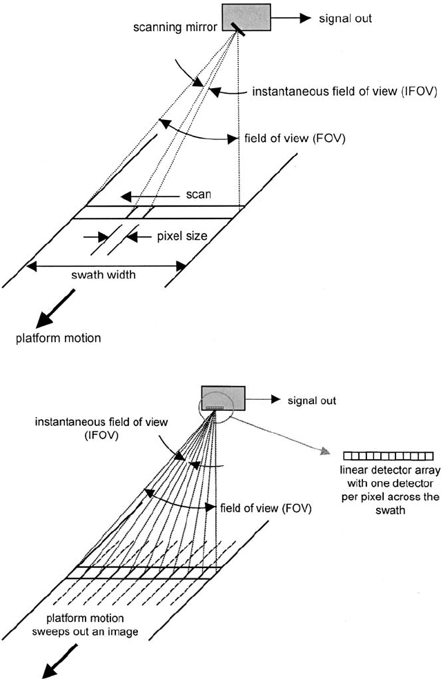
A more common image recording mechanism, used in the Landsat program,
has been to carry a mechanical scanner that records at right angles to the direction
of the satellite motion to produce raster-scans of data. The forward motion of the
vehicle then allows an image strip to be built up from the raster-scans. That process
is depicted in Fig. 1.6.
More recent technology utilises a “push-broom" mechanism in which a linear
imaging array with sufficient detectors is carried on the satellite, normal to the satel-
lite’s motion, such that each pixel can be recorded individually. The forward motion
of the satellite then allows subsequent pixels to be recorded along the satellite travel
direction in the manner shown in Fig. 1.7. As might be expected, the time over
which the energy emanating from the earth’s surface per pixel is larger with push
broom scanning than for the mechanical scanners, generally allowing finer spatial
resolutions to be achieved.
Aircraft scanners operate with essentially the same principles as those found on
satellites. Both mechanical scanners (often utilising rotating mirrors – see Appendix
A) and CCD arrays are commonly employed.
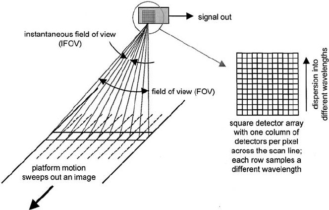
An interesting development in the past decade has been to employ rectangular
detector arrays which, in principle, could be used to capture a two dimensional
image underneath the satellite. They are normally used, however, to record pixels in
the across track direction, as with push broom scanners, with the other dimension
employed to record many spectral channels of data simultaneously. This is depicted
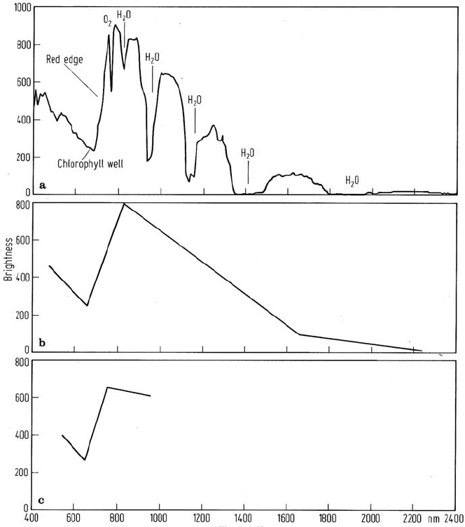
in Fig. 1.8. Often as many as 200 or so channels are recorded in this manner so that
a very good rendition of the spectra depicted in Fig. 1.3 can be obtained. As a result
the devices are often referred to as imaging spectrometers and the data described
as hyperspectral, as against multispectral when of the order of 10 wavebands are
recorded. Figure 1.9 shows the quality of the spectral data per pixel possible with an
1.2 Remote Sensing Platforms 11
Fig. 1.6. Image formation by mechanical line scanning
Fig. 1.7. Push broom line scanning in the along-track direction
12 1 Sources and Characteristics of Remote Sensing Image Data
Fig. 1.8. Use of a square detector array to achieve along-track line scanning and the recoding
of many spectral measurements simultaneously
imaging spectrometer, compared with the detail obtainable from the Landsat MSS
and TM instruments.
1.3
Image Data Sources in the Microwave Region
1.3.1
Side Looking Airborne Radar and Synthetic Aperture Radar
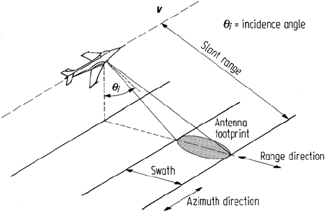
Remote sensing image data in the microwave range of wavelengths is generally
gathered using the technique of side-looking radar, as illustrated in Fig. 1.10. When
used with aircraft platforms it is more commonly called SLAR (side looking air-
borne radar), a technique that requires some modification when used from spacecraft
altitudes, as discussed in the following.
In SLAR a pulse of electrical energy at the microwave frequency (or wavelength)
of interest is radiated to the side of the aircraft at an incidence angle of θ
i
.Bythe
same principle as radars used for air navigation and shipping, some of this transmitted
energy is scattered from the ground and returned to the receiver on the aircraft. The
time delay between transmission and reflection identifies the slant distance to the
“target" from the aircraft, while the strength of the return contains information on
the so-called scattering coefficient of the target region of the earth’s surface. The
actual received signal from a single transmitted pulse consists of a continuum of
1.3 Image Data Sources in the Microwave Region 13
Fig. 1.9. Vegetation spectrum recorded by AVIRIS at 10 nm spectral sampling a, along with
equivalent TM b and MSS c spectra. In a the fine absorption features resulting from at-
mospheric constituents are shown, along with features normally associated with vegetation
spectra.
reflections from the complete region of ground actually illuminated by the radar
antenna. In Fig. 1.10 this can be identified as the range beamwidth of the antenna.
This is chosen at design to give a relation between swath width and altitude, and tends
to be rather broad. By comparison the along-track, or so-called azimuth, beamwidth is
chosen as small as possible so that the reflections from a single transmitted pulse can
be regarded as having come from a narrow strip of terrain broadside to the aircraft.
The forward velocity of the aircraft is then arranged so that the next transmitted
pulse illuminates the next strip of terrain along the swath. In this manner the azimuth
14 1 Sources and Characteristics of Remote Sensing Image Data
Fig. 1.10. Principle of side looking radar
beamwidth of the antenna defines the spatial resolution in the azimuth direction
whereas the time resolution possible between echos from two adjacent targets in the
range direction defines the spatial resolution in the slant direction.
From an image product viewpoint the slant range resolution is not of interest.
Rather it is the projection of this onto the horizontal plane as ground range resolution
that is of value to the user. A little thought reveals that the ground range resolution
is better at larger incidence angles and thus on the far side of the swath; it can be
shown that the ground range size of a resolution element (pixel) is given by
r
g
= cτ/2 sin θ
i
where τ is the length of the transmitted pulse and c is the velocity of light. (Often a
simple pulse is not used. Instead a so-called linear chirped waveform is transmitted
and signal processing on reception is used to compress this into a narrow pulse. For
the present discussion however it is sufficient to consider the transmitted waveform
to be a simple pulse or burst of the frequency of interest.)
The azimuth size of a resolution element is related to the length (or aperture) of
the transmitting antenna in the azimuth direction, l, the wavelength λ and the range
R
0
between the aircraft and the target, and is given by
r
a
= R
0
λ/l
This expression shows that a 10 m antenna will yield an azimuth resolution of 20 m
at a slant range of 1 km for radiation with a wavelength of 20 cm. However if the
slant range is increased to say 100 km – i.e. at low spacecraft altitudes – then a
20 m azimuth resolution would require an antenna of 1 km length, which clearly is
impracticable.
Therefore when radar image data is to be acquired from spacecraft, a modification
of SLAR referred to as synthetic aperture radar (SAR) is used. Essentially this utilizes
the motion of the space vehicle, during transmission of the ranging pulses, to give an
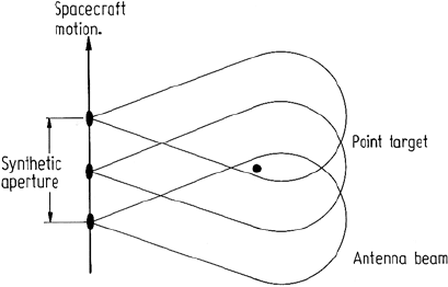
effectively long antenna, or a so-called synthetic aperture. This principle is illustrated
in Fig. 1.11, wherein it is seen that an intentionally large azimuth beamwidth is
1.4 Spatial Data Sources in General 15
Fig. 1.11. The concept of synthesizing a large antenna by utilizing spacecraft motion along
its orbital path. Here a view from above is shown, illustrating that a small real antenna is
used to ensure a large real beamwidth in azimuth. As a consequence a point on the ground is
illuminated by the full synthetic aperture
employed to ensure that a particular spot on the ground is illuminated and thus
provides reflections over a length of spacecraft travel equivalent to the synthetic
aperture required.
A discussion of the details of the synthetic aperture concept and the signal pro-
cessing required to produce a high azimuth resolution is beyond the scope of this
treatment. The matter is pursued further in Ulaby, Moore and Fung (1982), Elachi et
al. (1982), Tomiyasu (1978), and Elachi (1983, 1988).
1.4
Spatial Data Sources in General
1.4.1
Types of Spatial Data
The foregoing sections have addressed sources of multispectral digital image data.
Other sources of spatially distributed data are also often available for regions of inter-
est. These include simple maps that show topography, land ownership, roads and the
like, through to more specialised sources of spatial data such as maps of geophysical
measurements of the area. Frequently these other spatial data sources contain infor-
mation not available in multispectral imagery and often judicious combinations of
multispectral and other map-like data allow inferences to be drawn about regions on
the earth’s surface not possible when using a single source on its own. Consequently
the image analyst ought to be aware of the range of spatial data available for a region
and select that subset likely to assist in the information extraction process.
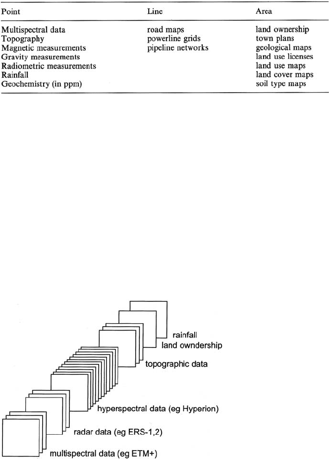
Table 1.1 is an illustration of the range of spatial data one might expect could be
available for a given region. This differentiates the data into three types according as
to whether it represents point information, line information or area information. Irre-
spective of type however, for a spatial data set to be manipulated using the techniques
16 1 Sources and Characteristics of Remote Sensing Image Data
Table 1.1. Sources of spatial data
of digital image processing it must share two characteristics with multispectral data.
First it must be available in discrete form spatially, and in value. In other words it
must consist of, or be able to be converted to, pixels with each pixel describing the
properties of a given (small) area on the ground: the value ascribed to each pixel must
be expressible in digital form. Secondly it must be in correct geographic relation to
a multispectral image data set if the two are to be manipulated together. In situa-
tions where multispectral data is not used, the pixels in the spatial data source would
normally be arranged to be referenced to a map grid. It is usual however, in digital
spatial data handling systems, to have all entries in the data set relating to a particular
geographical region, mutually registered and referenced to a map base such as the
UTM grid system. When available in this manner the data is said to be geocoded.
Means by which different data sets can be registered are treated in Sect. 2.5. Such a
database is depicted in Fig. 1.12
Fig. 1.12. An integrated spatial data source database

1.4 Spatial Data Sources in General 17
1.4.2
Data Formats
Not all sources of spatial data are available originally in the pixel oriented digital
format depicted in Fig. 1.12. Sometimes the data will be available as analog maps
that require digitisation before entry into a digital data base. That is particularly the
case with line and area data types, in which case consideration has to be given also
to the “value" that will be ascribed to a particular pixel. In line spatial data sources
the pixels could be called zero if they were not part of a line and coded to some other
number if they formed part of a line of a given type. For a road map, for example,
pixels that fall on highways might be given a value of 1 whereas those on secondary
roads could be given a value of 2, and so on. On display, the different numbers could
be interpreted and output as different colours. In a similar manner numbers can be
assigned to different regions when digitizing area spatial data sources.
Conceptually the digitization process may not be straightforward. Consider the
case for example, of needing to create a digital topographic map from its analog
contour map counterpart. Figure 1.13 illustrates this process. First it is necessary to
convert the contours on the paper map to records contained in a computer. This is
done by using an input device to mark a series of points on each contour between
which the contour is regarded by the computer to be a straight line. Information
on a contour at this stage is stored in the computer’s memory as a file of points.
This is referred to as vector format owing to the vectors that can be drawn from
point to point (in principle) to reconstruct a contour on a display. Some spatial data
handling computer systems operate in vector format entirely. However to be able to
exploit the techniques of digital image processing the vector formatted data has to
be turned into a set of pixels arranged on rectangular grid centres. This is referred
to as raster format (or sometimes grid format); the elevation values for each pixel
in the raster form are obtained by a process of interpolation over the points recorded
on the contours. The operation is referred to as vector to raster conversion and is an
essential step in entering map data into a digital spatial data base.
Raster format is a natural one for the representation of multispectral image data
since data of that type is generated by digitising scanners, is transmitted digitally and
Fig. 1.13. Definition of vector and raster format using the illustration of digitising contour
data
18 1 Sources and Characteristics of Remote Sensing Image Data
is recorded digitally. Moreover most image forming devices such as digital cameras
operate on a raster display basis, compatible with digital data acquisition and storage.
Raster format however is also appealing from a processing point of view since the
logical records for the data are the pixel values (irrespective of whether the data is
of the point, line or area type) and neighbourhood relationships are easy to establish
by means of the pixel addresses. This is important for processing operations that
involve near neighbouring groups of pixels. In contrast, vector format does not offer
this feature.
1.4.3
Geographic Information Systems (GIS)
The amount of data to be handled in a database that contains spatial sources such as
satellite and aircraft imagery along with maps, as listed in Table 1.1, is enormous, par-
ticularly if the data covers a large geographical region. Quite clearly therefore thought
has to be given to efficient means by which the data types can be stored and retrieved,
manipulated, analysed and displayed. This is the role of the geographic information
system (GIS). Like its commercial counterpart, the management information system
(MIS), the GIS is designed to carry out operations on the data stored in its database,
according to a set of user specifications, without the user needing to be knowledge-
able about how the data is stored and what data handling and processing procedures
are utilized to retrieve and present the information required. Unfortunately because
of the nature and volume of data involved in a GIS many of the MIS concepts devel-
oped for data base management systems (DBMS) cannot be transferred directly to
GIS design although they do provide guidelines. Instead new design concepts have
been needed, incorporating the sorts of operation normally carried out with spatial
data, and attention has had to be given to efficient coding techniques to facilitate
searching through the large numbers of maps and images often involved.
To understand the sorts of spatial data manipulation operations of importance in
GIS one must take the view of the resource manager rather than the data analyst.
Whereas the latter is concerned with image reconstruction, filtering, transformation
and classification, the manager is interested in operations such as those listed in
Table 1.2. These provide information from which management strategies and the
like can be inferred. Certainly, to be able to implement many, if not most, of these a
substantial amount of image processing may be required. However as GIS technology
progresses it is expected that the actual image processing being performed would be
transparent to the resource manager; the role of the data analyst will then be in part
of the GIS design. A good discussion of the essential issues in GIS will be found in
Bolstad (2002).
A problem which can arise in image data bases of the type encountered in a GIS is
the need to identify one image by reason of its similarity to another. In principle, this
could be done by comparing the images pixel-by-pixel; however the computational
demand in so doing would be enormous for images of any practical size. Instead
effort has been directed to developing codes or signatures for complete images that
will allow efficient similarity searching. For example an image histogram could be
