Richards J.A., Jia X. Remote Sensing Digital Image Analysis: An Introduction
Подождите немного. Документ загружается.

3.2 Forms of Imagery for Photointerpretation 71
It is of interest to note that the correlation matrix for the image of Fig. 3.1 is
Band 4 Band 5 Band 6 Band 7
Band 4 1.00
Band 5 0.85 1.00
Band 6 0.31 0.39 1.00
Band 7 −0.09 −0.07 0.86 1.00
wherein the redundancy present in band 6 can be seen (see Sect. 6.1).
In many ways the choice of colour assignments for the Landsat multispectral
scanner bands is an unfortunate one since this yields, for most scenes, an image
product substantially composed of reds and blues. These are the hues in which the
human visual system is least sensitive to detail. Instead it would have been better to
form an image in which yellows and greens predominate since then many fine details
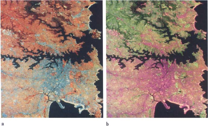
become more apparent. An illustration of this is given in Fig. 3.2.
This raises a more general point about the best use of colour image display.
Usually, when the bands are significantly correlated it is difficult to obtain richly
coloured images in which a full range of hues is present. In order to achieve good use
of the available colour space an image transformation is often required, such as the
principal components transform of Chap. 6. The discussion in Sect. 6.1.1 is relevant
in this regard.
Fig. 3.2. Standard Landsat multispectral scanner false colour composite a compared with a
product in which band 7 has been displayed as green, band 5 as red and band 4 as blue b. Finer
detail is more apparent in the second product owing to the sensitivity of the human vision
system to yellow-green hues. The image segment shown is Sydney, the capital of New South
Wales, Australia, acquired on December 14, 1980
72 3 The Interpretation of Digital Image Data
Colour composite products for other remote sensing image data sets are created,
similarly, by associating bands with display colour primaries usually in a wavelength
monotonic fashion.
3.3
Computer Processing for Photointerpretation
When image data is available in digital form it can be processed before an actual image
is produced in order to ensure that the clues used for photointerpretation are enhanced.
Little can be done about temporal clues, but judicious processing makes spectral and
spatial data more meaningful. This processing is of two types. One deals with the
radiometric (or brightness value) character of the image and is termed radiometric
enhancement. The other has to do with the image’s perceived spatial or geometric
character and is referred to as geometric enhancement. The latter normally involves
such operations as smoothing noise present in the data, enhancing and highlighting
edges, and detecting and enhancing lines. Radiometric enhancement is concerned
with altering the contrast range occupied by the pixels in an image. From the point
of view of computation, radiometric enhancement procedures involve determining
a new brightness value for a pixel (by some specified algorithm) from its existing
brightness value. They are often referred to therefore as point operations and can
be effectively implemented using look up tables. These are two-column tables that
associate a set of new brightness values with the set of old brightnesses. Specific
radiometric enhancement techniques are treated in Chap. 4.
Geometric enhancement procedures involve establishing a new brightness value
for a pixel by using the existing brightnesses of pixels over a specified neighbourhood.
The range of geometric enhancement techniques commonly used in the treatment
of remote sensing image data is given in Chap. 5. Both radiometric and geometric
enhancement can be of value in highlighting spatial information. It is generally only
radiometric or contrast enhancement, however, that amplifies an image’s spectral
character. A word of caution however is in order here. When contrast enhancement
is utilised, each feature in the data is generally treated independently. This can lead
to a loss of feature-to-feature relativity and thus, in the case of colour composites,
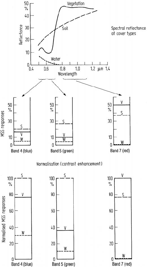
can lead to loss of colour relativity. The reason for this is depicted in Fig. 3.3, and
the effect is illustrated in Fig. 3.4.
3.4
An lntroduction to Quantitative Analysis – Classification
Identification of features in remote sensing imagery by photointerpretation is ef-
fective for global assessment of geometric characteristics and general appraisal of
ground cover types. It is, however, impracticable to apply at the pixel level unless
only a handful of pixels is of interest. As a result it is of little value for determining
3.4 An lntroduction to Quantitative Analysis – Classification 73
Fig. 3.3. Indication of how contrast enhancement can distort the feature-to-feature or band-
to-band relativity (and thus colour relativity) in an image. Without contrast enhancement both
soil and vegetation cover types would have a reddish appearance, whereas after enhancement
the soil takes on its characteristic bluish tones. The bands indicated correspond to the Landsat
MSS; the same effect will occur with similar band combinations from other sensors (eg. SPOT
bands 1, 2 and 3)

74 3 The Interpretation of Digital Image Data
Fig. 3.4. Image in which each band has identical contrast enhancement before colour com-
position a compared to that in which each band has been enhanced independently to cover its
full brightness range b. This causes a loss of band to band relativity and thus gives a different
range of hues
accurate estimates of the area in an image corresponding to a particular ground cover
type, such as the hectarage of a crop. Moreover as noted in Sect. 3.2, since photoin-
terpretation is based upon the ability of the human analyst-interpreter to assimilate
the available data, only three or so of the complete set of spectral components of
an image can be used readily. Yet there are seven bands in Landsat thematic map-
per data and many for imaging spectrometer data. It is not that all of these would
necessarily need to be used in the identification of a pixel; rather, should they all
require consideration or evaluation, then the photointerpretive approach is clearly
limited. Furthermore the human analyst is unable to discriminate to the limit of the
radiometric resolution generally available. By comparison if a computer can be used
for analysis, it could conceivably do so at the pixel level and could examine and
identify as many pixels as required. In addition, it should be possible for computer
analysis of remote sensing image data to take full account of the multidimensional
aspect of the data including its full radiometric resolution.
Computer interpretation of remote sensing image data is referred to as quantitative
analysis because of its ability to identify pixels based upon their numerical properties
and owing to its ability for counting pixels for area estimates. It is also generally called
classification, which is a method by which labels may be attached to pixels in view
of their spectral character. This labelling is implemented by a computer by having
trained it beforehand to recognise pixels with spectral similarities.
Clearly the image data for quantitative analysis must be available in digital form.
This is an advantage with image data types, such as that from Landsat, SPOT, IRS,
3.5 Multispectral Space and Spectral Classes 75
etc, as against more traditional aerial photographs. The latter require digitisation
before quantitative analysis can be performed.
Detailed procedures and algorithms for quantitative analysis are the subject of
Chaps. 8, 9 and 10; Chap. 11 is used to show how these are developed into clas-
sification methodologies for effective quantitative analysis. The remainder of this
chapter however is used to provide an outline of the essential concepts in classifi-
cation. As a start it is necessary to devise a model with which to represent remote
sensing multispectral image data in a form amenable to the development of analytical
procedures.
The material in the following section assumes that we are basing our quantitative
analysis on data described by a small number of bands – say no more than 10. For
larger numbers, as in the case of imaging spectrometers, it may be necessary to
perform feature selection first, using the procedures of Chap. 9. Otherwise, library
searching or analytical methods based on spectroscopic understanding could be used,
as discussed in Chap. 13.
3.5
Multispectral Space and Spectral Classes
The most effective means by which multispectral data can be represented in order
to formulate algorithms for quantitative analysis is to plot them in a pattern space,
or multispectral vector space, with as many dimensions as there are spectral compo-
nents. In this space, each pixel of an image plots as a point with co-ordinates given
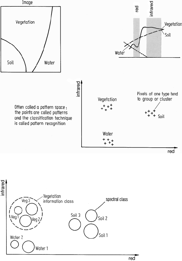
by the brightness value of the pixel in each component. This is illustrated in Fig. 3.5
for a simple two dimensional infrared versus visible red space. Provided the spectral
bands have been designed to provide good discrimination it is expected that pixels
would form groups in multispectral space corresponding to various ground cover
types, the sizes and shapes of the groups being dependent upon varieties of cover
type, systematic noise and topographic effects. The groups or clusters of pixel points
are referred to as information classes since they are the actual classes of data which
a computer will need to be able to recognise.
In practice the information class groupings may not be single clusters as depicted
in Fig. 3.5. Instead it is not unusual to find several clusters for the same region of
soil, for the same apparent type of vegetation and so on for other cover types in a
scene. These are not only as a result of specific differences in types of cover but
also result from differences in moisture content, soil types underlying vegetation
and topographic influences. Consequently, a multispectral space is more likely to
appear as shown in Fig. 3.6 in which each information class is seen to be composed
of several spectral classes.
In many cases the information classes of interest do not form distinct clusters or
groups of clusters but rather are part of a continuum of data in the multispectral space.
This happens for example when, in a land systems exercise, there is a gradation of
canopy closure with position so that satellite or aircraft sensors might see a gradual
variation in the mixture of canopy and understory. The information classes here might
76 3 The Interpretation of Digital Image Data
Fig. 3.5. Illustration of a two dimensional muItispectral space showing its relation to the
spectral reflectance characteristics of ground cover types
Fig. 3.6. Representation of information classes by sets of spectral classes
correspond to nominated percentage mixtures rather than to sets of well defined sub-
classes as depicted in Fig. 3.6. It is necessary in situations such as this to determine
appropriate sets of spectral classes that represent the information classes effectively.
This is demonstrated in the exercises chosen in Chap. 11.
3.6 Quantitative Analysis by Pattern Recognition 77
In quantitative analysis it is the spectral classes that a computer will be asked
to work with since they are the “natural" groupings or clusters in the data. After
quantitative analysis is complete the analyst simply associates all the relevant spec-
tral classes with the one appropriate information class. In the context of the most
commonly adopted approach to classification, based on statistical models, spectral
classes will be seen to be unimodal probability distributions and information classes
as possible multimodal distributions. The latter need to be resolved into sets of single
modes for convenience and accuracy in analysis.
3.6
Quantitative Analysis by Pattern Recognition
3.6.1
Pixel Vectors and Labelling
Recognition that image data exists in sets of spectral classes, and identification of
those classes as corresponding to specific ground cover types, is carried out using
the techniques of mathematical pattern recognition or pattern classification and their
more recent machine learning variants. The patterns are the pixel themselves, or
strictly the mathematical pixel vectors that contain the sets of brightness values for
the pixels arranged in column form:
x =
⎡
⎢
⎢
⎢
⎣
x
1
x
2
.
.
.
x
N
⎤
⎥
⎥
⎥
⎦
where x
1
to x
N
are the brightnesses of the pixel x in bands 1 to N respectively. It is
simply a mathematical convention that these are arranged in a column and enclosed
in an extended square bracket. A summary of essential results from the algebra used
for describing and manipulating these vectors is given in Appendix D.
Classification involves labelling the pixels as belonging to particular spectral
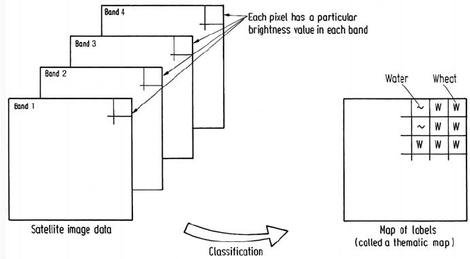
(and thus information) classes using the spectral data available. This is depicted as a
mapping in Fig. 3.7. In the terminology of statistics this is more properly referred to
as allocation rather than classification. However throughout this book, classification,
categorization, allocation and labelling are generally used synonomously.
There are two broad classes of classification procedure and each finds application
in the analysis of remote sensing image data. One is referred to as supervised clas-
sification and the other unsupervised classification. These can be used as alternative
approaches but are often combined into hybrid methodologies as demonstrated in
Chap. 11.
78 3 The Interpretation of Digital Image Data
Fig. 3.7. The role of classification in labelling pixels in remote sensing image data
3.6.2
Unsupervised Classification
Unsupervised classification is a means by which pixels in an image are assigned to
spectral classes without the user having foreknowledge of the existence or names of
those classes. It is performed most often using clustering methods. These procedures
can be used to determine the number and location of the spectral classes into which
the data falls and to determine the spectral class of each pixel. The analyst then
identifies those classes afterwards by associating a sample of pixels in each class
with available reference data, which could include maps and information from ground
visits. Clustering procedures are generally computationally expensive yet they are
central to the analysis of remote sensing imagery. While the information classes for
a particular exercise are known, the analyst is usually totally unaware of the spectral
classes, or sub-classes as they are sometimes called. Unsupervised classification is
therefore useful for determining the spectral class composition of the data prior to
detailed analysis by the methods of supervised classification.
The range of clustering algorithms frequently used for determination of spectral
classes and for unsupervised classification is treated in Chap. 9.
3.6.3
Supervised Classification
Before proceeding, it is important to recognise that a range of supervised classifica-
tion procedures is possible. In the following we concentrate on a statistical method-
ology that has been the mainstay of quantitative analysis since the 1970s. Other
methods are based on non-statistical, geometric techniques that seek to place sepa-
rating surfaces between the classes shown in Figs. 3.5 and 3.6. Chapter 8 treats both
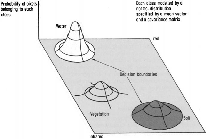
3.6 Quantitative Analysis by Pattern Recognition 79
Fig. 3.8. Two dimensional multispectral space with the spectral classes represented by Gaus-
sian probability distributions
statistical and geometric supervised classification in detail, using the material in the
following as an introduction to the concepts involved.
An important assumption in statistical supervised classification usually adopted in
remote sensing is that each spectral class can be described by a probability distribution
in multispectral space: this will be a multivariable distribution with as many variables
as dimensions of the space. Such a distribution describes the chance of finding a
pixel belonging to that class at any given location in multispectral space. This is
not unreasonable since it would be imagined that most pixels in a distinct cluster
or spectral class would lie towards the centre and would decrease in density for
positions away from the class centre, thereby resembling a probability distribution.
The distribution found to be of most value is the normal or Gaussian distribution.
It gives rise to tractable mathematical descriptions of the supervised classification
process, and is robust in the sense that classification accuracy is not overly sensitive
to violations of the assumptions that the classes are normal. A two dimensional
multispectral space with the spectral classes so modelled is depicted in Fig. 3.8. The
decision boundaries shown in the figure represent those points in multispectral space
where a pixel has equal chance of belonging to two classes. The boundaries therefore
partition the space into regions associated with each class; this is developed further
in Sect. 8.2.4.

80 3 The Interpretation of Digital Image Data
A multidimensional normal distribution is described as a function of a vector
location in multispectral space by:
p(x) =
1
(2π)
N/2
|Σ|
1/2
exp{−
1
2
(x − m)
t
Σ
−1
(x − m)}
where x is a vector location in the N dimensional pixel space: m is the mean position
of the spectral class – i.e. the position x at which a pixel from the class is most likely
to be found, and Σ is the covariance matrix of the distribution, which describes
its spread directionally in the pixel space. Equation (6.2) shows how this matrix is
defined;Appendix E summarises some of the important properties of this distribution.
The multidimensional normal distribution is specified completely by its mean
vector and its covariance matrix. Consequently, if the mean vectors and covariance
matrices are known for each spectral class then it is possible to compute the set of
probabilities that describe the relative likelihoods of a pattern at a particular location
belonging to each of those classes. It can then be considered as belonging to the class
which indicates the highest probability. Therefore if m and Σ are known for every
spectral class in an image, every pixel in the image can be examined and labelled
corresponding to the most likely class on the basis of the probabilities computed
for the particular location for a pixel. Before that classification can be performed
however m and Σ are estimated for each class from a representative set of pixels,
commonly called a training set. These are pixels which the analyst knows as coming
from a particular (spectral) class. Estimation of m and Σ from training sets is referred
to as supervised learning. Supervised classification consists therefore of three broad
steps. First a set of training pixels is selected for each spectral class. This may be
done using information from ground surveys, aerial photography, topographic maps
or any other source of reference data. The second step is to determine m and Σ for
each class from the training data. This completes the learning phase. The third step is
the classification phase, in which the relative likelihoods for each pixel in the image
are computed and the pixel labelled according to the highest likelihood.
The view of supervised classification adopted here has been based upon an as-
sumption that the classes can be modelled by probability distributions and, as a
consequence, are described by the parameters of those distributions. As a result it
is also referred to as a parametric supervised method. Other supervised techniques
also exist, in which neither distribution models nor parameters are relevant. These
are referred to as non-parametric methods. More recently, neural networks and sup-
port vector machine non-parametric classification methods have been shown to offer
promise in remote sensing applications, as demonstrated in Sects. 8.9.1 and 8.9.2.
References for Chapter 3
A good summary, with extensive references, of the spectral reflectance characteristics of
common earth surface cover types has been given by Hoffer (1978). Material of this type is
important in photointerpretation. Landgrebe (1981) and Hoffer (1979) have provided good
general discussions on computer classification of remote sensing image data.
