Karimi H.A. Universal Navigation on Smartphones
Подождите немного. Документ загружается.

90
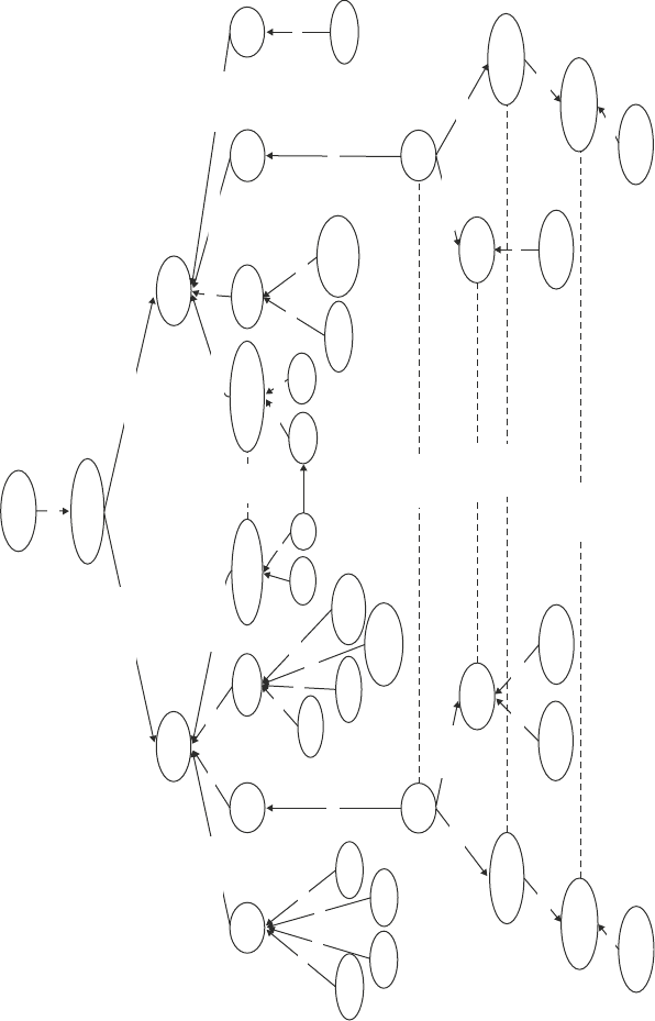
Fig. 5.1 Anywhere ontology
User
requests
Navigation
employed-in
employed-in
Indoor
Outdoor
represent
represent
mode-of
localization of
Mobility
Geopositioning
switch
localizaion-of
mode-of
represent
Scale
Model
is-a
is-a
is-a
is-a
is-a
is-a
is-ais-a
is-a
is-a
is-a
is-a
is-a
is-a
is-a
is-a
is-a
is-a
is-a
is-a
is-a
is-a
Scale
Model
GPS
DR
Wi-Fi
RFID
Geopositioning
Mobility
represent
Country
State
City
Town
GIS
Walking
Walking
Driving
Riding
Bike
Riding
Wheelchair
switch
switch
switch
switch
Riding
Wheelchair
Building
CAD
contains
includes
Netrwork
Map Data
representated-in
Coordinate
System
Geographic
Sidewalk
Road
include
contain
Map Data
representated-in
Hallway
Coordinate
System
Cartisian
Network
5 Anywhere Navigation
91
With respect to user’s request for navigation assistance in outdoor, the concept of
“outdoor” contains four sub-concepts: mobility, geo-positioning, model, and scale.
The “mobility” sub-concept, which is related to the “outdoor” concept through the
“mode-of’ relation, is for different modes of travel a user may request for outdoor
navigation which could be “walking”, “driving”, “riding wheelchair”, or “riding
bike”, all through the “is-a” relation. The “geo-positioning” concept is related to
the “outdoor’ concept through the “localization-of” relation and is for different geo-
positioning sensors which are possible for outdoor navigation including GPS and
DR, each related to “geo-positioning” through the “is-a” relation. The “model” sub-
concept that is related to the “outdoor” concept through the “represent” relation
is for the type of data required for outdoor navigation which is dominantly “GIS”
and is related to the “model” sub-concept through the “is-a” relation. The data in
the “GIS” model includes “network” which, through the “is-a” relation, could be
“road” or “sidewalk”. The “GIS” model contains “map data” for navigation that can
be represented in “coordinate system” through the “represented-in” relation which
is a (through the “is-a” relation) “geographic” coordinate system. The “scale” sub-
concept that is related to the “outdoor” concept through the “represent” relation is
for the geographic extent within which outdoor navigation is requested and could be
“country”, “state”, “city”, or “town”, all related to the “scale” sub-concept through
the “is-a” relation.
With respect to user’s request for navigation assistance in indoor, the concept of
“indoor” contains four sub-concepts: mobility, geo-positioning, model, and scale.
The “mobility” sub-concept which is related to the “indoor” concept through the
“mode-of” relation is for different modes of travel a user may request for indoor
navigation which could be “walking” or “riding wheelchair”, both through the “is-
a” relation. The “geo-positioning” sub-concept which is related to the “indoor” con-
cept through the “localization-of” relation is for different geo-positioning sensors
that are possible in indoor navigation including RFID and Wi-Fi, each related to
“geo-positioning” through the “is-a” relation. The “model” sub-concept, which is
related to the “indoor” concept is for the type of data required for indoor navigation
which is dominantly “CAD” and is related to the “model” sub-concept through the
“is-a” relation. The data in the “CAD” model includes “network” which, through
the “is-a” relation is “hallway”. The “CAD” model contains “map data” for naviga-
tion that can be represented in “coordinate system” through the “represented-in”
relation, which is a (through the “is-a” relation) “Cartesian” coordinate system. The
“scale” sub-concept that is related to the “indoor” concept through the “represent”
relation is for the geographic extent within which indoor navigation is requested
and can be “building” related to the “scale” sub-concept through the “is-a” relation.
The ontology also represents knowledge about the sub-concepts in the “outdoor”
and “indoor” concepts that must be switched when transition from one environment
to the other is considered; the dashed lines in the diagram (Figure 5.1) show the
sub-concepts in the corresponding environments that must be switched. These sub-
concepts are “geo-positioning” in both outdoor and indoor navigation and “GIS”
in outdoor navigation and “CAD” in indoor navigation. As shown in the ontology,
5.2 Ontology
92
once transition from one environment to the other is detected, “navigation data”,
“network”, and “coordinate system” must be switched.
5.3 Analysis
Anywhere navigation may be grouped into five categories: indoor navigation, out-
door navigation, indoor outdoor navigation, outdoor-indoor navigation, and indoor-
outdoor indoor navigation. Each of these categories is described below.
Indoor navigation is the instance where navigation assistance is required in in-
doors only (i.e., origin and destination locations and the entire route are within the
same building). Indoor navigation can be expressed as:
where Route R
i
is the set of hallway segments, h
i
, forming the computed route in
the building; Distance is the total length of the route calculated by accumulation of
d( h
i
), length of each segment of the route; Compute is the type of computation, C
i
,
which is route computation in the building; Direction is the set of directions, D
i
, in
the building.
Outdoor navigation is the instance where navigation assistance is required in
outdoor only (i.e., both origin and destination locations and the entire route all are
in the outdoor). Outdoor navigation can be expressed as:
where Route R
j
is the set of road/sidewalk segments, s
j
, forming the computed route
in the outdoor; Distance is the total length of the route calculated by accumulation of
d(
s
j
), length of each segment of the route; Compute is the type of computation, C
o
,
Route
=
R
i
=
{
h
1
, h
2
, . . . , h
n
}
Distance =
n
i
=
1
d
(
h
i
)
Compute
=
C
i
Direction
=
D
i
Route =
R
j
=
{
s
1
,
s
2
,
. . .
,
s
m
}
Distance =
m
j
=
1
d
s
j
Compute
=
C
o
Direction
=
D
o
5 Anywhere Navigation
93
which is route computation in the outdoor; Direction is the set of directions, D
o
, in
the outdoor.
Indoor-outdoor navigation is the instance where navigation assistance is required
both in indoors and outdoors, i.e., origin location is in the indoor, destination loca-
tion is in the outdoor, and the route is partly in the indoor and partly in the outdoor.
Indoor-outdoor navigation can be expressed as follows:
where Route R
i
∪R
j
is the union of the set of hallway segments in the indoor, h
i
,
and the set of road/sidewalk segments in the outdoor, s
j
, forming the computed
route from indoor to outdoor; Distance is the total length of the route by calculated
by accumulation of d( h
i
), length of each segment of the portion of the route in the
indoor, and accumulation of d( s
j
), length of each segment of the portion of the route
in the outdoor; Compute is the type of computation, C
i
,which is route computation
in the indoor, followed by C
o
, which is route computation in the outdoor; Direction
is the set of directions, D
i
, in the indoor, followed by the set of directions, D
o
, in the
outdoor.
Outdoor-indoor navigation is the instance where navigation assistance is re-
quired both in outdoors and indoors (i.e., origin location is in the outdoor, destina-
tion location is in the indoor), and the route is partially in the outdoor and partially
in the indoor. Outdoor-indoor navigation can be expressed as follows:
where Route R
j
∪R
j
is the union of the set of road/sidewalk segments in the outdoor,
s
j
, and the set of hallway segments in the indoor, h
i
, forming the computed route
from outdoor to indoor; Distance is the total length of the route calculated by accu-
mulation of d(
s
j
), length of each segment of the portion of the route in the outdoor,
and accumulation of d( h
i
), length of each segment of the portion of the route in the
Route
=
R
i
∪
R
j
=
{
h
1
, h
2
, . . . , h
n
}
∪
{
s
1
, s
2
, . . . , s
m
}
Distance =
n
i
=
1
d
(
h
i
)
+
m
j
=
1
d
s
j
Compute
=
C
i
→
C
o
Direction
=
D
i
→
D
o
Route
=
R
j
∪
R
i
=
{
s
1
, s
2
, . . . , s
m
}
∪
{
h
1
, h
2
, . . . , h
n
}
Distance =
m
j
=
1
d
s
j
+
n
i
=
1
d
(
h
i
)
Compute
=
C
o
→
C
i
Direction
=
D
o
→
D
i
5.3 Analysis
94
outdoor; Compute is the type of computation, C
o
, which is route computation in
the outdoor, followed by C
i
,which is route computation in the indoor; Direction is
the set of directions, D
o
, in the outdoor, followed by the set of directions, D
i
, in the
indoor.
Indoor-outdoor-indoor navigation is the instance where navigation assistance is
required both in outdoors and indoors where origin location is in the indoor, destina-
tion location is also in the indoor (different than the indoor where origin is located),
and the route is partially in the indoors and partially in the outdoor. Indoor-outdoor-
indoor navigation can be expressed as follows:
where Route R
i
∪R
j
∪R
k
is the union of the set of hallway segments in the first
building, h
i
, the set of road/sidewalk segments in the outdoor, s
j
, and the set of
hallway segments in the second building, h
k
, forming the computed route from
indoor to outdoor and from outdoor to indoor; Distance is the total length of the
route calculated by accumulation of d( h
i
), length of each segment of the portion
of the route in the first building, accumulation of d( s
j
), length of each segment
of the portion of the route in the outdoor, and accumulation of d( s
k
), length of
each segment of the portion of the route in the second building; Compute is the
type of computation, ( H
i1
, C
i1
), which is route computation in the first building,
followed by ( R
o
, C
o
), which is route computation in the outdoor, followed by
( H
i2
, C
i2
), which is route computation in the second building; Direction is the
set of directions, ( H
i1
, D
i1
), in the first building, followed by the set of direc-
tions, ( R
o
, D
o
) in the outdoor, followed by the set of directions, ( H
i2
, D
i2
), in the
second building.
5.4 Algorithms
In this section, two algorithms, one for transition from outdoor to indoor and an-
other for transition from indoor to outdoor, are discussed. These algorithms ad-
dress most common cases when a user moves from one environment to another.
While the number of possibilities could be quite large, for illustrative purpos-
es Figure 5.2 shows three cases. In these cases, the following assumptions are
Route
=
R
i
∪
R
j
∪
R
k
=
{
h
1
, h
2
, . . . , h
n
}
∪
{
s
1
, s
2
, . . . , s
m
}
∪
{
h
1
, h
2
, . . . , h
k
}
Distance =
n
i
=
1
d
(
h
i
)
+
m
j
=
1
d
s
j
+
p
i
=
1
d
(
h
k
)
Compute
=
(
H
i1
, C
i1
)
→
(
R
o
, C
o
)
→
(
H
i2
, C
i2
)
Direction
=
(
H
i1
, D
i1
)
→
(
R
o
, D
o
)
→
(
H
i2
, D
i2
)
5 Anywhere Navigation
95
made: (a) user’s navigation device is equipped with GPS for outdoor navigation and
is able to detect RFID tags for indoor navigation; (b) there is an RFID tag near the
entrance/exit door; (c) both GPS and RFID have a fixed but different error range
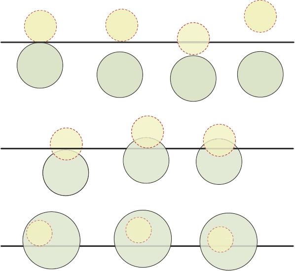
(these are shown in Figure 5.2); G represents the error range of GPS and R repre-
sents the error range of RFID; and (d) R, the error range of RFID, is smaller than G,
the error range of GPS.
Figure 5.2(a) shows the cases where the GPS error range and the RFID error
range do not overlap. Figure 5.2(b) shows the cases where the GPS error range and
the RFID error range overlap and R is not entirely within G. Figure 5.2(c) shows the
cases where R is entirely within G.
The two algorithms are designed to handle these cases above and be able to de-
tect three scenarios with respect to the movement of the user: (a) user’s movement
indicates a potential transition between the two environments; (b) the time when
transition between the two environments occurs; and (c) the location where the
transition between the two environments occurs.
Fig. 5.2 Different cases between G (GPS in outdoor) and R (RFID in indoor). a R and G do not
overlap (R ∩ G = ∅). b R and G overlap but R is not entirely within G (R ∩ G ≠ ∅ and R ⊄ G).
c R and G overlap but R is entirely within G (R ⊂ G)
a
c
Indoor
Entrance
Outdoor
G
G
G
G
G
G
G
G
G
R
R
R
Indoor
Entrance
Outdoor
G
G
G
G
R
R
R
R
b
G
Indoor
Entrance
Outdoor
G
G
R
R
R
5.4 Algorithms

96
5.4.1 Outdoor-Indoor Algorithm
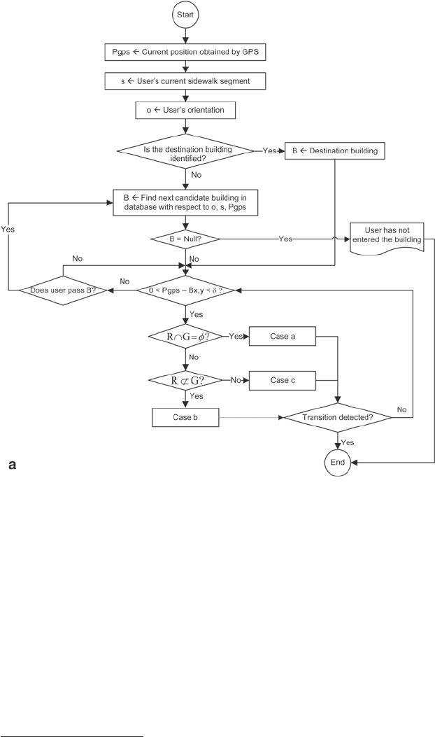
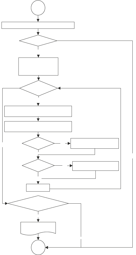
Figure 5.3 shows the algorithm for user’s movement from outdoor to indoor.
The algorithm assumes no destination given by the user, therefore, as the user
walks on the sidewalk, the algorithm searches the database for an upcoming
building on that sidewalk segment as candidate building. Any new GPS data
is map matched to estimate user’s location. If user’s location is not detected
within the range of G, then the algorithm assumes that the user is not entering
that building and continues the process of finding the next upcoming build-
ing as candidate building. However, if user’s location is detected within the
range of G, then the algorithm assumes that the user may be entering the build-
ing and receives additional position data to verify that he user is within the
range of G. The algorithm addresses two possible combinations of R and G
no overlap, the algorithm in Figure 5.3(b) addresses those non-overlap cases
shown in Figure 5.2(a) and overlap (R not entirely within G), the algorithm in
Figure 5.3(c) addresses those overlap cases shown in Figure 5.2(b).
5.4.2 Indoor-Outdoor Algorithm
Figure 5.4 shows the algorithm for user’s movement from indoor to outdoor. The
algorithm assumes no destination given by the user, which potentially could com-
plicate the process in buildings with multiple entrance/exit doors. Any new position
data by RFID is map matched to estimate user’s location. As the user walks on the
hallway of a building, the algorithm checks for RFID signals near the entrance/exit
door. If user’s location is not detected within the range of R, then the algorithm as-
sumes that the user is not exiting the building and continues the process of finding
user’s location within the building. If user’s location is detected within the range of
R then the algorithm assumes that the user may be exiting the building and receives
additional position data to verify that the user is within the range of R. The algo-
rithm addresses two possible combinations of R and G no overlap, the algorithm in
Figure 5.4(b) addresses those non-overlap cases shown in Figure 5.2(a) and over-
lap (R not entirely within G), the algorithm in Figure 5.4(c) addresses those cases
shown in Figure 5.2(b).
Figure 5.5
1
shows a route from an origin in indoor to a destination in outdoor.
The total route has two parts, one in indoor and one in outdoor. The indoor part of
the route uses the hallway network of the building and a set of user’s preferences to
compute a route from the origin to the entrance/exit door. The outdoor part of the
route uses the sidewalk network in the area connected to the building and a differ-
ent set of user’s preferences to compute a route from the entrance/exit door of the
building to the destination. Even when both sets of user’s preferences for routes in
1
http://nees.berkeley.edu/Facilities/images/building484a.jpg
5 Anywhere Navigation
97
indoor and in outdoor are the same (i.e., the user has the same routing preferences in
the building and in the outdoor), the computation still has to perform two steps: one
for finding a route in the indoor (origin and entrance/exit door pair) and another for
finding a route in the outdoor (entrance/exit door and destination pair).
Figure 5.6
2
shows a route from an origin in outdoor to a destination in indoor.
The total route has two parts, one in outdoor and one in indoor. The outdoor part of
the route uses the sidewalk network of the area connected to the building and a set
of user’s preferences to compute a route from the origin to the entrance/exit door of
the building. The indoor part of the route uses the hallway network of the building
2
http://rufrealty.com/Collegeblvd/bldglyout/images/CBPOffice2.gif
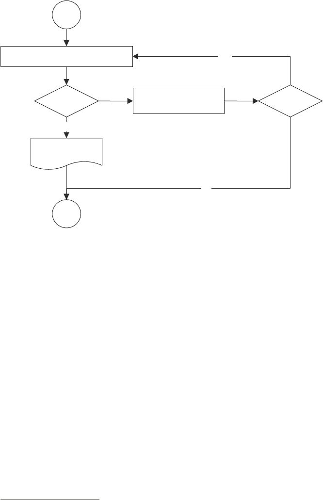
Fig. 5.3
Outdoor-indoor algorithm cases. a Outdoor-indoor algorithm. b Outdoor-indoor algo-
rithm (non-overlapping case). c Outdoor-indoor algorithm for overlap but R not entirely within
G case
5.4 Algorithms
98
and a different set of user’s preferences to compute a route from the entrance/exit
door of the building to the destination. Similar to the routing from indoor to outdoor
case, even when both sets of user’s preferences in outdoor and in indoor are the
same (i.e., user has the same routing preferences in the building and in the outdoor),
the computation still has to perform two steps: one for finding a route in the outdoor
(origin and entrance/exit door pair) and another for finding a route in the indoor
(entrance/exit door and destination pair).
Figure 5.7
3
shows a route from an origin in indoor, passing through outdoor, to a
destination in indoor. The total route has three parts, the first part in indoor, the second
part in outdoor, and the third part in indoor. The first part of the route in indoor uses the
hallway network of the building where the origin is located and a set of user’s prefer-
ences to compute a route from the origin to the entrance/exit door of the building. The
second part of the route in outdoor uses the sidewalk network in the area connected
to the building where the origin is located and a different set of user’s preferences to
compute a route from the entrance/exit door of the building to the entrance/exit door of
the building where the destination is located. The third part of the route in indoor uses
the hallway network of the building where the destination is located and a different set
of user’s preferences to compute a route from the entrance/exit door of the building to
3
http://bcs.solano.edu/building.JPG
5 Anywhere Navigation
Prfid = null?
User has entered
building
No
Yes
Prfid position obtained by RFID
Pgps position
obtained by GPS
Start
Pgps = null?
Yes
End
No
b
Fig. 5.3 Continued
99
Pgps current position obtained
from GPS
Prfid = null
NUMrfid - NUMgps > 0?
t < Specified time?
Prfid current position obtained
from RFID
Pgps = null
Prfid = null
Yes
Yes
NUMgps NUMgps + 1
NUMrfid NUMrfid + 1
No
No
t t +1
Yes
No
User has entered
building
t 0
NUMgps 0
NUMrfid 0
No
No
Prfid current position obtained by RFID
Start
Yes
End
Yes
c
Fig. 5.3 Continued
5.4 Algorithms
