Grillo O., Venora G. (eds.) Biodiversity Loss in a Changing Planet
Подождите немного. Документ загружается.


Assessing Loss of Biodiversity in Europe
Through Remote Sensing: The Necessity of New Methodologies
31
For example, for the Annex I habitat “Calcareous Beech Forest (code 9150)”, first a rule was
defined that selects the broadleaf forests from the CORINE land cover database, then a
second rule was used to select the beech distribution map from the Atlas Florae Europaeae,
and a third rule identified the calcareous soils from the European soil database. The
combination of these three filters will form the decision rule that delimitates the spatial
extension of calcareous beech forest.
The main advantage of this approach is the suggestion of using specific knowledge,
implemented as a GIS decision rule, to identify individual habitat maps as they are
described in Annex I of Habitats Directive. The approach use remote sensing data in an
indirect way (through the use of CORINE land cover and other input variables) along with
other suitable ancillary data. Results are appropriate at European scale in order to set
guidelines for the strategic design of the Pan-European Ecological Network.
5.2 Object oriented approaches (Bock et al. 2005; Díaz Varela et al. 2008)
Bock et al. (2005) have proposed an object-oriented approach for EUNIS habitat mapping
using remote sensing data at multiple scales with good results. The approach performs well
when applied to high resolution satellite data (Landsat 30m) for the production of habitat
maps at regional level with coarse thematic resolution; also it performs extremely well when
applied to very high spatial resolution data (Quickbird 0,7m) for the production of local
scale maps with fine thematic resolution.
The use of a multi-scale segmentation (implemented in the software package eCognition,
Definiens, http://www.definiens.com) allow for the accurate classification of habitat types,
which occur at different scales: for example, large-scale woodland habitat can be detected at
coarser segmentation levels, while small-scale habitats such as woodland corridors can be
detected at finer segmentation levels.
The main advantages of the object-oriented approaches to habitats mapping are: i) the
ability to integrate ancillary data into the classification processes, related to shape, texture,
context, etc.; ii) the option of developing knowledge-based rules in the classification process.
Both questions make especially possible the accurate identification of habitats with similar
spectral properties. Some results that show the advantage of these issues are (Bock et al.
2005): i) the effective separation of different grassland types like calcareous and mesotrophic
grassland habitats to a high degree of accuracy through the use of geological data; ii) the use
of multi-temporal remote sensing data to distinguish among arable lands, manage
grasslands and semi-natural habitats.
5.3 The use of binary classifications by decision trees (DT) (Boyd et al. 2006; Foody et
al. 2007; Franklin et al. 2002; Franklin et al. 2001)
Some studies have shown binary classifications as one of the more appropriate methods to
identify habitats in the territory. Binary classifications can be implemented by non-
parametric Decision Trees (DT) algorithms. Some of these studies have focused on the
mapping of one specific thematic class (Boyd et al. 2006; Foody et al. 2007) hypothesizing
that non-parametric algorithm would be more suitable to habitats of conservation interest
because of the scarce spatial distribution usually associated to them (the size of the training
sample will be smaller). Other studies have combined that kind of techniques (binary
classifications by DT) in hybrid approaches (Franklin et al. 2001). The hybrid approaches
assumes that parametric algorithms like standard maximum likelihood (ML) are the best

Biodiversity Loss in a Changing Planet
32
option with spectrally different habitats while applies non-parametric algorithms to other
complex habitats, in a so-called Integrated Decision Tree Approach (IDTA). The IDTA
(Franklin et al. 2001) consist on a process with a simple set of classification decision steps,
readily understood and repeatable. The approach allows mixing unsupervised, supervised
and stratification decision rules such that requirements for training data were minimized.
The general advantages of this kind of approaches are: i) those linked to the use of non-
parametric algorithms (Tso and Mather 2009), for example less restrictions with the size of
the training sample; ii) the use of key input variables combined with key algorithms defined
following specific characteristics of individual habitats; iii) The use of a type of geospatial
input data (nominal, ordinal, interval or ratio data like forest inventory maps, biophysical
and derived maps) that are difficult to incorporate into a statistical classifier.
5.4 New model based on the identification of ecological-units and on the selection of
habitat-key variables (Advances from Martinez et al., 2010)
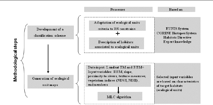
The methodology proposed in this model is summarized in Figure 2. The approach includes
two main steps: the adaptation of an international classification scheme and the generation
of ecological unit maps. The concept of ecological unit goes farther than land cover notion:
through ecological expert knowledge it is possible identify in the study area ecological units
directly related to Annex I habitats (Table5). Each ecological unit is linked to a distinctive set
of characteristic habitats through ecological expert knowledge. Consequently, the system
allows identifying and assessing the habitats listed in Annex I of Habitats Directive
92/43/EC through the identification of land covers by remote sensing.
Ecologically significant units of analysis were defined (Table 5), based on the EUNIS pan-
European classification proposed by the EEA and the CORINE Biotopes System of
Classification (www.eea.europa.eu, last accessed, May 2011). By using these systems, the
approach can be applicable to other European regions and it will produce cross-comparable
results.
The generation of ecological unit mapping is based on the selection of key input variables
(spectral, derived and ancillary variables) as a function of the main characteristics of the
target habitats and on the use of a standard maximum likelihood classification (MLC)
algorithm (Swain and Davis 1978). The target habitats are those defined in the Annex I of the
Habitats Directive for the Atlantic Biogeographical Region. Because of the not direct
correspondence between spectral classes and habitat types, we propose the combination of
ecological expert knowledge to find the relationship between both of them (step 1) along
with the selection of suitable input variables (step 2) in order to achieve the best possible
classification of habitats.
The study area was the Biosphere Reserve of Terras do Miño in the Northwest of Iberian
Peninsula (Figure 3).The classification process was undertaken by the use of multi-temporal
Landsat ETM+ images and ancillary data.
Input variables were rectified to the Universal Transverse Mercator Projection (UTM 29T)
using the European Datum 1950 (ED50) and resampled to 30m grid size. Training samples
were taken by fieldwork. They were located with a global positioning system (GPS)
differential receiver. Training sites were selected as to be large and representative enough to
characterize each target class and provide efficient and unbiased estimators using stratified
sampling. At least 50 additional points per ecological unit were surveyed on the field for
results assessment. These data were not used in the training process.
Assessing Loss of Biodiversity in Europe
Through Remote Sensing: The Necessity of New Methodologies
33
Fig. 2. Flowchart of the methodological steps for the model applied to Biosphere Reserve
Terras do Miño
Early spring (March 26, 2002), late spring (May 26, 2001) and summer (August 17, 2002)
images were selected for this model to account for the seasonal trends in vegetation
communities. Images were geometrically registered using ground control points (GCP), first
order transformations and nearest neighbor interpolation. The August 2002 image was geo-
referenced to 1/25,000 digital maps, produced by the National Geographical Institute of
Spain and used as a reference for geometrical correction of the other images. Atmospheric
correction was based on the dark-object technique proposed by Chavez(Chavez 1996).
Correction for effects of ground slope and topographic orientation was computed using the
Lambertian cosine method initially proposed by Teillet et al. (Teillet et al. 1982) and later
modified by Civco (Civco 1989). To model illumination conditions a Digital Elevation Model
(DEM) was generated using contour lines from 1/5000 digital cartography. The thermal
band was not included in the classification processes.
It was hypothesized that derived and ancillary variables would provide critical information
for landscape classification and enable the identification of complex habitats. For example,
topographic features and vicinity to fluvial corridors have an important influence on the
distribution of natural and semi-natural habitats; therefore, the discrimination of this type of
habitats should be favored by those variables.
The input dataset for classification processes included satellite derived variables
(reflectance, vegetation indices, texture measures and spectral mixture analysis) along with
continuous ancillary data. Reflectance bands were included using principal components
transform (Mather 2004) in order to reduce the dimensionality of the dataset and optimize
the number of training samples. Vegetation indices were: NDVI (Normalized Difference
Vegetation Index) (Rouse et al. 1974) and NDII (Normalized Difference Infrared Index;
using Landsat TM Band 5) (Hunt and Rock 1989). Texture measures (homogeneity using
Band 3 of each Landsat ETM+ image) were calculated using the co-ocurrence matrix as
designed by Haralick et al. (Haralick et al. 1973). The co-ocurrence matrix was computed
from a window of 3x3 pixels, which was considered an optimum size for measuring
neighbor conditions. Linear spectral mixture analysis (SMA) (Mather 2004) generated

Biodiversity Loss in a Changing Planet
34
endmember spectra, which are defined as the proportion of each pixel covered by a basic
spectral class. The included endmembers were water, soil, green vegetation (GV), and
ECOLOGICAL UNIT
NATURA 2000 Code
(Main Habitat)
Natural –Seminatural Landscape
Standing Water
3110/3120/3130
3140/3150/3160
3260/3270
Running Water
W
Water courses
Inland no-wooded wetlands
WH
Bogs (Raised and blanket bogs) and Atlantic wet heaths
7130/7110*/7120
7230, 4020*
HM Tall and mid-herb humid meadows 6430,6410
Inland wooded wetlands
RF Alluvial and riparian forests 91D0*/91E0*/91F0
Other natural and seminatural forests
DF
Deciduous oak forests 9230
Rocky habitats and other heaths
DH
Siliceous rocky habitats and dry heaths 4030/8220
Anthropic Landscape
Forest plantations
P
Pine sp. groves
E
Eucalyptus sp. plantations
Transformed rural landscape
TF
Rural system mainly made up of pastures
TR
Rural system mainly made up of corn and pasture in rotations
BL
Bare land
Traditional rural landscape
CG
Traditional rural mosaic with fenced fields, dominated by crops
and grasslands
6410/6510
WG
Traditional rural mosaic with fenced fields, dominated by wet
grasslands
6410/6510
Man-made landscape
Ur
Urban areas (villages, towns)
ME
Mining exploitations
I
Communication infrastructures
B
Buildings for agricultural, forestry and industrial use
Table 5. Ecological units directly related to CD 92/43/EEC habitats in the proposed model
Assessing Loss of Biodiversity in Europe
Through Remote Sensing: The Necessity of New Methodologies
35
non_photosynthetic vegetation (NPV). SMA models the reflectance of each pixel as a linear
combination of reflectance of those four components. It was assumed constrains of no
negative values and that the four components explained the whole variation of reflectance,
although the model was allowed to produce a residual image.
Slope gradient was calculated from the DEM. Proximity to rivers was calculated from the
1/5000 river map using raster processing.
Results were assessed by cross-tabulation with a sample of pixels included in test plots.
Global, user and producer accuracies were evaluated using an error matrix (Congalton and
Green 2009). Additionally the Kappa analysis (Congalton and Green 2009) was used to
evaluate the accuracy of the results: we used KHAT statistic to measure how well the
remotely sensed classification agrees with the reference data, the Z statistic to determine the
significance of a matrix error and the Z pairwise comparison to decide if two KHAT values
are significantly different.
CODE VARIABLES
GA
(%)
KHAT
MLC
1
PCs (may+march+august) 75,56 0,733
*MLC
2
PCs (may+march+august) + NDVI (my,ag) + NDII
5
(my,ag) + prox.
streams + SLOPE+ Homogeneity- B
3
(my, mz, ag)+ WATER
(endmember-mz)+ FMo 3x3
82,75 0,811
Legend: [GA] Gloabl accuracy (%). [MLC]: Maximun likelihood classification, [*] without Bare Land
class, [PCs]: Principal Components,
[FMo]: modal filter
Table 6. Global accuracies for parametric multi-temporal processes (MLC algorithm)
CODE GA (%) KHAT Z PAIR-WISE Z SCORES**
MLC
1
75,56 0,733 50,126*
MLC
2
82.75 0,811 62,089* 3,496569*
Legend: [MLC]: Maximun likelihood classification [*] Significant at the 95% confidence level. [**]
Comparison with MLC
1
Table 7. Kappa analysis for parametric multi-temporal processes (MLC algorithm)
The results of this model showed 82.75% global accuracy after the application of a modal
filter. The best result provided a Kappa value (Congalton and Green 2009) of 0.811 with a Z
value indicating very good agreement between classification results and the reference data.
Tables 6 and 7 shows the accuracy assessment for two processes: i) one of them based on the
principal components of the three images (MLC
1
); ii) the second one also includes the group
of ancillary and derived variables (MLC
2
). Some variables like slope, distance to rivers,
NDVI, NDII and homogeneity showed its valuable potential (Table 9). The combination of
all of them in the best MLC trial produced a significant increase in global accuracy along
with an increase on user and producer accuracies for the most part of the classes of habitats
(Table 8). MLC
2
showed user and producer accuracies above 70% and 80% in the most part
of habitats. Only WH and forests showed producer or user accuracies less than 60%.

Biodiversity Loss in a Changing Planet
36
ECOLOGICAL
UNITS
MLC
1
MLC
2
user producer
user producer
WG
60,41 87,00
74,22 95,00
TR
97,19 100,00
96,30 100,00
CG
84,62 74,00
85,85 87,50
HM
43,94 72,5
73,81 77,50
DF
59,74 44,23
76,39 52,88
RF
52,88 55,0
59,84 73,00
WH
53,33 26,67
73,91 56,67
P
97,92 90,38
96,23 98,08
E
94,74 90,0
90,91 100,00
TF
84,26 91,0
91,01 81,00
TI
100,00 91,67
100,00 91,67
W
100,00 100,00
100,00 100,00
ME
100,00 100,00
100,00 83,33
Ur+I+B
83,33 100,00
86,96 100,00
BL
66,67 30,0
---- ----
DH
82,28 81,25
83,56 76,25
Legend: [MLC]: Maximun likelihood classification
Table 8. User and producer accuracies for parametric multi-temporal processes (MLC algorithm)
Kappa analysis
Variables
Global
accuracy
Improvement in
multi-temporal***
KHAT Z
Pair-wise
Z
scores***
DEM + Slope
76,05 0,49
0,738 50,792* 0,256709
Prox. to streams
76,34 0,78
0,742 51,213* 0,412576
NDVI and NDII**
77,91 2,35
0,758 53,603* 1,248175
Homogeneity**
77,22 1,66
0,751 52,467* 0,867394
Endmember Water
75,75 0,19
0,735 50,442* 0,102807
Legend: [*] Significant at the 95% confidence level. [**] Three images. [***] In relation to the trial with
principal components of the three images
Table 9. Improvement in global accuracy for multi-temporal analyses after adding to the
classification the layers showed in the table.
The contribution of topographical variables and vegetation indices to the habitat mapping
accuracy is appropriate for the analyses; the combination of vegetation indices was relevant
in the analyses, with improvements in global accuracy (to a maximum of 2.35% of accuracy
increase when both NDVI and NDII were combined in the process) (Table 9). The
topographical variables (Slope and MDE) improved also the global accuracy of multi-
temporal classifications, although to a lesser extent than variables like homogeneity. Texture
measures and SMA components did not provide significant improvements in global
accuracy in parametric methods. However they showed to be suitable for improving the
discrimination of some particular classes like HM, WH or Ur. Therefore, they could be
considered as interesting and helpful variables for nonparametric methods in order to get
good discrimination of some classes.

Assessing Loss of Biodiversity in Europe
Through Remote Sensing: The Necessity of New Methodologies
37
The special interest of this approach comes from the use of an international classification
system (EUNIS) that will allow cross-comparable spatial and temporal assessments and
make the methodology extrapolated to other regions. The definition of ecological units goes
farther than the simple land cover idea and it allows the definition of a direct relation win
AnnexI habitats and consequently with species. Finally the use of a standard maximum
likelihood algorithm based on the selection of key input variables makes possible the
accurate identification of many ecological units.
Fig. 3. Localization of the Biosphere Reserve Terras do Miño and de SCI Parga-Ladra-Támoga
in Galicia (NW Spain)
The output classification of this model and the CLC map (5
th
level) were spatially compared
with a habitat map of the Site of Community Importance (SCI) Parga-Ladra-Támoga in the
Northwest of Iberian Peninsula (which belongs the Biosphere Reserve of Terras do Miño).
This map was elaborated by photo interpretation through aerial photography with different
scales ranging from 1/20000 until 1/2000 (Ramil et al. 2005). It also based on expertise
fieldwork and its minimum mapping unit was 0,5ha. The map was the reference to evaluate
this site as a candidate to belong to Natura 2000 ecological network.
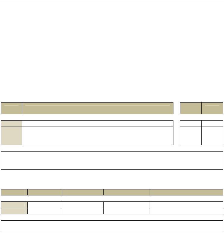
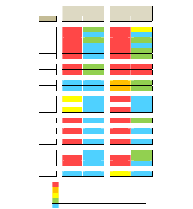
Again, spatial inconsistencies between both sources (CLC and the model applied to Biosfere
Reserve Terras do Miño) were evaluated using this map by the analysis of coincidences in the
cells of two different grids (UTM based): 1 and 10 km
2
.
Biodiversity Loss in a Changing Planet
38
10 KM GRID
(UTM)
1 KM GRID
(UTM)
HAB CLC MODEL CLC MODEL
3110
0,00 77,78 0,00 35,14
3120
0,00 100,00 0,00 100,00
3130
0,00 83,33 0,00 70,00
3140
0,00 100,00 0,00 100,00
3150
0,00 100,00 0,00 80,00
3160
0,00 100,00 0,00 50,00
3260
6,67 73,33 1,40 5,83
3270
6,67 66,67 2,41 9,64
4020*
90,91 100,00 18,63 88,24
4030
91,67 100,00 26,16 78,48
6410
38,46 100,00 1,78 100,00
6430
-
100,00 - 91,29
6510
46,15 100,00 2,08 100,00
7110*
0,00 100,00 0,00 89,47
7230
0,00 100,00 0,00 100,00
8220
0,00 100,00 0,00 100,00
91D0*
-
100,00 - 88,89
91E0*
0,00 100,00 0,00 78,88
91F0
0,00 100,00 0,00 96,97
9230
100,00 100,00 30,77 99,04
Total gap: less than 10% of coincidences
Very high gap: coincidences between 10-30 %
High gap: coincidences between 30-50%
Moderate gap: coincidences between 50-90%
No gap: coincidences upper 90%
Table 10. Spatial correlations between CD 92/43/EEC habitats cartography, Corine Land
Cover cartography (5
th
level) and the MODEL Terras do Miño in the SCI Parga-Ladra-
Tamoga (NW Spain)
At 10km CLC shows a total gap in the most part of the habitats (Table 10). Only heaths and
the woodlands with Quercus spp. (9230) have good correspondence. At 1 km CLC shows
total or very high gap in any case. On the other hand, the model of Terras do Miño shows
good results at 10km. At 1km, the most part of the habitats present good correspondence or
moderate gap. Only two habitats present total gap which corresponds to water courses
(3260 and 3270) which can be assigned to the constraints of the spatial resolution of the
images.

Assessing Loss of Biodiversity in Europe
Through Remote Sensing: The Necessity of New Methodologies
39
Results show that, although both sources (CORINE and the model) are based on LANDSAT
images with 30m of spatial resolution, the inclusion of decisive variables in the classification
processes along with the identification of ecological units was crucial. And it is again proved
that it is uncertain to use CLC as a proxy of habitat maps.
6. Conclusions
To meet the requirements of European policies such as Natura 2000 Network and the 2020
EU Biodiversity Strategy the development of more cost and time effective monitoring
strategies are mandatory. Remote sensing (RS) techniques contribute significantly to
biodiversity monitoring and several approaches have been proposed to get on-going
requirement for spatially explicit data on the ecological units, and the value and threats
against natural and semi-natural habitats (Bock et al. 2005; Weiers et al. 2004), but no
definite nor any that has been standardized across Europe.
The major obstacles to get standardized scientific monitoring methodologies for habitat
monitoring form a complex patchwork. The immense versatility of RS, the full range of RS
techniques and products, has led to numerous potential approaches but all of them are
dependent of many factors: i) firstly the large variability in the quality of input variables,
their semantic, thematic and geometrical accuracy; many approaches have assumed the
suitability and representativity of the selected geospatial data; ii) secondly, the possible
variability of the spectral, spatial and temporal resolutions; iii) finally, the availability of
suitable RS and ancillary data.
There is no a simple relationship between habitats and biophysical parameters like land
covers (Groom et al. 2006). Habitat classes are not the same that land cover classes and the
inconsistencies and gaps when a land cover map, as CORINE Land Cover, is used as a
surrogate of a habitat map are significant and it should be evaluated in each case. It is
necessary to develop ad hoc criteria to get the objective of identifying and monitoring
habitats from remote sensing. It should be found the optimal way (cost effective and in an
acceptable time, and with an optimal level of accuracy) to get from one unit of land cover
(which can definitely be detected directly by remote sensing) to a unit of habitat (which may
be, at least not in a direct way).
At the European Community level the appropriate criteria for getting that relation should be
achieved through EUNIS system (Martínez et al. 2010; Moss and Davies 2002) since it is a
common denominator that is compatible with the requirements of Annex I of the Habitat
Directive. It will support the standardization because it makes possible cross-comparable
data: at spatial and temporal levels.
In regard to habitat identification through RS recent researches have suggested different
relevant considerations and requirements: study areas specific approaches; ecological expert
knowledge implemented as decision rules; the implementation/inclusion of key input
variables selected following specific characteristics of individual habitats; the integration of
ancillary data into the classification processes, related to shape, texture, context; the use of
non-parametric algorithms implemented through binary classifications or decision trees that
allow to include nominal, derived and ancillary geospatial data and also are advantageous
with scarce training samples; (Bock et al. 2005; Boyd et al. 2006; Foody et al. 2007; Franklin et
al. 2001; Kerr and Ostrovsky 2003; Martínez et al. 2010; Mücher et al. 2009).
On the other hand, insufficient integration at different scales is one of the constraints of the
current biodiversity monitoring programmes (Pereira and Cooper 2006) and it is also urgent

Biodiversity Loss in a Changing Planet
40
to advance in this issue. Remote sensing analyses of ecological phenomena at global scale
are too general to meet regional and local monitoring requirements. Medium and high
spatial resolution remotely sensed data, like Landsat TM and ETM+ sensors, have been
widely used in ecological investigations and applications, because their suitability at
regional and landscape scales. But there is a mismatch between broad-scale remote sensing
and local scale field ecological data (Kerr and Ostrovsky 2003): the synoptic view of the
remote sensing should be enhanced with in situ data and regional assessments should
combine high spatial resolution satellite RS with on-the ground monitoring, and aerial
photography or very high spatial resolution satellite RS in studying some habitats which are
best monitoring at small scales (Hansen et al. 2004; Pereira and Cooper 2006).
To conclude, the upcoming standardized methodology should incorporate these
recommendations. For habitat mapping through RS, expert knowledge and field
measurements should be combined with key input variables and optimal algorithms related
to each individual target habitat, implemented in a decision structure like a tree. At
European level the new methodology should be based on the EUNIS system that meets the
objectives and requirements of the Habitat Directive, the Convention of Biological Diversity
and the new 2020 biodiversity targets. It should also look at the new possibilities of medium
and high resolution satellite images.
7. Appendix 1
CLC 311 - Forest and semi natural areas / Forests / Broad-leaved forest
HC 9120 - Atlantic acidophilous beech forests with Ilex and sometimes also Taxus in the
shrublayer (Quercion robori-petraeae or Ilici-Fagenion)
EUNIS CORRELATION: G1.62, G1.6
HC 9180* - Tilio-Acerion forests of slopes, screes and ravines
EUNIS CORRELATION: G1.A, G1.A4
HC 91E0* - Alluvial forests with Alnus glutinosa and Fraxinus excelsior (Alno-Padion, Alnion
incanae, Salicion albae)
EUNIS CORRELATION: G1.1, G1.2
HC 91F0 - Riparian mixed forests of Quercus robur, Ulmus laevis and Ulmus minor, Fraxinus
excelsior or Fraxinus angustifolia, along the great rivers (Ulmenion minoris)
EUNIS CORRELATION: G1.2, G1.22, G1.223
HC 9230 - Galicio-Portuguese oak woods with Quercus robur and Quercus pyrenaica
EUNIS CORRELATION: G1.7, G1.7B
HC 9330 - Quercus suber forests
EUNIS CORRELATION: G2.1, G2.11
HC 9340 - Quercus ilex and Quercus rotundifolia forests
EUNIS CORRELATION: G2.1, G2.12
HC 9380 - Forests of Ilex aquifolium
EUNIS CORRELATION: G2.6
CLC 312 - Forest and semi natural areas / Forests / Coniferous forest
HC 9410 - Acidophilous Picea forests of the montane to alpine levels (Vaccinio-Piceetea)