Catuneanu O. Principles of Sequence Stratigraphy
Подождите немного. Документ загружается.

In a vertical profile that preserves the entire succes-
sion of facies, the wave-ravinement surface separates
coastal strata below (backstepping foreshore and back-
shore facies in an open shoreline setting, or estuarine
facies in a river-mouth setting) from shoreface and
shelf deposits above (Figs. 4.6, 4.48, and 4.49). Where
the transgressive coastal and fluvial deposits are not
preserved, the wave-ravinement surface may rework
the underlying lowstand normal regressive strata and
even the subaerial unconformity (Embry, 1995; Fig. 4.49).
In the latter case, the wave-ravinement surface becomes
part of the sequence boundary. The chances for a wave-
ravinement surface to replace the underlying subaerial
unconformity depend on the balance between the thick-
ness of the lowstand normal regressive strata and the
amount of subsequent wave-ravinement erosion, and
are highest in the case of short stages of lowstand
normal regression and/or low rates of aggradation
during the lowstand normal regression. Where stages
of lowstand normal regression result in the deposition
of thick (> 20 m) fluvial to coastal deposits, the subaer-
ial unconformity is preserved as such in the rock
record (Fig. 4.34).
In stratigraphic sections located immediately land-
ward from the shoreline position at the onset of
transgression, it is common for the wave-ravinement
surface to rework the maximum regressive surface and
the underlying lowstand beach, coastal plain or delta
plain strata, and therefore to be found within a fully
shallow-marine succession (Fig. 4.49). In such cases,
the distinction between a wave-ravinement surface
and the marine portion of a maximum regressive
surface (scoured and conformable contacts, respec-
tively, both separating coarsening-upward strata
below from fining-upward strata above; Figs. 4.9, 4.32,
and 4.49), solely from the study of well logs, may be
difficult (compare the well logs in Figs. 4.32 and 4.49).
Under these circumstances, additional information
(e.g., core material) is required for the unequivocal
identification of the wave-ravinement surface, in order
to document the scoured nature of this stratigraphic
contact (Fig. 2.26). Owing to their mode of formation,
wave ravinement surfaces are commonly marked by
the concentration of transgressive lag deposits, which
can be best observed in outcrop or core (Fig. 4.50).
Where developed within fully marine successions,
wave-ravinement surfaces are commonly demarcated
by firmgrounds (Glossifungites ichnofacies; MacEachern
et al., 1992) or hardgrounds (Trypanites ichnofacies;
e.g., case study by Krawinkel and Seyfried, 1996,
150 4. STRATIGRAPHIC SURFACES
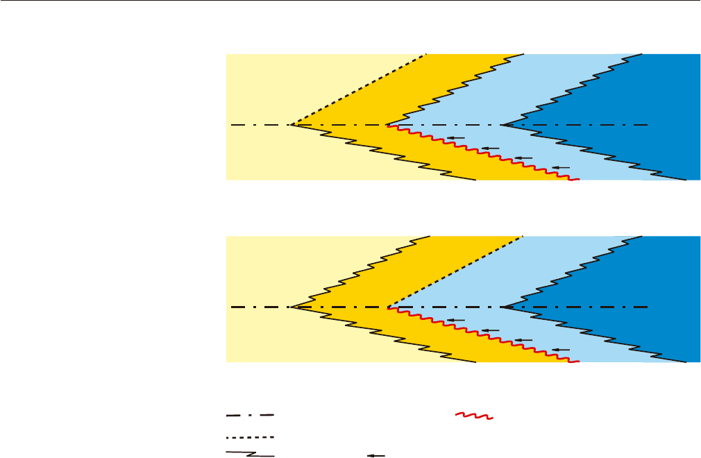
MFS
facies changes coastal onlap
Where a transgressive beach is preserved, the wave ravinement surface
does not merge with the within-trend normal regressive surface.
Beach
Beach
MFS
Where the estuary facies are preserved, the wave ravinement surface
merges with the within-trend normal regressive surface.
Estuary
Shoreface
Delta plain
Delta front
(shoreface)
Fluvial
Fluvial
Fluvial
Fluvial
Shoreface
Shelf
Shelf
1. Open shoreline setting
2. River mouth setting
ravinement surfacemaximum flooding surface (MFS)
within-trend normal regressive surface (facies contact)
FIGURE 4.48 Architecture of facies and
stratigraphic surfaces at the point of maxi-
mum shoreline transgression (from
Catuneanu, 2002). The position of the
within-trend normal regressive surface
varies with the type of coastline, between
open shoreline and river-mouth settings.
The wave-ravinement surface always sits
at the base of transgressive shoreface
facies. The maximum flooding surface
separates retrograding from overlying
prograding geometries. Within the trans-
gressive systems tract, the facies contact
between shoreface sands and the overly-
ing shelf shales defines the within-trend
flooding surface.
where the wave-ravinement surface is a wave-cut plat-
form with Gastrochaenolites borings and a thin veneer
of transgressive lag, cut into regressive shoreface
deposits and overlain by transgressive shoreface
facies). In stratigraphic sections located farther inland
relative to the shoreline position at the onset of trans-
gression, the chances of preservation of nonmarine
deposits beneath a wave-ravinement surface are higher,
and as a result such transgressive scours are commonly
cut into rooted nonmarine facies capped by firmgrounds
(Glossifungites ichnofacies) or woodgrounds (Teredolites
ichnofacies) (MacEachern et al., 1992; Pemberton et al.,
2001). The presence of coal beds within the nonmarine
succession that is subject to transgressive wave scouring
may limit the amount of downcutting, due to the more
resilient nature of coal, and as a result many wave-
ravinement surfaces are found directly on top of xylic
substrates (Fig. 4.51).
The term ‘wave-ravinement surface’ was intro-
duced by Swift (1975); synonymous terms include the
transgressive surface of erosion (Posamentier and Vail,
1988), shoreface ravinement (Embry, 1995) and transgres-
sive ravinement surface (Galloway, 2001). Figure 4.51
provides a field example of a ravinement surface that
separates coal-bearing fluvial floodplain strata from
the overlying transgressive shoreface facies. In this
example, no coastal deposits are preserved following the
wave-ravinement erosion, and the fluvial deposits are
transgressive (fluvial transgressive facies in Fig. 4.6).
As a result, this particular wave-ravinement surface
develops within a transgressive systems tract, and it is
not part of a systems tract or sequence boundary.
Tidal-Ravinement Surface
The tidal-ravinement surface is a scour cut by tidal
currents in coastal environments during shoreline
SEQUENCE STRATIGRAPHIC SURFACES 151
GR
Shallow marine
Coastal
Estuary
Fluvial
(delta plain)
15
0
(m)
Delta front
(shoreface)
conformable facies
contact
transgressive
shoreface
transgressive
shoreface
regressive
shoreface
regressive
shoreface
GR
25
0
(m)
LST
TST
HST
shelf
shelf
fluvial LST
fluvial HST
FSST
fluvial TST
estuary
subaerial unconformity
correlative conformity
basal surface of forced regression
regressive surface of marine erosion
ravinement surface
maximum regressive surface
maximum flooding surface
within-trend normal regressive surface
lateral shifts of facies
coastal onlap (healing phase deposits)
TST
HST
HST
TST
HST
LST
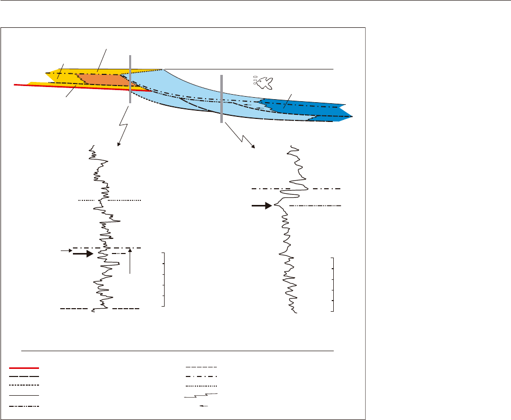
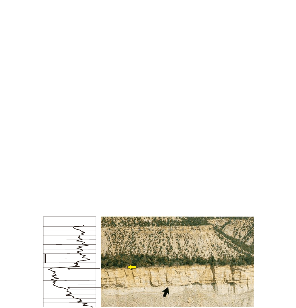
FIGURE 4.49 Well-log expression
of the transgressive wave-ravine-
ment surface (arrows; modified from
Catuneanu, 2003). See Fig. 4.9 for
a summary of diagnostic features of
the transgressive wave-ravinement
surface. Note that in fully shallow-
marine successions, the transgressive
wave-ravinement surface may
replace the maximum regressive
surface, if the log is located landward
relative to the shoreline position at the
onset of transgression. Log examples
from the Bearpaw Formation (left)
and Embry and Catuneanu (2001)
(right). Abbreviations: GR—gamma
ray; LST—lowstand systems tract;
TST—transgressive systems tract;
FSST—falling-stage systems tract;
HST—highstand systems tract.
transgression. Depending on the nature of coastal
deposits that are subject to scouring, as well as the
magnitude of tidal erosion, tidal-ravinement surfaces
may be demarcated by firmgrounds (Fig. 2.25), hard-
grounds (Fig. 2.27) or woodgrounds (Fig. 2.28). The
formation of such scour surfaces may be observed along
present-day transgressive coastlines (Figs. 2.25B, 2.27B,
and 2.28), or in the rock record where the fill of tidal
channels is preserved from subsequent transgressive
wave-ravinement erosion (Figs. 2.25A and 2.27A). The
process of tidal reworking of the underlying transgres-
sive or normal regressive (lowstand or even highstand)
deposits is equally important in open shoreline and
river-mouth settings, although the type of coastline is
a critical factor that controls the preservation of the
tidal-ravinement surface as a distinct stratigraphic
contact in the stratigraphic record. In open shoreline
settings, tidal reworking in the intertidal to coastal plain
areas is followed by wave erosion in the upper
shoreface, as the shoreline shifts in a landward direction
during transgression. For this reason, the tidal-ravine-
ment surface is generally replaced, shortly after forma-
tion, by the landward-expanding wave-ravinement
surface. This is why the wave-ravinement surface is
commonly the only type of transgressive ravinement
scour that is referred to in the majority of studies.
The chances of preservation of the tidal-ravinement
surface as a distinct stratigraphic contact are enhanced
152 4. STRATIGRAPHIC SURFACES
TL
TL
FR
FR
A
B
C
C
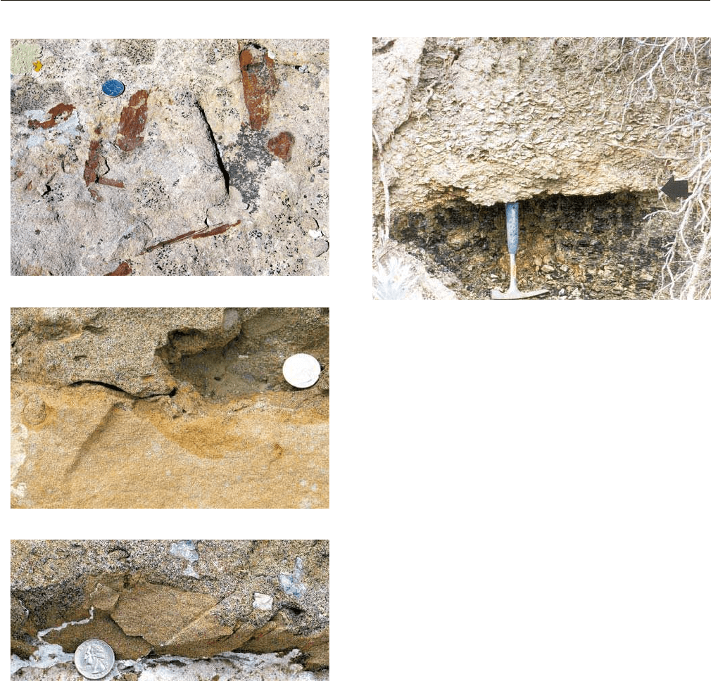
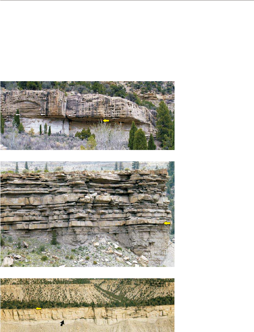
FIGURE 4.50 Outcrop examples of transgressive lag deposits
associated with wave-ravinement surfaces. A––plan view of a wave-
ravinement surface, showing the presence of transgressive lag
deposits (plant debris in this case). In this example, the wave-ravine-
ment surface is at the top of coarsening-upward shoreface deposits
(a ‘parasequence’), and it is overlain by transgressive shales (not
shown). This type of sharp lithological contact, from sands below to
shales above, qualifies the wave-ravinement surface as a ‘flooding
surface’ (Late Cretaceous Blackhawk Formation, Utah); B, C––wave-
ravinement surface associated with transgressive lag deposits
(‘TL’––coarse sandstone with shell fragments). In this example, the
wave-ravinement surface is at the top of forced regressive delta front
deposits (‘FR’), is overlain by transgressive marine shales (not
shown), and reworks the subaerial unconformity. This wave-ravine-
ment surface also fits the definition of a ‘flooding surface,’ and, in
this case, is part of the sequence boundary (Campanian Panther
Tongue Formation, Gentle Wash Canyon, Utah).
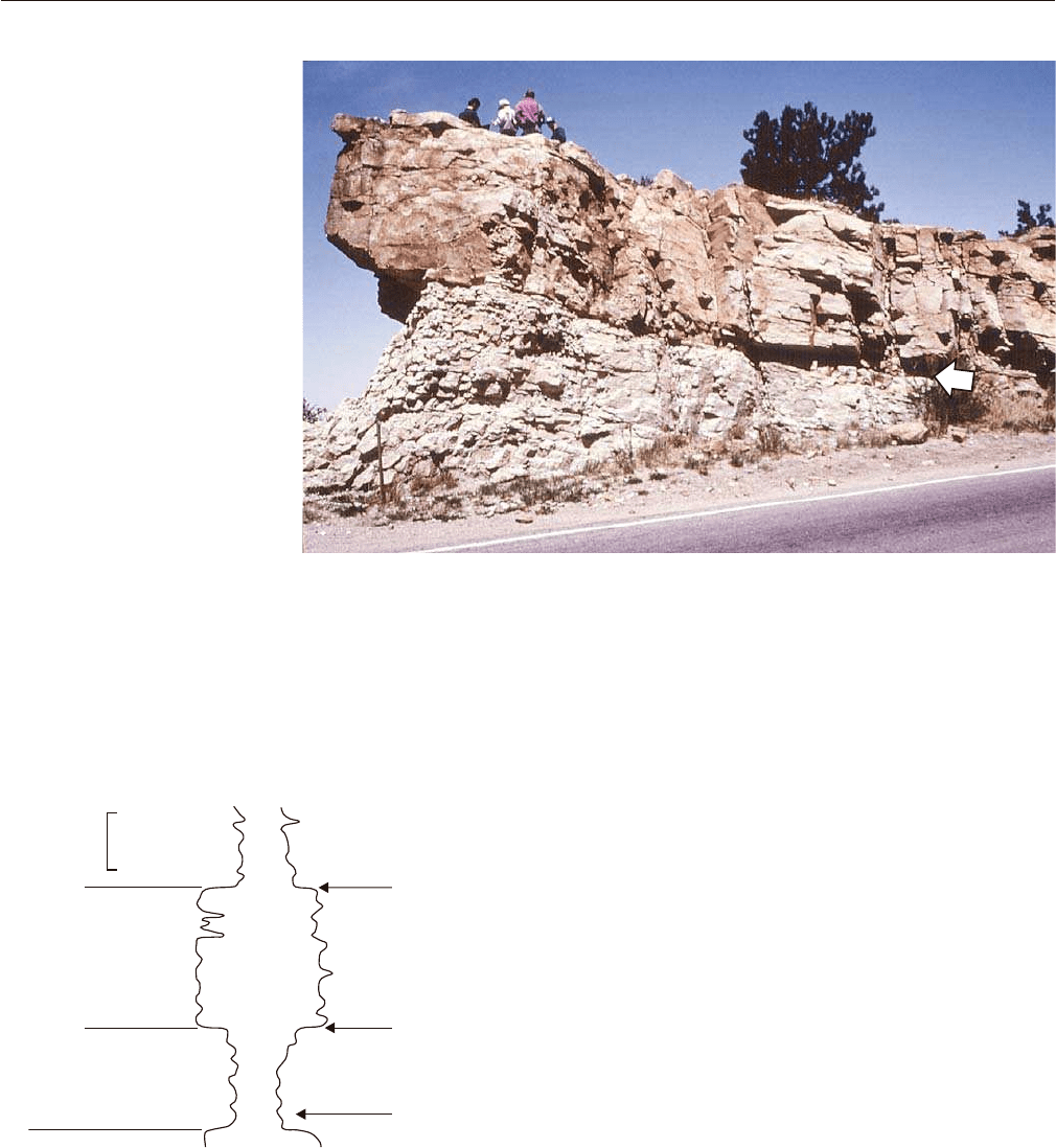
FIGURE 4.51 Wave-ravinement surface separating transgressive
shoreface facies with Oyster coquina from the underlying coal-bear-
ing fluvial facies. The latter are interpreted as transgressive
(Hamblin, 1997), hence this portion of the ravinement surface devel-
ops within a transgressive systems tract and it is not a systems tract
or sequence boundary. Contact between the Dinosaur Park
Formation (Belly River Group) and the Bearpaw Formation, south-
ern Alberta, Western Canada Sedimentary Basin.
in transgressive river-mouth settings, where the rates of
aggradation of the estuary-mouth complex outpace the
rates of subsequent wave-ravinement erosion (Figs. 4.46
and 4.47). In such settings, the two transgressive ravine-
ment surfaces are separated by the sandy deposits of
the estuary-mouth complex (Fig. 4.52). In a most
complete scenario, where most estuarine facies are
preserved, the tidal-ravinement surface occurs at the
contact between central estuary muds below and estu-
ary-mouth sands above (Allen and Posamentier, 1993;
Fig. 4.52). The preservation of the underlying central
estuary muds depends on the balance between the
rates of aggradation in the central estuary and the
rates of subsequent tidal erosion, as all subenviron-
ments shift in a landward direction. In turn, these two
opposing forces, of sedimentation vs. erosion, are a
function of several variables, including sediment
supply, available accommodation, and tidal range.
Higher sediment supply contributes towards
increased rates of aggradation, whereas a higher tidal
range increases the magnitude of tidal scouring, coun-
teracting the effect of sedimentation.
The documentation of tidal-ravinement surfaces is
most common in case studies involving incised-valley
fills, as the bulk of such deposits is generally tidally
influenced and estuarine in origin. The Gironde estu-
ary in France provides a classic example of a mixed
tide- and wave-influenced coastal setting, where the
fill of the incised valley preserves a full succession of
lowstand fluvial, transgressive estuarine, and high-
stand deltaic sedimentary facies (Fig. 4.52; for core
photographs, see Fig. 6 of Allen and Posamentier,
1993). This case study provides a good example of a
tidal-ravinement surface at the contact between
central estuary and overlying estuary-mouth facies
(Allen and Posamentier, 1993). In coastal settings char-
acterized by rapid transgression following the onset of
base-level rise, high tidal range, and/or reduced
accommodation, the lowstand fluvial deposits, as well
as the low energy central estuarine facies may not be
preserved in the rock record. In such cases the tidal-
ravinement surface reworks the subaerial unconfor-
mity, and the underlying highstand facies may range
from fluvial to shallow-marine (Figs. 4.9, 4.53, and
4.54). Irrespective of the nature of underlying facies,
the preservation of a tidal-ravinement surface as such
requires the presence of estuary-mouth complex
deposits on top (Fig. 4.9). As with the wave-ravine-
ment surface, the tidal-ravinement surface is highly
diachronous, with a rate that matches the rate of shore-
line transgression.
WITHIN-TREND FACIES CONTACTS
In addition to the seven sequence stratigraphic
surfaces described above, facies contacts associated
with a strong physical expression may also be recog-
nized within the various systems tracts. Such litholog-
ical discontinuities may be caused by shifts in
depositional environments accompanied by corre-
sponding changes in environmental energy and sedi-
ment supply during transgressions or regressions, and
are surfaces of lithostratigraphy or allostratigraphy.
They are not proper sequence stratigraphic surfaces as
they do not serve as systems tract boundaries. In a
sequence stratigraphic approach, within-trend facies
contacts need to be dealt with only after the frame-
work of sequence stratigraphic surfaces has been
constructed. A discussion of the most prominent types
of within-trend facies contacts follows below.
Within-trend Normal Regressive Surface
The within-trend normal regressive surface is a
conformable facies contact that develops during
normal regressions at the top of prominent shoreline
WITHIN-TREND FACIES CONTACTS 153
Tidal estuarine sand and mud
(TST)
Estuary mouth complex (TST)
Prograding HST
025(km)
Coarse fluvial deposits (LST)
subaerial unconformity
maximum regressive surface
maximum flooding surface
wave ravinement surface
tidal ravinement surface
Landward
Transgressive lag
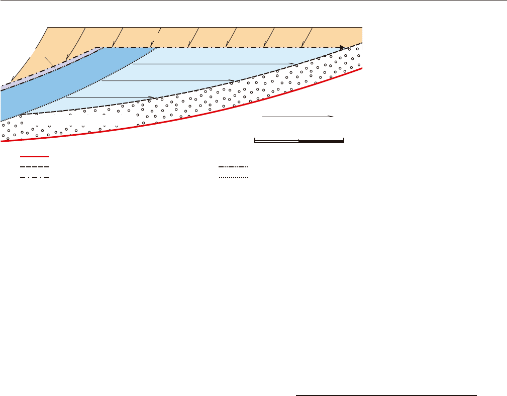
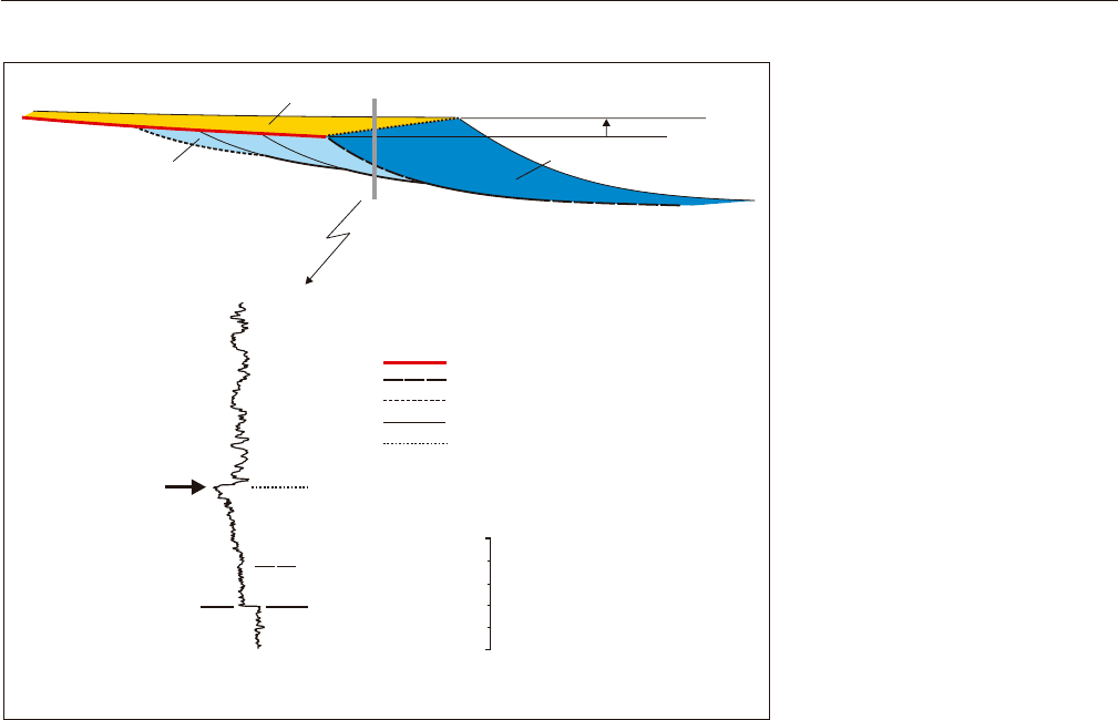
FIGURE 4.52 Stratigraphic model
of an incised-valley fill, based on the
Gironde estuary (modified from
Allen and Posamentier, 1993). Note
the spatial relationship between
sequence stratigraphic surfaces, as
well as their relation with the various
facies of the incised-valley fill. This
case study provides a most complete
scenario, where all systems tracts
that form during base-level rise are
represented in the rock record of the
valley fill.
sands (Figs. 4.9 and 4.55). The formation of this facies
contact therefore requires coeval progradation and
aggradation, which bring lower energy supratidal
sediments on top of higher energy subtidal to intertidal
facies. The underlying prominent coarser deposits may
be represented by beach sands in an open shoreline
setting, or by delta front sands in a river-mouth setting
(Fig. 4.48), and are usually overlain by alluvial
deposits dominated by floodplain fines. Due to its
formation during a stage of coastal aggradation, the
within-trend normal regressive surface is not demar-
cated by any substrate-controlled ichnofacies (Fig. 4.9).
Instead, this facies contact may be associated with
intertidal softground ichnofacies such as Psilonichnus
or Skolithos (Fig. 2.21). This surface has a strong physi-
cal expression (i.e., an abrupt facies shift from sand to
overlying mud; Fig. 4.55), which makes it easy to iden-
tify in outcrop and subsurface, and has the potential to
form over large distances, depending on the duration
and rates of normal regression. In spite of its promi-
nent physical characteristics and possible regional
extent, the within-trend normal regressive surface has
little value for chronostratigraphic correlations as it is
highly diachronous, with the rate of shoreline normal
regression (Fig. 4.9).
It is important to note that the mere contrast in
lithologies (mud over sand) is not sufficient for the
proper identification of this facies contact as a within-
trend normal regressive surface, as other facies contacts,
such as some flooding surfaces for example, may also
exhibit a similar juxtaposition of facies. Therefore, in
addition to the observation of lithologies, other key
attributes of the underlying and overlying deposits
need to be explored, including depositional trends,
bathymetric contrasts, and the direction of syndeposi-
tional shoreline shift. For example, even though within-
trend normal regressive surfaces and flooding surfaces
154 4. STRATIGRAPHIC SURFACES
Shelf muds (HST)
Shelf muds (HST)
Estuary mouth sands (TST)
Estuary mouth sands (TST)
FIGURE 4.53 Incised-valley fill
within the Muddy Formation
(Ft. Collins, Colorado), showing a
tidal-ravinement surface (arrow) at the
contact between highstand shelf
deposits below (Ft. Collins Member)
and a transgressive estuary-mouth
complex above (Horsetooth Member)
(photograph courtesy of H.W.
Posamentier). The tidal-ravinement
surface reworks the subaerial uncon-
formity, thus becoming part of the
sequence boundary. In this example,
neither lowstand nor central estuary
(transgressive) deposits are preserved
following the tidal-ravinement scour-
ing. The transgressive wave-ravinement
surface is expected to rework the top
of the estuary-mouth complex.
GR R
Joli Fou
Formation
Viking
Formation
Mannville Grou
p
Colorado Group
10 m
Estuary mouth
complex (TST)
Shelf (TST)
Shelf (HST)
MFS
TRS/SU
WRS
FIGURE 4.54 Well-log expression of a tidal-ravinement surface at
the contact between highstand shelf deposits below and transgres-
sive estuary-mouth sands above (Colorado Group, Crystal Field,
Alberta). The estuary-mouth complex forms the fill of an incised
valley, and is capped by a wave-ravinement surface. The tidal-
ravinement surface reworks the subaerial unconformity, thus
becoming part of the sequence boundary. Abbreviations: GR –
gamma ray log; R – resistivity log; TST – transgressive systems tract;
HST – highstand systems tract; WRS – wave ravinement surface;
TRS – tidal ravinement surface; SU – subaerial unconformity; MFS –
maximum flooding surface.
may display similar lithological signatures, the former
are generated during progradation and water shallowing
in the nearshore area, whereas the latter form during
shoreline transgression and reflect water deepening in
the coastal region. As explained in Chapter 3, and
further detailed in Chapter 7, the association between
regression and water shallowing, as well as between
transgression and water deepening, is safely valid
only for the shallow-water environment in the vicinity
of the shoreline.
Even where a seaward shift of facies across a sand-to-
overlying mud contact is documented, ruling out the
interpretation of the contact as a flooding surface, the
identification of a within-trend normal regressive surface
solely based on well logs may be difficult, due to the
possible confusion with the subaerial unconformity (e.g.,
compare the well-log expression of the two surfaces in
Figs. 4.13, 4.29, and 4.55). For unequivocal identification,
additional evidence from core or nearby outcrops is
required to document the nature (scoured vs. conforma-
ble) of the stratigraphic contact under investigation (Fig.
4.9). In contrast to the subaerial unconformity, which
truncates the underlying deposits and is also associated
with offlap and fluvial onlap, the within-trend normal
regressive surface is part of a conformable succession
where no stratal terminations are recorded in relation to
the adjacent, older and younger strata (Fig. 4.9).
Within-trend normal regressive surfaces may form
during both lowstand and highstand normal regres-
sions. In the case of highstand normal regressions, the
within-trend normal regressive surface may or may
not connect with the landward termination of the
transgressive wave-ravinement surface, depending on
the type of coastal setting (Fig. 4.48). In the case of
lowstand normal regressions, the within-trend normal
regressive surface connects with the basinward termi-
nation of the subaerial unconformity (Fig. 4.55). Field
examples of within-trend normal regressive surfaces
are provided in Figs. 3.36 and 4.56. The preservation
potential of within-trend normal regressive surfaces
may be hampered by subsequent transgressive ravine-
ment erosion, in the case of lowstand systems tracts, or
by subaerial erosion in the case of highstand systems
tracts. Even where preserved from such larger-scale
erosional processes, the within-trend normal regres-
sive surface may be scoured locally by distributary
channels in coastal plain or delta plain environments
(Fig. 4.56B).
Besides within-trend normal regressive surfaces, as
defined above in coastal settings, other, but less promi-
nent facies contacts may be identified as well within
normal regressive systems tracts. Notably, within the
shallow-water environment, the facies contact between
prodelta (deltaic bottomset) and the overlying delta
WITHIN-TREND FACIES CONTACTS 155
Fluvial
50
0
(m)
(?)
Coastal
Shelf
sharp-based
shoreface
Shallow marine
GR
fluvial LST
shoreface FSST
shoreface LST
(1)
(2)
subaerial unconformity
correlative conformity
basal surface of forced regression
regressive surface of marine erosion
within-trend normal regressive surface
LST
FSST
LST
FSST/HST
FIGURE 4.55 Well-log expression of
the within-trend normal regressive
surface (arrow). See Fig. 4.9 for a
summary of diagnostic features of the
within-trend normal regressive surface.
Log example from the Lea Park
Formation, Western Canada Sedimentary
Basin. Note that such conformable facies
contacts may occur within either
lowstand or highstand systems tracts,
where preserved from subsequent trans-
gressive ravinement or subaerial erosion,
respectively. Abbreviations: GR—gamma
ray log; LST––lowstand systems tract;
HST––highstand systems tract; FSST––
falling-stage systems tract.
front (deltaic foreset) in river-mouth settings, or between
shelf facies and the overlying prograding shoreface in
open shoreline settings, may be identified as a mappable
surface (sharp contact) in some cases, although in
general the transition between these depositional envi-
ronments tends to be gradational (Fig. 3.36). A possible
reason for this gradual transition, as opposed to an
abrupt and mappable facies contact, is that normal
regressions are generally slow, hence there is sufficient
time for wave-driven sediment mixing between the
subtidal and the deeper-water environments. This
makes it difficult, in most cases, to pinpoint a single
surface as the base of delta front or subtidal facies in a
normal regressive systems tract. This situation is often
in contrast to what is expected in the case of forced
regressions, as explained in the following section of
this chapter.
The within-trend normal regressive surface is a
lithologic discontinuity that may be used in lithostrati-
graphic and allostratigraphic analyses, but it is not part
of a systems tract boundary or of a sequence boundary.
For this reason, the within-trend normal regressive
surface is not a proper sequence stratigraphic surface
(Fig. 4.8). It may, however, be used to fill in the internal
156 4. STRATIGRAPHIC SURFACES
Delta front (NR)
Delta plain (NR)
AB
CD
Downlap
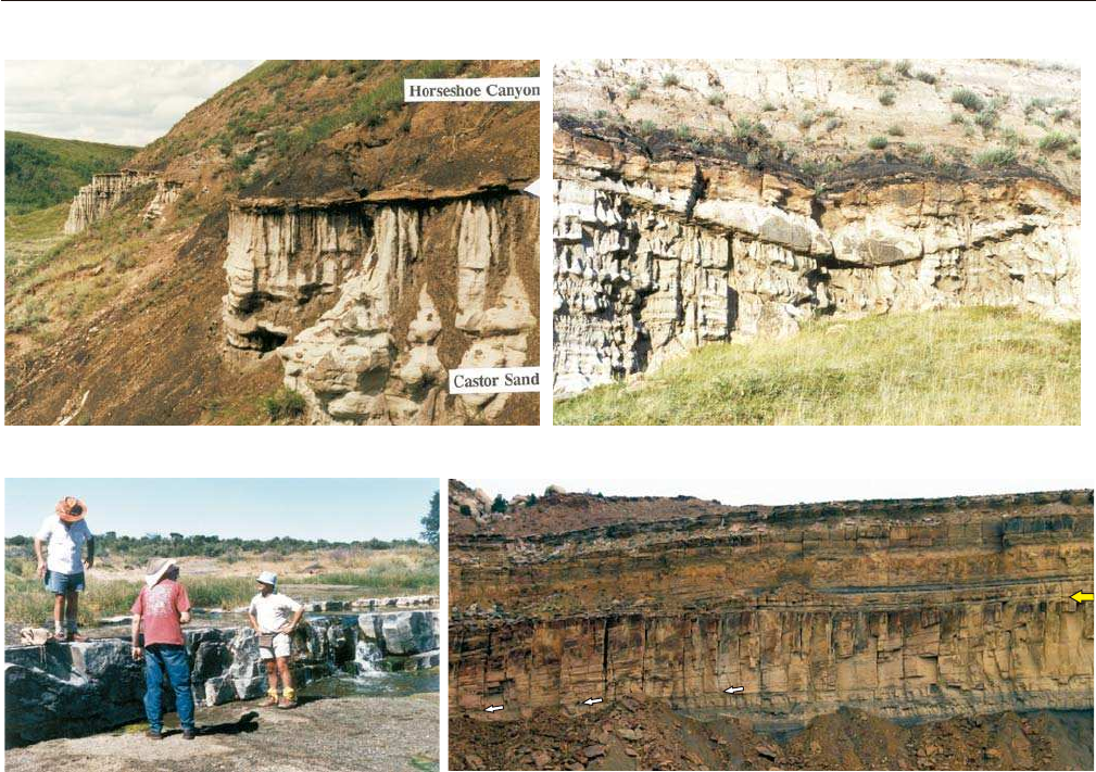
FIGURE 4.56 Outcrop examples of within-trend normal regressive surfaces. A––within-trend normal
regressive surface separating beach sands from the overlying coal-bearing fluvial strata. This facies contact is
conformable, mappable over a relatively large area, but is highly diachronous, with the rate of shoreline
regression. Contact between the uppermost regressive shoreline sands of the Bearpaw Formation and the
overlying Horseshoe Canyon Formation (Early Maastrichtian, Castor area, Western Canada Sedimentary
Basin); B––distributary channel that scours locally the within-trend normal regressive surface in photograph
A; C––within trend normal regressive surface (top of prograding strandplain) exposed by the erosion of the
overlying fluvial floodplain deposits (contact between the Ecca and Beaufort groups, Late Permian, Karoo
Basin); D––within-trend normal regressive surface (larger arrow) at the conformable facies contact between
delta front (deltaic foreset) and the overlying coal-bearing delta plain deposits (deltaic topset). The photo-
graph shows the river-dominated, normal regressive Ferron delta prograding from right to left (Late
Cretaceous, Utah). Abbreviation: NR––normal regressive.
facies details of sequences and systems tracts once the
main sequence stratigraphic framework is outlined by
mapping and correlating the sequence stratigraphic
surfaces.
Within-trend Forced Regressive Surface
The within-trend forced regressive surface is a
conformable facies contact that develops during forced
regressions at the base of prograding delta front facies
of river-dominated deltas (Figs. 4.9 and 4.57). This type
of within-trend facies contact does not develop in
wave-dominated settings, either river-mouth or open
shorelines, because in such settings the regressive
surface of marine erosion forms instead (Fig. 4.23). It is
also noteworthy that the within-trend normal regres-
sive surface does not have an equivalent in a forced
regressive coastal setting, where delta plain and fluvial
WITHIN-TREND FACIES CONTACTS 157
Downlap
Downlap
Delta front (FR)
Prodelta (FR)
Delta front (FR)
Prodelta (FR)
WTFRS
Delta front (FR)
Prodelta (FR)
Transgressive shale
WRS/SU
A
B
C
FIGURE 4.57 Outcrop examples of
within-trend forced regressive surfaces
at the conformable facies contact
between prodelta (deltaic bottomset) and
the overlying coarser-grained delta front
deposits (deltaic foreset) (river-domi-
nated, forced regressive Panther Tongue
delta, Late Cretaceous, Utah). For scale,
note person in image A. The delta front
succession may reach up to 20 m in thick-
ness. The within-trend forced regressive
surface forms only in river-dominated
deltaic settings, and it is highly diachro-
nous, younging basinward with the rate
of forced regression. A––steep delta front
clinoforms (approximately 27°) associ-
ated with grain flow deposits (sand
avalanches in a Gilbert-type delta);
B––finer-grained delta front deposits
(relative to A) associated with lower-
angle clinoforms (approximately 10°)
and the manifestation of turbidity flows;
C––panoramic view showing that the
forced regressive deltaic succession is
truncated at the top by a composite
unconformity that represents a trans-
gressive wave-ravinement surface
reworking a subaerial unconformity.
Abbreviations: FR––forced regressive;
WTFRS––within-trend forced regressive
surface; WRS––transgressive wave-
ravinement surface; SU––subaerial
unconformity.
deposits are missing, being replaced in the rock record by
the subaerial unconformity (Figs. 4.20––wave-dominated
setting, and 4.26––river-dominated setting). As with any
within-trend facies contact, the within-trend forced
regressive surface is characterized by high diachroneity,
becoming younger in a basinward direction with the rate
of shoreline’s forced regression (Fig. 4.9).
The conformable facies contact between prodelta
and overlying delta front facies of forced regressive
river-dominated deltas tends to be sharper than the
corresponding facies contact in normal regressive
settings, because forced regressions are relatively fast,
and hence there is less time for mixing between delta
front and prodelta sediments. As a result, the within-
trend forced regressive surface tends to be prominent
(sharp lithological contact), and therefore relatively easy
to map in outcrop and subsurface (Figs. 4.57 and 4.58).
Although the within-trend forced regressive surface
appears, from a distance, to be a unique facies contact
between prodelta and delta front facies (Fig. 4.57),
detailed analyses from a closer range reveal that the
change from prodelta to the overlying delta front
facies takes place within a relatively narrow zone of
facies transition; as such, no single lithological contact
can be picked unequivocally as the within-trend forced
regressive surface, which, in reality, amalgamates a few
meters thick transitional interval (e.g., about 4–5 m on
the well log in Fig. 4.58). For this reason and in spite of
the relatively sharp lithological contrast that defines
the within-trend forced regressive surface at a larger
scale (Fig. 4.57), the forced regressive delta front
deposits in a river-dominated setting are still ‘grada-
tionally based’, rather than ‘sharp-based’ (Fig. 3.27),
because the succession is conformable (i.e., no regres-
sive surface of marine erosion is present) and the change
from prodelta to delta front facies is gradational even
though the transition takes places rapidly, within a
relatively narrow interval (compare the log in Fig. 4.58,
which shows gradationally based delta front deposits
in a conformable succession, with the logs in Fig. 4.29,
which show a much sharper, and unconformable, facies
contact at the base of the forced regressive shoreface or
delta front deposits that prograde during forced regres-
sion in a wave-dominated setting). Also, in contrast to
the sharp-based delta front or shoreface deposits that
accumulate in wave-dominated settings, the gradation-
ally based delta front succession that overlies the within-
trend forced regressive surface is potentially thicker than
the depth of the fairweather wave base (assuming
preservation from subsequent subaerial and transgres-
sive ravinement erosion), because the toe of the delta
front clinoforms that prograde in a river-dominated
158 4. STRATIGRAPHIC SURFACES
GR
WTFRS
Delta front (FR)
Prodelta (FR)
Transgressive shale
WRS/SU
10 m
FIGURE 4.58 Well-log expression of a within-trend forced regressive surface (modified from images
provided by H.W. Posamentier). The outcrop photograph shows the river-dominated, forced regressive
Panther Tongue delta (image C in Fig. 4.57). Note that the deltaic succession, including the transition from
prodelta to delta front facies, is conformable. The delta front interval (about 20 m in this example) is likely
thicker than the depth of the fairweather wave base, because the toe of the delta front clinoforms that
prograde in a river-dominated setting may reach depths greater than the fairweather wave base. Note that,
from a distance, the within-trend forced regressive surface looks like a unique and well-defined facies contact
(see also additional outcrop examples in Fig. 4.57). From close range, however, no single surface can be picked
unequivocally as a unique lithological contact between prodelta and delta front facies. In reality, the within-
trend forced regressive surface corresponds to a narrow zone of facies transition that may reach a few meters
in thickness. As such, the delta front facies of river-dominated forced-regressive deltas are gradationally
based (see also Fig. 3.27, and compare this well log with the logs provided in Fig. 4.29). Abbreviations:
GR––gamma ray log; FR––forced regressive; WTFRS––within-trend forced regressive surface; WRS––trans-
gressive wave-ravinement surface; SU––subaerial unconformity.

setting may reach depths greater than the fairweather
wave base (Figs. 3.27 and 4.58).
The within-trend forced regressive surface may be
used as a proxy for the basal surface of forced regres-
sion (seafloor at the onset of base-level fall––the
conformable portion of Posamentier and Allen’s, 1999,
sequence boundary), even though the latter is known
to be placed below, within the underlying finer-grained
facies (Posamentier and Allen, 1999). This approxima-
tion is permitted by (1) the high rates of forced regres-
sion, coupled with (2) the low rates of sedimentation
on the continental shelf in front of the prograding delta
front. These two conditions imply that the within-trend
forced regressive surface (above) and the basal surface
of forced regression (below) are relatively close
spatially (with and without a physical expression,
respectively), although, due to the time required by
the shoreline to regress, the two surfaces diverge in a
basinward direction.
Within-trend Flooding Surface
The flooding surface is defined as ‘a surface sepa-
rating younger from older strata across which there is
evidence of an abrupt increase in water depth. This
deepening is commonly accompanied by minor subma-
rine erosion or nondeposition’ (Van Wagoner, 1995).
Even though widely used in sequence stratigraphic
work, the term ‘flooding surface’ is one of the most
controversial concepts in sequence stratigraphy, as it
allows for multiple meanings. The ambiguous nature of
the above definition was discussed by Posamentier and
Allen (1999) who emphasized that it is not clear
whether the flooding surface forms merely as a result
of increasing water depth in a marine (or lacustrine)
environment, or actual flooding of a previously emer-
gent landscape. What is clear is that flooding surfaces,
commonly marked by abrupt facies shifts from sand to
overlying mud in shallow-water settings, form invari-
ably during shoreline transgression, and are topped by
marine (or lacustrine) strata. The nature of the underlying
deposits is however contentious, as they can vary from
fluvial to coastal and shallow-water (Fig. 4.9).
At a semantic level, the usage of the word ‘flooding’
as a generic term that fits all the above scenarios of
facies juxtaposition was challenged by Posamentier
and Allen (1999) who proposed that ‘flooding’ should
be restricted to situations where water overflows onto
land that is normally dry. This definition is consistent
with the common meaning of the word ‘flooding’, and
implies subaerial exposure of the section below, prior
to inundation. Following this rationale, and in order to
avoid semantic confusions, Posamentier and Allen (1999)
suggest replacing the term ‘flooding surface’ as defined
by Van Wagoner (1995) with the more generic term
‘drowning surface’ to indicate a stratigraphic contact
across which an abrupt water deepening is recorded. In
this terminology, flooding surfaces become a special
case of drowning surfaces, where shallow-water facies
overlie nonmarine deposits. A practical problem with
this approach is that evidence for subaerial exposure
prior to the marine (or lacustrine) flooding is required
in order to identify a stratigraphic contact as a ‘flooding
surface’ sensu Posamentier and Allen (1999). Such
evidence, however, may or may not be preserved in the
rock record, depending on the intensity of transgres-
sive ravinement erosion which may remove paleosols,
root traces, or any other proof of subaerial exposure
prior to flooding. On practical grounds, therefore, the
more generic ‘drowning surface’ (or flooding surface
sensu Van Wagoner, 1995) is easier to work with in
terms of designating facies contacts generated by
shoreline transgression, irrespective of the nature of
the underlying deposits. In spite of the terminological
arguments discussed by Posamentier and Allen (1999),
the generic term of ‘flooding surface’ as defined by Van
Wagoner (1995) is still the one that is most commonly
used in current sequence stratigraphic work. Part of the
reason is that the ‘flooding surface’ is heavily entrenched
in the literature, despite the possible misleading
connotation associated with the meaning of the word
‘flooding’. In addition to this, the term ‘drowning’ was
already coined as part of the ‘drowning unconformity’
concept, which is widely used in the context of carbon-
ate sequence stratigraphy (Schlager, 1989).
Flooding surfaces are best observed in coastal to
nearshore shallow-marine settings, where evidence
of water deepening based on facies relationships is
unequivocal (Fig. 4.59). Typical flooding surfaces may
cap regressive successions (i.e., deltaic lobes in river-
mouth settings or beach/shoreface deposits in open
shoreline settings; Figs. 4.35B and 4.59), or transgres-
sive sands (Figs. 4.35E and 4.60). In the former case,
the transgressive deposits are typically absent or very
thin, and the flooding surface may represent the only
evidence of transgression in addition to the occasional
transgressive lags (Kamola and Van Wagoner, 1995).
Flooding surfaces have correlative surfaces in the
coastal plain and shelf environments (Kamola and Van
Wagoner, 1995), and possibly beyond, into the alluvial
plain and deep-water settings, respectively. However,
the identification of such correlative surfaces in
nonmarine or deep-water deposits, unless based on
uniquely correlatable strata such as volcanic ash beds,
serves little purpose and may only be a source of
confusion (Posamentier and Allen, 1999).
The definition provided by Van Wagoner (1995) is
general enough to allow different types of stratigraphic
WITHIN-TREND FACIES CONTACTS 159
