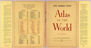
Mid-Century Edition. — Boston: HOUGHTON MIFFLIN COMPANY, 1957. — 60
р.
The first ever Times atlas was published in 1895 and simply called
The Times Atlas, with maps produced by the German firm Velhagen &
Klasing.
In 1826, John Bartholomew set up business as a map engraver in Edinburgh and soon gained an inteational reputation for innovative cartography, high quality copper plate engraving and printing. The Times Publishing Co Ltd thus contracted Bartholomew to prepare a major, new, home produced, world atlas which became The Times Survey Atlas & Gazetteer of the World (1922). This was the beginning of the long running association between Bartholomew and the Times. A series of universally acclaimed atlases followed, including The Times Handy Atlas (1935), The Times Atlas of the World, Mid-Century Edition (1955-59), The Times Comprehensive Atlas of the World (1967), The Times Atlas of the Moon (1969) and The Times Concise Atlas of the World (1972).
Bartholomew continued to prosper by introducing new production techniques and pushing cartographic design to new levels of excellence. The company was bought by Reader’s Digest in 1980, ending the direct involvement of the Bartholomew family. In 1985 it was bought by News Inteational, then in 1989 it became part of HarperCollins Publishers along with Collins Publishers (UK) and Harper & Row (US). Publication of Times atlases and maps continued with the landmark The Times World Political Map and World Physical Map (1989).
The nineties saw a huge change within the cartographic profession with the start of digital technology to produce atlases. The Times Concise Atlas of the World, 7th Edition (1995) was the first fully digital publication produced by Collins Bartholomew. The Times Comprehensive Atlas of the World, 13th Edition (2011) saw even more work in making the mapping digital for the flagship product which is now into its fourteenth edition.
Today, the award winning Collins Bartholomew employs more than 50 cartographers dedicated to upholding the quality, authority and prestige of Times Atlases and Maps.

